Archaeological view of the ruined villages

Visitors who venture along the Meuse remembrance trails are amazed to discover villages that were completely destroyed in the Battle of Verdun and never rebuilt. Besides the commemorative events held here, these places of contemplation are key heritage sites, which archaeologists are today attempting to explore and safeguard for the future.
The region of Lorraine was of especial strategic importance during both world wars. A number of battles were fought here, the most famous and bloody of them being the Battle of Verdun, in 1916. From this period of history, military events are often recounted, while the fate of the civilian population is neglected. The 13 Lorraine villages destroyed in the First World War are a case in point. Totally devastated, six of them would never be rebuilt. Yet they are recognised by the State as having a legal right to exist, in a special historical case unknown to many of the thousands of tourists who visit the battlefield every year. Administratively, this means a mayor is appointed by the prefect to maintain the site and keep the civil records. On the ground, a plaque and commemorative chapel are the only signs of the former dwellings whose ruins are overgrown with vegetation.
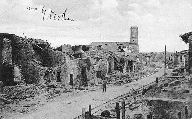
Ornes, captured on 24 February 1916 and liberated in ruins in August 1917, after being totally destroyed by artillery fire on 9 July 1916.
© Archives historiques de la Défense
THE LOST VILLAGES, A HEALED LANDSCAPE
The First World War was a determining factor in the evolution of the Meuse landscape. This violent episode, which can be included in the ‘Anthropocene’, had a profound and irreversible impact on the environment and biogeography of the area of the front. For the first time in the history of human society, a landscape was mutated and fossilised in the space of barely half a century. From ancestral rurality, with its villages, communal fields and woodlands, with the onset of hostilities it was reduced to a mutilated, fissured, devastated land. A few years later, at the end of the conflict, this landscape, deeply damaged by military activity, was reclaimed by spontaneous vegetation, to establish the first battlefield ‘polémo-formes’ (‘war forms’). Around 1920, the mass planting of coniferous trees on the former farmland and ruined villages marked the end of the ‘open field’. Today, in the last stage of evolution, the healed landscape is modelled by forest management authorities and tourism developments. The archaeological remains, usually buried beneath the ground, are in this case buried beneath plant cover, masking their readability.
THE FOREST, PRESERVING THE RUINED VILLAGES
After four years of war, the ravaged landscapes of the Lorraine front were vast abandoned spaces. It was not economically viable for all the land to be recovered. Therefore, by the law of 17 April 1919, the State acquired those lands deemed unrecoverable, and marked them in red on a map. In this way, the Zone Rouge, or ‘Red Zone’, was established. The lands considered most hazardous were entrusted to the forestry authority to be reforested. The Meuse is unique in the history of the ‘Red Zones’, in that it is made up of 79% reforested land. Elsewhere, in the Pas-de-Calais or the Somme, the postwar ‘Red Zones’ were practically all restored to agriculture when the lands were sold.
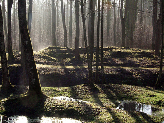
The forest preserving the lost villages, 2016. © D. Jacquemot
Like grassland, forests play a particularly effective role in preventing soil erosion. They enable some structures to be preserved in the soil, while other remnants above ground are fossilised. It has recently been shown that forests planted after the war are also unique heritage reserves. These forests, barely a hundred years old, preserve all the traces of both civilian - farms and ‘martyr’ villages - and military occupation. For instance, the Verdun battlefield consists of 10 000 hectares of ravaged land, including nine villages destroyed by the bombardments.
THE ARCHAEOLOGICAL RESERVE OF THE VILLAGES THAT “DIED FOR FRANCE”
In the 1990s, a discussion about an ‘archaeology of the recent past’ was launched across the spheres of architecture and industrial and military heritage. It showed that, culturally, sites which had been the scene of exceptional or tragic events must preserve their memory, like the ‘lunar soil’ of the Verdun battlefield recently uncovered by LiDAR. On this mythical ground, historic and dramatic episodes can today be characterised. As in the case of Fleury, a village that “died for France”, which was captured and recaptured 16 times by the belligerents in the space of two months. The testimony of this ‘incommunicable’ past is conveyed in the density of the traces that ‘tell’ the story. Unlike museums which sanctify the past through a handful of objects, simply preserving remains in situ allows a space to be ‘read’ and gives meaning to its memory.
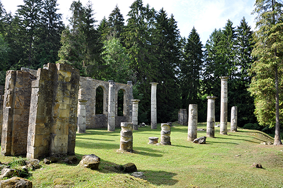
Ornes, remains of the church: symbolic value of what was “sacrificed for Verdun”, 2018. © D. Jacquemot
THE BIO-CULTURAL LEGACY OF THE ‘MARTYR’ VILLAGES
Archaeological prospection has long been interested in the indicative value of vegetation for detecting remains. Anomalies in plant cover betray the nature and composition of anthropised ground. Wooded conflict sites illustrate particularly clearly this close relationship between plant life and human occupation. Such sites are ideal for palaeobotanical studies aimed at piecing together the ecological history of the forests. Despite the mass destruction which had a severe impact on the soil, botanical studies carried out in recent years have identified the presence of ruderal plants (which colonise ruins) and obsidional plants (introduced by military occupation). Such is the case of sisyrinchium bermudiana, a blue-eyed grass native to the archipelago of Bermuda, which is thought to have been spread by the armies in their horse fodder.
A number of historical and scientific studies have been carried out on the wooded areas of the ‘martyr’ villages. In samples taken during the growing season, a series of plants were identified from previous village activities, i.e. before the war. These plants known as ‘relicts’ survived the different stages of transformation of the habitat during the fighting, the abandonment of the site and postwar forestation. Lilac, Oriental leopard’s bane, hop, redcurrant, mock orange, staghorn sumac, daffodil, elder, myrtle, snowdrop and laburnum can all be found here.
Stéphanie Jacquemot, archaeologist, DRAC Grand Est
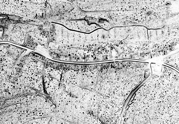
Ornes, a ‘martyr’ village viewed by laser. Verdun National Forest LiDAR Mission, DRAC/ONF Lorraine, March 2013.
© Geomatic processing by R. De Matos-Machado, 2014
The LiDAR system
Famous throughout the world, Verdun is the biggest and most authentic of the First World War battlefields. A century on, this natural space is an open-air history museum and memorial of international importance. This emblematic site, one of the priorities of the Grenelle de l’Environnement forum, has just been labelled an ‘Exceptional Forest’ and over the coming years will have a particular focus on receiving visitors.
Against this background, the Ministry of Culture and the National Forestry Office have just carried out the 3D mapping of the bruised and battered ground of the famous battle, by remote airborne LiDAR (light detection and ranging). This new laser-scanning technology that can penetrate forest cover has just revealed, with centimetric precision, all of the lost villages and remains.
This new archaeological map will aid forestry management and the implementation of a programme of conservation, safeguarding and development. From a scientific point of view, it provides researchers and university students (geographers, historians, archaeologists, etc.) with an exceptional tool for research, reflection and discussion of national heritage.
For educational and tourism development purposes, the 3D images offer a new historical and geographical insight into the Battle of Verdun for visitors to the site.