Newsletter

Navarrenx

Navarrenx. Vue sur l'entrée Saint-Antoine. Source : http://jerome.jauffres74.free.fr

Lying at the heart of the Atlantic Pyrenees southwest of the Béarn plain, Navarrenx has been a fortified town since 1316. It was the first fortified town in what would become the Kingdom of France...

A salmon capital on the streets of Saint-Jacques de Compostelle, Navarrenx was also the first fortified town in what would become the Kingdom of France. Lying at the heart of the Atlantic Pyrenees southwest of the Béarn plain, Navarrenx has been a fortified town since 1316. After the assault by Spanish troops led by Charles Quint who took over the city in 1523, Henri II d'Albret, the king of Navarre, decided to reinforce defences on the right bank of the mountain stream of Oloron. From 1538 to 1546, fortification works were carried out under the direction of Béarn master builders François Girard and Arnaud de Mirassor, as per the design of Italian architectural engineer Fabricio Siciliano.

Less than a century before the birth of Vauban, Navarrenx was thus transformed into a modern fortified town "Italian-style", based on the citadel of Lucas in Tuscany. Later, a powder magazine would be built that would store up to 25000 pounds of gunpowder: a square-shaped construction little more than nine metres long, it was originally surrounded by a wall, part of which was visible aboveground. While this wall has since disappeared, the thickness of this wall (1.4m) and the lowness of the building (6m) prevented it from receiving direct hits from enemy forces.
The fortifications were tried and tested during religious wars under the reign of Jeanne of Albret, when the garrison under the command of the Baron of Arros successfully resisted a three-month siege in 1568. The town was re-equipped in the XVIII century, in particular with the Saint-Antoine gate built by engineer De Salmon on the ruins of an old church. Facing Spain, the gate owed its name to a chapel that welcomed pilgrims and was destroyed during the construction of the ramparts. With three massive arcades, the town was accessed via a drawbridge, the passage of the chains of which can still be seen today. In the XIX century, work on road and rail infrastructure led to the destruction of the old Saint-Germain gate which faced France.
Over the centuries, the fortified wall of Navarrenx has retained its main features. It outlines a reinforced firing range at each of its five corners with a bastion. Two of the five are fitted with anti-mine galleries, while a glacis and ground structures reinforce the town to the east, ahead of the moat. Several barracks have been built inside the walls to house the garrison, one of which nowadays is used as the tourist information office. From the top of the ramparts (for example, from the crenellation platform overhanging the Saint-Antoine gate), there is a pleasant view of the Pyrenees and, below, the arches of the bridge of Navarrenx (XIII century).
Visits There is free access to the 1818-metre perimeter of the town. The walls of the city contain bilingual (French-English) descriptive plaques that trace the history of each structure. Information on guided visits can be obtained from the Navarrenx district tourist office. How to get there 80 km from Bayonne via Peyrehoarde and Escos on the A 64/E 80 (exit no. 6 Peyrehoarde), then the D 936 and D 115. 40 km from Pau via Tarsacq, Noguères and Mourenx along the D 2, the D 281 then the D 111. 60 km from Saint-Jean-Pied-de-Port along the D 933 towards Sauveterre-de-Béarn, then the D 936. 6 km from Gurs along the D 947 and D 936. Canton of Navarrenx Tourist Office L'Arsenal - Rue Saint-Germain 64190 Navarrenx Tel.: 05.59.66.14.93 Fax: 05.59.66.54.80 e-mail : navarrenx@tourisme-bearn-gaves.fr

> Return to results

Practical information

Address

64190
Navarrenx
tél. 05.59.66.14.93Fax. 05.59.66.54.80

Weekly opening hours

Accessible toute l'année

Pegasus Bridge

Pegasus Bridge Photo: ©Yannick LE NEVE

On the "D"Day tourist route, don't miss the Bénouville Bridge, called "Pegasus Bridge" since 1944.


Because the Normandy landing memorial sites are well worth a detour, a tourist route dedicated to D-Day would not be complete without a visit to the site of Bénouville Bridge,called "Pegasus Bridge" since 1944. Installed in 1934, this lift bridge, just over thirty metres long and nearly seven metres wide, was at the cutting-edge of modernity of the time, as it was driven by an electric motor, the task of which was made easier by an impressive concrete counterweight. 


In the night of 5 to 6 June 1944, three Horsa gliders from the British 6th airborne division, under the orders of Major Howard, landed in silence, just a few metres from Bénouville Bridge. Their insignia, a Pegasus, was the name given to the structure thence onwards.
 

The mission of the British 6th Airborne glider infantry was to seize the bridge. Along with the taking of the neighbouring Ranville bridge, the idea was to prevent German reinforcements from hitting the eastern side of the imminent landing.
In addition, cutting the artery between Caen and the sea would preserve a passage for later expansion of the Allied Beach Head. Armed by around fifty men, a 50 mm canon and a little bunker housing a machine gun, the German garrison defending the strategic structure was rapidly dominated by the first liberators on Normandy soil.


"Ham & jam, ham & jam": a few hours after the gliders arrived, this was the radio signal given to announce Major Howard's mission was a success. The commando still had to fight against enemy counter-attacks, notably by elements of the 21st Panzer.

It managed to keep its position and kept the bridge intact until back-up arrived on Sword Beach.

The meeting was finally achieved at around 1pm, with the famous bagpipes of Bill Millin, personal piper of Lord Lovat, playing in the background. Major Howard's parachutists, in control of the only points for crossing the two rivers between Caen and the Channel, made the first D-Day attack, which gave allied troops control of communications between the east and the west of the River Orne and its canal.
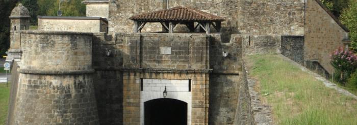


A symbolic site

Immortalised on screen in 1962 during the film The longest day, the first Normandy site under allied control still has many signs of the heroic actions that happened here and which preceded the Landing of 6 June 1944.
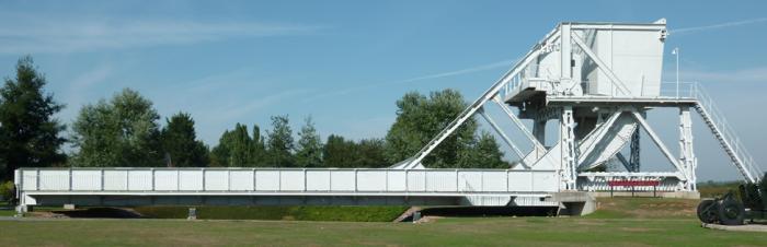
In 1960, Pegasus Bridge was extended by five metres following widening of the canal and was then replaced in 1993 by a new, wider and more modern structure. The new bridge is raised, like its glorious predecessor, and has reproductions of the old railing and wooden pathways from the time. In the centre of the site, visitors can still see the German anti-tank canon in its basin, the role of which was to defend access to the port.
Near the banks of the canal which the bridge spans is a path lined with a bronze bust of Major Howard and three stones mark the exact position of the three gliders. On the opposite bank is the first Normandy house liberated by the allied troops, which is in fact the famous Café Gondrée. In summer, the site puts on a sound and light show which stages the intermingled destinies of Bénouville Bridge and Major Howard's men.


Installed between the River Orne and the canal, the Pegasus Memorial was inaugurated on 4 June 2000 by the Prince of Wales and the French defence minister. In addition to the real Bénouville Bridge, which was reassembled after being taken town in 1993, the memorial has a "Bailey" bridge from 1944: named after a British engineer, these bridges could be assembled by forty sappers in less than three hours and were used to allow heavy military vehicles to pass.
Recently, the ministry of defence (general secretariat for administration; department of memory, heritage and archives) made a financial contribution to the installation of a life-size replica of a Horsa glider in the middle of the park around the memorial.
 

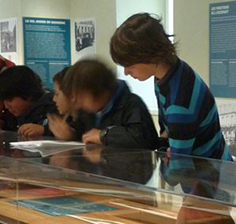
The permanent exhibition areas in the memorial give visitors the opportunity to see films of archives and showcases with an impressive collection of objects and documents to the glory of the British 6th airborne division: fragments of gliders from 1944, soldiers' equipment, Major Howard's personal objects and Bill Millin's bagpipes!
For young visitors and their teachers, the Pegasus memorial offers free of charge an educational file which traces a journey rich in emotions, thus emphasising the necessary orientation of memory actions to the younger generations.


Mémorial de Pegasus Bridge

Avenue du Major Howard 14860 Ranville
Tel. +33 (0)2.31.78.19.44.
Fax: +33 (0)2.31.78.19.42.
Email: memorial.pegasus@wanadoo.fr


Tours
The Pegasus Memorial is open every day, except in December and January. Guided tours (in French or English) are organised upon reservation.


Getting there
Five kilometres from Ouistreham, via the Ranville/Cabourg.exit 


Pegasus Bridge Memorial site


Website of Normandy’s regional tourist committee

> Return to results

Practical information

Address

Place du commandant Kieffer 14860
ranville
02 31 78 19 44 01 43 25 29 67

Prices

Adultes: 6.00 € Enfants et étudiants: 4.50 € Groupes (à partir de 20 personnes) : 4,50 € Gratuit : Chauffeurs et guides accompagnant les groupes

Weekly opening hours

tous les jours de février à novembre, de 10h à 17h

Centre Edmond Michelet

Centre d'études et musée Edmond-Michelet, Brive. Source: Licence Creative Commons. Public domain.

The Centre contributes to historical research and its dissemination for the 20th century period, and more particularly the Second World War.

The Centre was created on the initiative of Marie Michelet, wife of Edmond Michelet, and the Fraternité Edmond Michelet association. The project took shape in the early 1970s.


The Michelet family home was donated to the Association in order to set up the establishment, in partnership with the town of Brive-la-Gaillarde, to study events that occurred in the Second World War, in particular the Resistance and deportation. The Centre Edmond Michelet was inaugurated on 8th May 1976.


From the outset, the project's aim was to be a different memorial. Thus, Marie Michelet always refused that the establishment be a fixed memorial; she wanted it to be a living place, with the permanent exhibition running alongside a space for studies and reflection. This ambition led to the current name of "centre of studies".


Composition:


The establishment consists of a museum, a library and a video library, an archive and documentation section, an events area with permanent exhibitions, mobile exhibitions, conferences and a yearly seminar, and a learning department.


The archive service comprises:


- The Edmond Michelet and Etienne Borne collections

- Collections of former Résistance members, deportees and personalities

- A photo library

- Old newspapers and magazines


The museum has 10 rooms devoted to:


- Edmond Michelet, the Résistance member and the man of State

- The Résistance

- The occupation

- The deportation

- Human Rights

- Propaganda in images


An audio-guide is available for the visit.

The exhibition presents propaganda posters, of which the centre owns a record number in France (around 350) and which give an understanding of the context civilians had to face during the occupation. This museum develops the usual themes of museums dedicated to this period, but takes an object-focused approach.


Centre Edmond Michelet


4 rue Champanatier

19100 Brive la Gaillarde

Tél. : 05 55 74 06 08

museemichelet@brive.fr


Open every day except Sundays and national holidays, from 10 am to 12 pm and 2 pm to 6 pm.

Free entry

Guided tour on request for groups


Site du Centre Edmond Michelet


> Return to results

Practical information

Address

4 rue Champanatier 19100
Brive-la-Gaillarde
05 55 74 06 08

Weekly opening hours

From Monday to Saturday from 10 a.m. to 12 p.m. and 2 p.m to 6 p.m.

Fermetures annuelles

Closed on national holidays

Musée départemental de la résistance Henri Queuille

Former residence of Henri Queuille. Source: ©Fab5669 - License Creative Commons - Public domain.

When Henri Queuille died, in 1976, his heirs donated the house in which he lived all his life to the Corrèze département, to be turned into a museum. The main themes covered are the memory of Henri Queuille and the Résistance.


Background


When Henri Queuille died, in 1970, his heirs donated the house in which he lived all his life to the Corrèze département, to be turned into a museum. The main themes covered are the memory of Henri Queuille and the Résistance.


Thanks to Henri Queuille's collection, donated to the museum by his family, and to Résistance archives and donations from private people, a team made up of former Résistance members, historians and professors successfully brings together and exploits numerous objects and documents. The museum was inaugurated on 4th May 1982 by the President of the Republic, François Mitterrand.


Composition


The museum has 200 m2 of exhibition rooms, divided into five rooms on three levels. They cover the 3rd and 4th Republics, the Résistance and the maquis, Nazi crimes and deportation. It consists of 80 display cases, 100 signs and frames, around 1,500 collection items, including 900 photos and 300 documents and objects.


The museum has an archive of over 1,000 items, a documentary collection of 1,400 items, and the Henri Queuille collection with 35,000 items.
 
The museum has a learning department and a boutique. It also organises "memory trails" in the département.


Musée départemental de la résistance "Henri Queuille"

21 rue du Commerce

19160 Neuvic

Tél. : 33 (0)5 55 46 30 60 - Fax : 33 (0)5 55 46 30 69

Email : musee-henriqueuille@cg19.fr


www.musee-henriqueuille.com


> Return to results

Practical information

Address

Rue du Commerce 19160
Neuvic
05 55 46 30 60

Weekly opening hours

Low season: Monday to Friday 10 am to 12 pm and 2 pm to 6 pm High season: every day from 10 am to 12 pm and 2 pm to 6 pm.

Fermetures annuelles

Closed on 20th December and 1st January.

Musée de la Résistance de Limoges

Cet établissement culturel de la Ville de Limoges illustre les valeurs citoyennes et solidaires portées par la Résistance pendant la Seconde Guerre mondiale. Dédié à tous ceux qui se sont sacrifiés pour défendre les valeurs fondamentales de la République, il a pour vocation d’ouvrir des pages d’histoire en offrant un lieu pédagogique et de diffusion de l’information, notamment pour le jeune public.


Consulter l'offre pédagogique du musée >>>  Limoges


Situé dans l’ancien couvent des Sœurs de la Providence du XVIIe et XVIIIe siècle rue Neuve Saint-Etienne, au cœur au quartier de la Cité, il propose sur 1400 m2 un parcours muséographique retraçant les faits historiques de la Seconde Guerre mondiale et particulièrement la Résistance, l’occupation et la déportation en Haute-Vienne.

Décliné en dix séquences, à partir de 1939, deux plateaux accueillent les collections permanentes, constituées de près de 800 pièces. Le musée comprend également une salle d’expositions temporaires, une salle pédagogique permettant l’organisation d’animations pour les scolaires, et un centre de documentation ouvert aux chercheurs. Ce musée a été réalisé par la Ville de Limoges pour un coût de 7 millions d’euros. Son aménagement a nécessité de très importants travaux entre 2009 et 2011, qui ont permis de valoriser un patrimoine remarquable. En plus du musée de la Résistance l’ensemble immobilier réhabilité comporte une salle de conférence, la salle Simone Veil.


> Return to results

Practical information

Address

7 rue Neuve Saint Etienne 87000
Limoges
05 55 45 84 44

Prices

- Plein tarif : 4 euros- Jeunes (moins de 26 ans) : gratuit- Groupes (à partir de 10 personnes) : 2 euros- Gratuité : moins de 26 ans, étudiants, demandeurs d’emploi ou bénéficiaires de minima sociaux, handicapés, anciens combattants, enseignants, journalistes, membres des Amis du musée de la Résistance, membres de l’ICOM. Gratuit le 1er dimanche du mois.- Pass/tarifs groupés éventuels : formule d’abonnement au musée

Weekly opening hours

Ouvert tous les jours (sauf le mardi) :du 16 septembre au 14 juin inclus, de 9h30 à 17h, ouverture le dimanche après-midi uniquement, de 13h30 à 17h,du 15 juin au 15 septembre inclus : de 10h à 18h.

Fermetures annuelles

Fermeture pour le 25 décembre, le 1er janvier et le 1er mai.Office de tourisme de référence - 12 Boulevard de Fleurus, 87000 Limoges - Tel 05 55 34 46 87

The Fort de l'Infernet

The Fort de l'Infernet. Source : ECPAD

Culminating at 2,380 m, the Fort de l'Infernet is one of a group of forts and batteries constructed around Briançon from 1874 onwards.

Perched on a peak that culminates at 2,380 metres, the Fort de l'Infernet was built to replace the old forts whose defensive purpose progressively dwindled with advances in artillery. It is one of a group of forts and batteries constructed around Briançon from 1874 onwards, as part of the programme known as the "Séré de Rivières system". Like the Fort de la Croix de Bretagne this fort aimed to close off the border with Italy by controlling the valley from a distance.

Built between 1876 and 1878, the fort is characterised by a semi-circular arrangement of canons and an enclosure providing minimal protection. It is at the top of a summit, the artificial levelling of which caused landslides. The garrison of two hundred and ten men and officers was housed in a casemated barracks, protected from dangerous blasts by the mass of its artillery cavalier. The twelve 138 and 155 mm canons were set on the platforms of this cavalier and of the battery in the lower courtyard and directed towards le Pampinet, le Gondran and the Izoard pass.
On the 21st and 23rd June 1940, the two 280 mm Schneider mortar sections (lieutenant Miguet) set up on the slope to the south of the fort neutralised the armour-plated Italian battery that was firing on Briançon from le Chaberton. As the sound of canons resounded for the first time in two centuries, this fortified body thus effectively fulfilled its role as a deterrent.
The Fort de l'Infernet 05100 Briançon Briançon Tourist Information Office Tel. + 33 (0) 4 92 21 08 50 Fax + 33 (0) 4 92 20 56 45 E-mail : office-tourisme-briancon@wanadoo.fr

> Return to results

Practical information

Address

5100
Briançon
04 92 21 08 50

The Fort de la Croix de Bretagne

The Fort de la Croix de Bretagne. Source: ECPAD

The Fort de la Croix de Bretagne was built at the end of the 19th century to protect the borders of the French alpine valleys, under threat from Italy.

The Fort de la Croix de Bretagne is one of three independent forts planned by the Defence Committee when reorganising the defence of Briançon after the invention of rifled artillery. Constructed between 1876 and 1879, it is a perfect example of the necessary adaptation of military architecture to the most difficult rugged terrain. It was complemented by the Grande Maye, a position designed to prevent the breaching of the position of the Gondrans and protect the borders of the French alpine valleys under threat from Italy.

The fort is a long, narrow construction, protected by square towers. It occupies a steep crest that culminates at 2,016 metres, rising up the slope in several tiers connected by an internal twisting road. It provides an unobstructed view over the Fort des Têtes and Mont Prorel. The garrison of four hundred and ninety six men was billeted in a two storey casemated barracks and an officers' lodge. Building B, also casemated and open on two sides, was used as a stable for forty horses, an infirmary that could accommodate 10 patients and a bake-house.
Commissioned on the 25th July 1879, the armaments included seven 155 pieces, five 138's, four mortars distributed across the artillery platforms and twelve canons. The largest one, at the top of the fort, fired across the plateau of the Gondrans. Kept in service until 1940, the fort still belongs to the military sector.

> Return to results

Practical information

Address

5100
Briançon
04 92 21 05 27

The redoubt of les Salettes

Fort des Salettes vu de Briançon. Source : ©MOSSOT - License Creative Commons - Libre de droit

Designed by Vauban after his first visit in 1692, it is situated above the high town on the first of the twisting roads that lead to the Croix de Toulouse.

The town of Briançon, a stronghold on the Durance, did not escape Marshal de Vauban's wisdom. He endowed the town with a citadel and fortified it by installing defence positions on the hills, such as the redoubt of les Salettes which started a tradition of fortification that would see the installation of new defence structures at up to 2,500 m during the 19th and 20th centuries.

Vauban in Briançon: fortifying the town "in a modern way". Fortification project in 1692. The site appeared a difficult one for him to develop, as it was surrounded on all sides by high hills: "You can't imagine anywhere more uneven, with mountains reaching up to the skies and valleys descending into the abyss..." (Vauban in 1692). The town was already protected by a crude wall, built by resident engineer Hue de Langrune between 1689 and 1691. Closely resembling a medieval curtain wall, it had no external fortifications. In his eyes "as the town's new wall was built with a view to protecting it from the affronts of the Barbets and not to withstand a well-planned siege...", there was still everything to do. On the 21st November 1692, he drew up his project for the fortifications to be built in the town and at the château of Briançon. He requested the construction of two demi-lunes, as well as a false bray on the Embrun front. This structure, necessary because of the steep incline, is a kind of step set below the bastioned trace, which provides the potential for more effective grazing fire. He stipulated various developments: the deepening of the moats, the consolidation of the curtain walls, the installation of guard houses, the creation of port holes, traverses and posterns, the vaulting of the gate and the construction of powder stores. To spare the residents from having to provide accommodation for the soldiers, he planned the construction of barracks. Vauban was also concerned about the problem of providing water, as all the sources supplying the town came from outside. He requested the deepening of the well in the Place d'Armes. Vauban considered a significant project for the château, but then abandoned it. On the one hand he feared he would not obtain the necessary funding and on the other, Briançon, although far from the border, was already protected by other strongholds.
Controlling the progress of the work and adapting the projects. Memo of 1700. During his second trip to Briançon, Vauban inspected the work and released a new memo, dated the 24th August 1700, taking into account the loss of the stronghold at Pignerol: "The significance of this place has greatly increased since the destruction of Pignerol" (Vauban in 1700). He envisaged an enlargement of the town under the Embrun gateway, in order to house all the military buildings, as the small size of the town did not allow it to be built within the ramparts (a project that was not followed up). He recommended the erection of a bridge over the Durance, the creation of a road to Montgenèvre, the occupation of the Plateau des Têtes and the construction of a redoubt on the Montagne des Salettes. He drew up 99 articles about the château before finally concluding "that it would be far better to totally demolish this bad old dinosaur... and rebuild everything from scratch". The slow progress of the work led local engineers to take the liberty of making alterations, which enraged Vauban, in particular the project for a counterguard, about which he wrote in 1704: "I see a kind of false bray or covered walkway... which up to now has not been mentioned in the overall project... I note with surprise that Lord Guillyn has taken great delight in adding, removing and altering whatever he likes... if I was younger I would offer to go there from time to time and put it all right ."
Securing the hills Projects for the château Vauban gave this description of the château de Briançon during his first trip in 1692: "The château sits on a high, naturally steep rock above the town, ..., its old enclosure is only two and a half feet thick and is not even terraced... the four towers are quite good (...) in the château (...) there is only one old large square tower with three floors that are used as stores and an arsenal, (...) a guardhouse, a small water tank in poor condition, two or three old outbuildings about to fall into ruin, ten old and six modern barrack rooms, practically no well or latrines and a very poor gate that has neither tread boards nor a drawbridge..." Vauban thus strengthened the existing structure and ordered improvements: a second water tank, latrines and basements.
The redoubt of les Salettes In his first project, Vauban suggested the creation of a machicolated redoubt on the Montagne du Poët. The structure was designed to prevent the enemy from taking this town with its important commanding position over the town and the château. It is highly likely that Vauban took up a suggestion of the engineer Delabat dating from January 1692. In February 1704, he complained that work had not yet begun. It would not start until 1709, two years after Vauban's death, under the supervision of the engineer Tardif and would continue until 1712. The fort looks like a reduced tower, surrounded by a moat and a counterscarp with a reverse fire gallery. Its uniqueness is in the fact that access to the gallery is only possible via a basement leading from the reduit. The tower itself is a square building with graduated sides, on two levels, covered with a pyramid shaped roof. Access is via the first floor across a footbridge over the moat. The barrel-vaulted reverse fire gallery prevented the enemy from breaching the interior moat. Under the reign of Juillet, this redoubt would be converted into a fort by the addition of a bastioned outer defence line (envelope), six Haxo-type casemates and a powder store. The tower would be reinforced with a terraced roof and better equipped with artillery. Continuing Vauban's work: protecting the new border. The end of the reign of Louis XIV was marked by the war of the Spanish Succession from 1701 to 1714, when, once again, France was in conflict with part of Europe. The Briançon area became a place of confrontation between the French and the Savoyards. In 1713, the Treaty of Utrecht brought an end to some of the hostilities. Unfortunately, it turned out to be disastrous for the land of the Escartons. The border, which up until then had been well beyond the mountains, was moved to the watershed in the Montgenèvre pass. France lost Val Cluson, la Varaïta and part of the Val de Suse, receiving in exchange the Ubaye. The town thus became a border zone which required protection. The construction of a veritable barrier of forts began under the Regency in July 1721 and continued for thirteen summers under the reign of Louis XV. Claude François Bidal, Marquis Marshal of Asfeld, a follower and the successor of Vauban, would be in charge of the work as Director General of the fortifications of France. As reinforcements for the fortifications of the town and of the redoubt of les Salettes, seven "Vauban style" fortifications would be built around the town: the Trois-Têtes, Randouillet, Dauphin, and Anjou forts, the Point du Jour redoubt, Communication Y and the Asfeld Bridge.
The redoubt of les Salettes Route de l'Italie 05100 Briançon Tel.: + 33 (0) 4 92 21 08 50 Fax : + 33 (0) 4 92 20 56 45 Guided tours are provided by lecturers from the heritage department Town of Briançon - Heritage Department Porte de Pignerol 05100 Briançon Tel: + 33 (0) 4 92 20 29 49 Fax: + 33 (0) 4 92 20 39 84 E-mail: patrimoine@mairie-briancon.fr The Club du Vieux Manoir restores and hosts activities during the summer season in the Forts of les Salettes and the Château, which belong to the town. The ancient Abbey du Moncel 60700 Pontpoint Tel: + 33 (0) 3 44 72 33 98

> Return to results

Practical information

Address

5100
Briançon
04 92 21 08 50

Prices

Plein tarif: 6-7 € Tarif réduit: 4,50-5,50 € Gratuit : Enfant de moins de 12 ans

Weekly opening hours

Du 18 au 30 juin et du 1er au 18 septembre: le mercredi, jeudi et vendredi de 11h à 18h. Du 1°Juillet au 31 Août: tout les jours sauf le dimanche, de 11h à 18h

Fermetures annuelles

Fermé du 18 septembre au 18 juin

The Mont-Dauphin citadel

Mont-Dauphin, place fortifiée par Vauban. Source : GNU Free Documentation License

Entirely built by Vauban from1693 onwards, the citadel was intended to prevent access from the Valley of the Durance by the troops of the Duke of the Savoie.

Entirely built by Vauban from1693 onwards, the Mont-Dauphin citadel was thus named in honour of the son of Louis XIV. It was intended to prevent access from the Valley of the Durance by the troops of the Duke of the Savoie.

Opposite the Fort des Salettes, at the foot of the Col de l'Infernet, it is a fortification on several levels with two fortified sides, positioned on a rocky promontory (1400 m) offering imposing natural defences. Its peculiarity comes from an imposing wall (2.20 m wide by 9.30 m high), which crosses the fort lengthwise, backed onto by the only barracks building. This advance post, built on the edge of a forest, watched over the Vallon du Fontenil and protected the Fort des Têtes. With its outlook it allowed the Fort des Salettes to completely secure the route from Italy.
The Mont-Dauphin citadel 05100 Briançon Mont-Dauphin Tourist Information Office Tel.: +33 (0) 4.92.45.17.80

> Return to results

Practical information

Address

5100
Briançon
04 92 45 42 40

Prices

Plein tarif: 7,50 € Tarif réduit: 4,50 € Groupe (+ de 20 personnes) : 6 € Groupes scolaires(35 élèves maximum): 30 €

Weekly opening hours

Visite guidée En juin et septembre: 10h et 15h En juillet et août:10h, 15h et 16h De octobre à mai: 15h (sauf le lundi)

Fermetures annuelles

Fermé le 1er janvier, 1er mai, 1er et 11 novembre, 25 décembre.

Fort du Randouillet

Fort du Randouillet. Source : ©Thomas Grollier - License Creative Commons - Libre de droit

From its high position at an altitude of 1604 metres Fort du Randouillet's purpose was to protect the Fort des Têtes, whilst controlling access to the Cervières valley.

From its high position at an altitude of 1604 metres, Fort du Randouillet's purpose was to protect the Fort des Têtes from potential attackers, whilst controlling access to the Cervières valley.

The upper part of the fort consists of a dungeon, inside which are the major elements of defence. The fort's lower level housed the barracks buildings. From 1724 onwards, work began to strengthen this collection of fortifications under the supervision of the Marquis of Asfeld. A two hundred metre long covered gallery, the "y communication route " blocked the small Fontchristiane valley to link the Fort du Randouillet and the Fort des Têtes. The town was connected to these two forts by the Asfeld bridge, which spanned the two banks of the Durance at the bottom of a fifty metre deep gorge. The linking of these forts now formed a veritable barrier of fortifications.
However, advances in artillery and tensions with the neighbouring Italians led to the construction of new forts from 1882 onwards, in order to provide security for the most important passes.
Fort du Randouillet 05100 Briançon Briançon Tourist Information Office Tours are often organised for you to visit the fortified town, the high-altitude forts and the monuments in the Briançon area. Tel. + 33 (0) 4 92 21 08 50 Fax + 33 (0) 4 92 20 56 45 E-mail: office-tourisme-briancon@wanadoo.fr

> Return to results

Practical information

Address

5100
Briançon
04 92 21 08 50