The fortifications in Esseillon
Fort d’Esseillon vu depuis la via ferrata du Diable à Aussois. © Savoie Mont Blanc / Desage
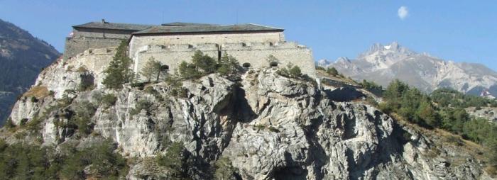
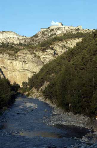
Dominating the Arc Valley along two kilometres over Modane, the rocky foothills of Esseillon, a natural defensive barrier a hundred metres high, blocks the access to the Haute-Maurienne Valley and Mont-Cenis Pass.
In 1815, the Congress of Vienna sentenced France to return Savoy to the King of Piedmont-Sardinia, allied with Austria. Victor-Emmanuel I used a proportion of the ample compensation paid by France to fortify the Alpine barrier and block the French army's passage into Italy.
Since the glacial rock bar allowing access into Piedmont was no longer protected since Napoleon had destroyed the fortress of Brunetta de Susa in 1796, the decision was made to reinforce the protection of the routes between France and Italy around Esseillon.
Dominating the Arc Valley along two kilometres over Modane, the rocky foothills of Esseillon, a natural defensive barrier a hundred metres high, blocks the access to the Haute-Maurienne Valley and Mont-Cenis Pass, between Savoy and Turin. In 1817, excavation was started to strip the rock intended to hold the future constructions. At the heart of the grandiose mountains of Haute-Maurienne, the huge construction of a military town was entrusted to a young captain from Piedmont, Olivero.
Educated on Austrian defence systems, he put into practice the theories of Marquis de Montalembert, a French artillery general in the 18th century: the forts were designed to block the enemy’s path following a line of defence perpendicular to the direction of their progression. Five structures were erected, the way the valley flared placing everything out of the reach of enemy artillery stationed on the surrounding summits. Named after the first names of members of the royal family of the House of Savoy, these thick-walled forts flanked by breaks making crossfire possible. They form a majestic architectural ensemble that effectively fulfilled its role of blocking the path through Mont-Cenis Pass, the gateway into Italy, until 1860.
In this year, marked by Savoy's reannexation to France, the crenellations cut into the fort walls, mainly directed towards France, now served no purpose. The defence structures in Esseillon were modified by the French, in such a way as to counter invaders coming from the East.
In 1871, drilling started on the Fréjus Rail Tunnel, transferring the border defence fortifications to the valley around Modane. Stripped of any strategic interest and weakened by shells, these remote and cold imposing structures perched at over one thousand five hundred metres altitude were downgraded to a site for holding disciplinary battalions or prisoners. The fortifications were saved from fire until the Second World War.
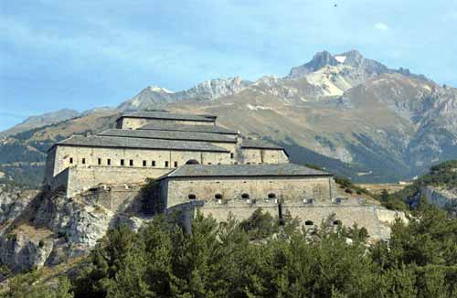
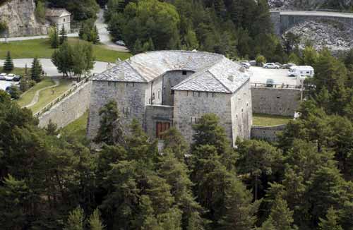
Built between 1818 and 1828, Fort Victor-Emmanuel was the major component of the Esseillon defence system. Sat at the edge of a cliff at 1,350 metres altitude, the fort comprises a parallel series of eight, two-storey buildings, two of which were specifically batteries for cannons. The main entrance, reached by a wooden bridge extended by a metal drawbridge, led through to the headquarters building that housed the staff, the barracks, and logistics buildings, including two wells that supplied the garrison with water.
The fort’s fire plans were directed towards the village of Avrieux and the royal road connecting Chambéry to Turin, although a number of embrasures also flanked the area surrounding the Marie-Thérèse redoubt. A path suitable for motor vehicles bordered by projecting stones snaked inside the fort and facilitated the movement of batteries. Inside the building, a maze of staircases and vaulted galleries provided easy access for moving cannons about. On the Sardinian side, a ditch was bordered with caponiers, structures detached from the escarp.
A prison was built in 1833 for the purpose of holding Italian liberals. Initially conceived as a base station in the event of an attack, the fort was designed to hold a garrison of 1,500 men serving 35 cannons. A thriving hub, it also contained a hospital and a chapel. In June 1940, it was at the centre of the defence system of the 281st artillery regiment, before being used by the Italians, who started to imprison French resistance fighters there in 1943. During the course of winter 1944, Fort Victor-Emmanuel was used as a support base for the 6th battalion of Alpine hunter operating against the German troops entrenched at Mont-Cenis. Today, some entrance points into the fort are dangerous and are currently being reinforced as part of the general restoration programme of the complex.
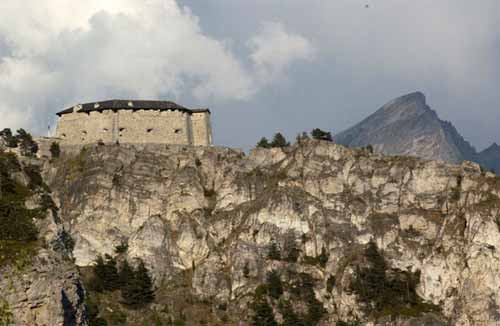
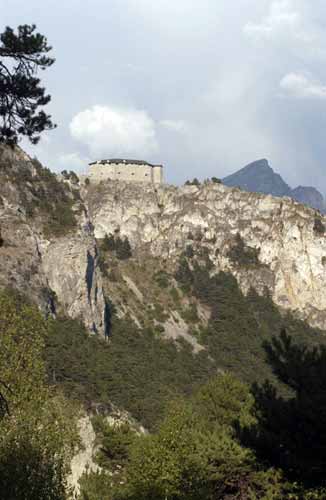
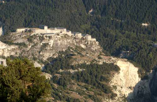
Erected between 1819 and 1830, Fort Marie-Christine is the highest fort of the complex overlooking the structure in its entirety from an altitude of 1,500 metres. A typical perpendicular fortification structure popular with Marquis de Montalembert, rid of its traditional bastions, the hexagonal complex still maintains a perpendicular face to the enemy. Dedicated to defending the north side of the valley, the fort and its 20 cannons provided an effective flank of the Charles-Albert and Charles-Félix forts as well as the road leading to Aussois.
Encircled by a wall and preceded by a ditch in the east, and a vertiginous cliff to the west, the fort was built over three levels: a ground floor occupied by rooms used for logistics; a first floor where the army barracks were situated, and an upper level consisting of a covered terrace with cannon embrasures. The main entrance was protected by a weighbridge positioned under the crenellations at the guard posts. The central courtyard is surrounded by blockhouses surmounted with vaults that could hold up to 500 men. Originally, a secure passage was provided to Fort Charles-Albert by a long low building that is no longer standing today.
Entirely renovated, today Fort Marie-Christine offers visitors a number of features in addition to its historical interest and importance as a national monument. Housing a gîte and a restaurant, it is a fascinating place to stay and enjoy a meal. Also an activity centre, in 1987 it was made the fifth entrance to Vanoise National Park and offers climbing enthusiasts a range of well-established ascents for both novices and the more experienced.
Protected in the north by the Arc Abyss, to the west of the Saint-Anne Nant ravine, Marie-Thérèse redoubt is the only structure in the Esseillon defence system built on the left bank of the Arc Valley. Constructed from 1819 to 1825, this redoubt in the town of Avrieux was intended to block the Route Royale through Mont-Cenis Pass.
Within reach of the cannons at Fort Victor-Emmanuel, from the other side of the abyss, the structure resembles an irregularly-shaped horse shoe, the western end extended to house the entranceway and the weighbridge facing France. Designed to hold a garrison of two hundred men, the Marie-Thérèse redoubt was organised over two levels of vaulted blockhouses placed around a modest central courtyard. On the upper level, visitors can see triple embrasures, which can accept one cannon and two rifles. A shooting gallery buried in the counterscarp of the ditch thus guaranteed an efficient close defence system. Goods were initially supplied using a system of cables erected across the Arc Ravine and connecting the structure to Fort Victor-Emmanuel. Then in 1850, a narrow suspension bridge over the abyss broke the redoubt’s isolated position by connecting it to the structures located on the opposite side of the Arc Gorges: a covered walkway stretched the length of the bridge, which was defended by a guardroom.
The same year, a swing bridge controlled by a small fort set 50 metres back from the redoubt was erected to protect the access to the fort.
In June 1940, the redoubt was occupied by the 281st infantry regiment, then, after the armistice, by the Italian and German troops until September 1944. Currently under renovation, a part of the structure is today open to visitors. Suspended 100 metres over the void, the bravest visitors can enjoy an unspoilt view over the Arc Gorges from the ‘devil’s bridge’. This gangway destroyed in 1940 was reconstructed in 1989 as part of the project to open the Esseillon site as a cultural and sports site and is today one of the starting points of the via ferrata climbing trail.
Completed in 1827, this building, just like Fort Marie-Christine (wife of Charles-Félix) formed a small unit designed to block the path of troops along the road connecting Aussois and Modane. Stood on the western cliff, it was accessed from the east via an earth ramp leading to an immense door made from hewn stones facing Fort Victor-Emmanuel.
To the rear of the building, a cemetery, known as the Sardinian Cemetery, was used to bury the dead from across the Esseillon site.
When Savoy was annexed to France in 1860, the agreements signed by Napoleon III and Cavour, the prime minister of the nascent state of Italy, stipulated that the fortified complex at Esseilon must be completely destroyed. However, Fort Charles-Félix was the only structure wrecked on the emperor’s order, after three days of shellfire. Visitors are strongly dissuaded from entering the structure today due to the high risks of collapsing walls. Between Fort Marie-Christine and Fort Victor-Emmanuel, the fort ruins make a breathtaking site from the main road, revealing the former dungeon surrounded by a star-shaped wall.
In 1832, the construction of a last fort was started. This was due to the fact that the defence system made up of the existing four structures contained a breach north of the village of Aussois. Linked by a trench to Fort Marie-Christine standing at the same altitude, Fort Charles-Albert was therefore intended to complete the entire complex by blocking access to the north of the site of Esseillon. The structure was never completed and the construction terminated in 1834. Today, only the ruins of two small garrison buildings and the base of one tower can be seen overlooking the valley in Aussois.
Esseillon Fort
Aussois Tourist Information Centre, Maison d’Aussois, 73500, Aussoi
Tel: +33 (0)4 79 20 30 80
Fax: 04.79.20.40.23
Email: info@aussois.com
Tours
Visitors can take guided tours around the buildings open to the public. The new vocation of Esseillon’s defence system is also enhanced by numerous tourist trails with a variety of themes. Nature trails are a great way to explore the wealth of flora and fauna in the region, offering routes to be explored by foot or snowshoe via a network of footpaths, climbing trails for the more athletic or restoration projects at the structures in high season for a more laborious activity. There are a variety of ways to discover the forts in Esseillon and the area surrounding this unique fortified complex in France.
Getting there
From Chambéry (107 km), Grenoble (145 km), Lyon (220 km), Geneva (200 km), or Turin (110 km), via the alpine A43 or A41 motorways (exit at Modane). From Modane (7 km), international train station, by the D215.
Site of Maison d’Aussois
Le fort Victor-Emmanuel. Source : Photo ECPAD
Le fort Marie-Christine. Source : Photo ECPAD
Le fort Marie-Christine. Source : Photo ECPAD
Le fort Marie-Christine. Source : Photo ECPAD
La redoute Marie-Thérèse. Source : Photo ECPAD
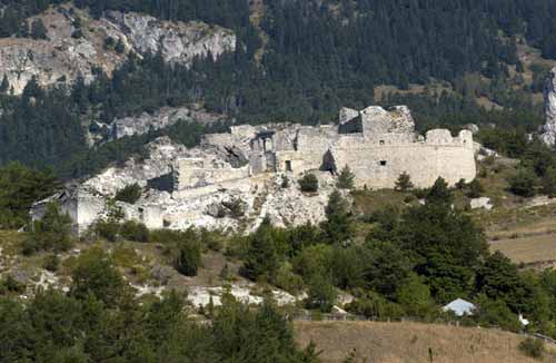
Le fort Charles-Félix. Source : Photo ECPAD
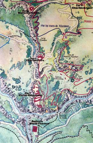
Plan du site fortifié de l'Esseillon. Source : Photo ECPAD
Le fort Victor-Emmanuel. Source : Photo ECPAD
Practical information
73500
L'Esseillon
tél. 04.79.20.30.80Fax. 04.79.20.40.23
Accessible toute l'année