The Landing Beaches, Normandy 1944

Every year, millions of visitors come to the landing beaches to contemplate the traces left by the largest amphibious and airborne operation of all time. Transformed by the landings of June 1944, this coastal landscape today appears at peace. However, its conservation and recognition remain a key issue.
The landscape of the Normandy coastline that served as the backdrop to Operation Neptune, the first phase of Operation Overlord, launched on 6 June 1944, is in fact a series of coastal landscapes: the plain and marshes of Cotentin, the cliffs of Bessin and the coastline of Nacre. It is characterised by alternating foreshores bordered with more or less marked dune belts, cliffs, coastal marshes and estuaries. The submerged areas near this shoreline of the Seine Bay present varying morphologies and bathymetric profiles, with a significant presence of wave-cut platforms.
THE ATLANTIC WALL
Before the war, this coastline was still predominantly rural, particularly the western part: in Cotentin, the shore was accessible only via a handful of “causeways” across the marshes, used for cattle grazing in summer and flooded in winter; Bessin was not very built up, with an economy based on arable and livestock farming and inshore fishing. Meanwhile, the late-19th-century fashion for sea bathing led to the development of beach tourism and, in the western section, family seaside resorts sprang up. On what was to become Omaha Beach the first villas and family hotels were built, Arromanches became a much sought-after holiday destination, and the coastline from Courseulles-sur-Mer to Ouistreham (Juno and Sword sectors), due to its proximity to Caen, saw a major period of development, with the construction of promenades, casinos, hotels, and beach huts still typical of this part of the French coast today.
Here, as all along the Channel and Atlantic coasts, the landscape is marked by German occupation from 1940 onwards, and in particular from 1942, when the war became a world war and Germany embarked on the construction of a line of defences known as the Atlantic Wall. This project of vast proportions was not fully completed until 1944. Contrary to what the word “wall” might lead one to expect, it was not a continuous barrier, comprising instead four types of defences: forts, coastal artillery batteries, fortifications close to the beaches and obstacles on the beaches.
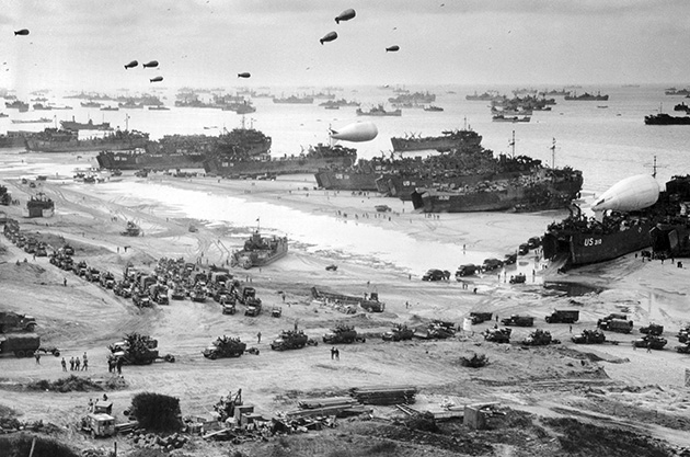
Soldiers and military vehicles land on Omaha Beach during Operation Overlord, 10 June 1944.
© TopFoto / Roger-Viollet
Since the Anglo-Canadian raid on Dieppe in August 1942, the Germans were convinced that the Allies would try to seize a port on their next attempted landing on the European continent. All the ports regarded as important on the western coast of Europe were therefore turned into fortresses. Thus, the ports of Cherbourg and Le Havre, on either side of the Seine Bay, were solidly fortified. Between the fortresses, the Germans installed coastal artillery batteries, each with three to six guns. There were over 20 between Cherbourg and Le Havre, with two in particular right at the heart of the future zone of attack: at Pointe du Hoc, between Utah and Omaha beaches, and Longues-sur-Mer, between Omaha and Gold. The fortifications near the beaches were strongpoints at close proximity to the shore, designed to defend the beaches against the assault troops. They generally consisted of one or two pillboxes equipped with medium-calibre guns. By the spring of 1944, no less than 200 strongpoints had been set up along the coast of the Seine Bay. Finally, from 1943 onwards, the beaches were equipped with additional obstacles, such as anti-tank walls, wooden stakes known as “Rommel’s asparagus”, and mines. The coastal marshes were flooded in order to protect the hinterland and counter a potential airborne attack.
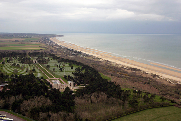
Aerial view of the landing beaches and the Normandy American Cemetery at Colleville-sur-Mer, 31 March 2004. © D. Viola / DICOD
TOWARDS OPERATION NEPTUNE
The gathering of materials needed to build the Wall, such as pebbles from the beach of Colleville-sur-Mer, changed the face of the coastline. The landscape was also impacted by the demolition of seaside villas on German orders, to leave unobstructed coastal viewpoints. In the east, the Germans took advantage of the sea walls and buildings along the seafront to install observation posts in the existing structures.
The Allies’ choice of this section of the Normandy coast for Operation Neptune, limited to east and west by vast areas of wetland unfit for landing – the Carentan and Dives marshes – meant that meticulous planning was required. That planning was guided by accurate knowledge of the bathymetry and geomorphology of the coast (position of sand bars, presence of rocks). The area was divided into five sectors – codenamed Utah, Omaha, Gold, Juno and Sword – not only for military reasons, but also because of geographical constraints. The cliffed coastline was placed outside the landing zone, with the exception of Pointe du Hoc, which was maintained as a target due to the presence of a key German battery likely to pose a threat to operations in the Utah and Omaha sectors. The areas chosen for this amphibious operation were the sections of coastline with sandy beaches, which nevertheless had one major drawback: the wave-cut platforms that extend off the coast of Calvados make for dangerous navigation. Using the Allied fleet to keep the front line supplied with troops and equipment had proved a technical challenge requiring the construction of two artificial harbours, prefabricated in southern England: Mulberry A in the American sector, and Mulberry B in the British sector. Their construction had been decided after night-time reconnaissance showed the sea bed to be deeper and more stable in these locations.
The launch of Operation Neptune on 6 June 1944 and the Battle of Normandy that followed would leave a lasting mark on the landscape of the landing beaches. The battle went on for longer than expected. Normandy was liberated in late August, after the closing of the Falaise Pocket. But the landing operations on the Normandy beaches went on into November, until victory in the Battle of the Scheldt had opened up the port of Antwerp to get supplies to the front.
CLEARING THE BEACHES
In liberated Normandy, life returned to normal in a landscape deeply scarred by the military occupation and fighting. Coastal sites were particularly badly affected by the Allied aerial bombardment. Fire had also destroyed the plant cover. The landing sites and surrounding area were piled high with abandoned equipment, mines and unexploded shells. The Seine Bay was littered with wrecks, which hampered the resumption of any activity. Mine clearance and cleaning operations were undertaken with some urgency. Intensive demining went on until 1947.
The Caen Interdepartmental Demining Centre continues to play an important role today, carrying out on average over a thousand mine-clearance operations every year across the departments of Calvados and Manche. Mine-clearance operations at sea and on the foreshore are carried out by the French Navy’s Mine Clearance Divers Group, based in Cherbourg, which performs around 40 operations per year in the area.
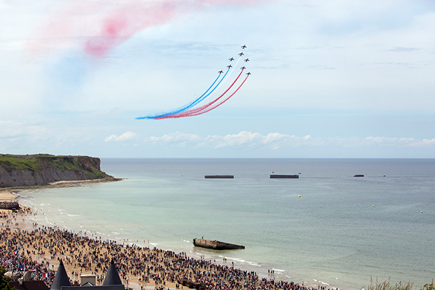
70th anniversary of the Normandy landings, 6 June 2014. © R. Senoussi / DICOD
The task of clearing the beaches and sea bed got underway in November 1944. It would go on for many years around the Seine Bay. Abandoned equipment, such as wrecks grounded near the coast, were scrapped. In 1949, vast sites were set up along the coast by firms specialising in refloating wrecked ships and recovering scrap metal. One final concession was awarded in the 1970s to salvage the last remaining wrecks, which remained a hazard to shipping. The five “gooseberries”, comprised of dozens of ships deliberately sunk by the Allies to act as a breakwater, suffered the same fate. The metal parts of the artificial harbour (floating piers) were likewise dismantled in 1945. The coastal communes took additional steps to secure some sites, levelling some defences or deliberately allowing bunkers to become overgrown with vegetation. Thus, the war landscape of the landing beaches was gradually transformed, to become a far cry from the conflict landscape left behind by the troops after the battle.
THE CHALLENGE OF PRESERVING THE SITES
However, some remnants were deliberately preserved. Immediately after the war, local stakeholders asserted their desire to conserve the traces of an event that had left a lasting mark on Normandy and its population. Among them was Raymond Triboulet, appointed deputy prefect of Bayeux in June 1944. Triboulet founded the Landings Committee on 22 May 1945.
Elected to the French parliament, on 21 May 1947 he tabled a bill to make commemorations of the Normandy landings a national concern. Under the new law, the State was responsible for the preservation and development of historic sites and the construction of museums. Two sites are particularly noteworthy in terms of conservation: Pointe du Hoc (in 1945, Grandcamp-les-Bains tourist office obtained permission for the site to be preserved in its current state, and in 1955 it was made a listed site); and Longues-sur-Mer battery, which is a protected landscape, with five of its ruins listed historic monuments. Everywhere, the coastal dynamic – receding cliffs, the phenomena of dune growth or decay – is slowly changing the visual impact of these remains in the landscape. In the western section of the landing beaches, the resumption of beach tourism contributed to the disappearance of traces of the event from the landscape. Some openly admitted their goal of wiping away the scars. However, the emergence of “remembrance tourism” counterbalanced this trend. Much work has been done over the decades, since the founding of the first D-Day Museum, in Arromanches-les-Bains, in 1954, on the initiative of the Landings Committee. The former belligerents have made a major contribution to the preservation and development of this remembrance site.
Today, this battle-scarred landscape is unquestionably at peace. The proposed nomination of the Normandy landing beaches for inclusion on the UNESCO World Heritage List is a partnership initiative, which became a reality with the submission of a nomination file in January 2018. It represents the furthering of a shared desire to preserve these sites because of the significance of the events of 6 June 1944: a fight for freedom and a victory no nation could enjoy alone, leading to a lasting peace. Over the years, the landing beaches have thus become a site of shared remembrance, a place for the citizens of the world to gather round a universal message of freedom and peace. In this light, the Normandy landing beaches have been nominated for inclusion on the UNESCO World Heritage List of cultural landscapes, as a historic landscape which at once bears the traces of a conflict, while also presenting a community dimension.