Newsletter

La Coupole

©La Coupole

Située à 5 km de Saint-Omer, La Coupole figure parmi les vestiges les plus impressionnants de la Seconde Guerre mondiale. En quelques chiffres, c’est un dôme colossal de 71 mètres de diamètre, 55.000 tonnes de béton armé et 5,5 mètres d’épaisseur !


Consulter l'offre pédagogique du centre >>>  Saint-Omer


Lire un article sur La Coupole


Par sa masse écrasante, par le caractère souterrain de ses installations, par la souffrance des travailleurs forcés qui l’ont édifié, le site constitue un lieu symbolique de la folie nazie.

Il s’agit de l’une des « constructions spéciales » édifiées par l’armée allemande, en 1943-1944, pour permettre la mise en opération de nouveaux systèmes d’armes V destinés à frapper l’Angleterre.

Cet immense bunker, construit par l’organisation Todt en 1943-1944, était destiné à stocker, préparer et lancer vers le centre-ville de Londres l’arme secrète de Hitler : la fusée V2.

Ce furent les bombardements, puis la percée des troupes anglo-américaines en Normandie, à la fin juillet 1944, qui incita les Allemands à abandonner le chantier de La Coupole, à quelques semaines de son achèvement. Ainsi, aucune fusée V2 n’a pu décoller d’un site conçu comme la première base de missiles stratégiques de l’Histoire.

Réhabilité en 1997, le Centre d’Histoire présente deux circuits de visite : « Les Armes secrètes d’Hitler : V1 et V2 » et « Le Nord de la France dans la main allemande » sur les grandes périodes de l’Occupation : l’invasion, l’exode, la vie quotidienne, la Résistance, la collaboration et la Libération.

Vous découvrez également que derrière cette arme, il y a le parcours d’un jeune ingénieur allemand, Wernher von Braun, inventeur de la fusée V2, récupéré par les Américains au lendemain de la guerre et qui mettra au point, l’immense fusée Saturn V qui enverra l’Homme sur la Lune….

La conquête spatiale débute donc bien ici sur les traces des premiers pas de l’Homme sur la Lune et elle se poursuit au Planétarium où vous serez plongés dans l’univers en totale immersion grâce à une technologie 10K-3D unique au monde !

Munis de lunettes actives dernière génération vous serez plongés parmi les étoiles grâce à l’écran à 360° de 15 mètres de diamètre.


> Return to results

Practical information

Address

Rue André Clabaux 62570
Wizernes
03 21 12 27 27

Prices

Voir site internet

Weekly opening hours

De 9h à 17h30 se septembre à mars / De 9h à 18h d’avril à juin / De 9h à 19h en juillet et en août

Fermetures annuelles

Fermeture les 25/12 et 1/01 et les deux premières semaines de janvier

Saline royale d'Arc et Senans

Vue panoramique. Source : http://www.salineroyale.com/

The Royal Saltworks of Arc-et-Senans, the architectural masterpiece of Claude-Nicolas Ledoux, was used as an internment camp for Gypsies...

Internment of the Gypsies

In May 1941, the Feldkommandantur for Besançon decided to apply the decree passed on 4th October 1940 forcing travelling people in the occupied zone to be held together in internment camps. This measure was initially aimed at those in the Belfort, Doubs, Haute-Saône and Jura areas. It was then extended to cover those in the Côte-d'Or, Haute-Marne, Saône-et-Loire and Ain Departements. Thus, on 24th June 1941, the first travellers from Belfort were sent to the Châtelain and Châtelaine forest houses belonging to the Chaux estate, 22 km from Dôle. But this location quickly proved unsuitable. Insufficient accommodation and water that was unfit to drink caused the German authorities to transfer the Gypsies to the Arc-et-Senans Saltworks on 1st September 1941.
Built by architect Claude Nicolas LEDOUX, and owned by the Doubs Departement since 1927, the Royal Saltworks at that time was in a very poor state of repair despite initial restoration work carried out between 1930 and 1936. Among other things it had already been used as an assembly centre for Spanish Republicans between February and October 1939, before being requisitioned by the French Army during the Phoney War. The Germans then took possession of the place during the first half of 1941, until their departure. Until 15th May 1942, the status of the Arc-et-Senans camp, run by four Customs Officers, was that of an assembly centre. In effect, this meant that the Gypsies, grouped into whole families, could leave the camp area, through the use of exit passes. This period was also notable for the absence of common buildings which meant that the travelling people had to live by their own means. Thus, in order to support their families, some adults went to work in neighbouring businesses such as engineering firm UMAS (Union métallurgique d'Arc-et-Senans) or the Todt organisation. In addition, the sanitation was appalling; the showers were unusable, the toilets did not work and there were inadequate fresh water supplies... The lack of hygiene gave rise to diseases such as scabies, and many gypsies had to be transferred to the hospitals in Besançon for treatment. Meanwhile, an excessive number of escapes and exit passes that were too freely issued led to many complaints from the inhabitants of Arc-et-Senans. And on 15th May 1942, the order was given for the Royal Saltworks to become an internment camp. The changes were radical; people were no longer permitted to leave and as a result some hitherto absent facilities were rapidly installed. These included soup-kitchen style catering facilities, as well as an infirmary and a school able to take the 58 children registered at the camp. Despite these transformations, the Gypsy population still lived in difficult conditions. A report issued by the Camp Governor in August 1943, revealed that of the 185 internees, 44 suffered from skin complaints: infected wounds, abscesses, varicose ulcers, etc. Furthermore, the escapes continued. This undoubtedly led to the closure of the camp at Arc-et-Senans on 11th September 1943 and the transfer of the Gypsy families to the Jargeau internment camp in the Loiret region. This dramatic episode in the history of the Royal Saltworks has not been forgotten. On 11th and 12th March 1999 - as part of a major event entitled "A Look at Travelling People", organised by the Institut Claude Nicolas LEDOUX - a seminar was held at the Royal Saltworks on the theme "The Arc-et-Senans internment camp: its part in the discriminatory treatment of Gypsies". Finally, on 9th April 1999, a commemorative plaque was placed at the entrance to the Saltworks in tribute to the interned families.


Saline Royale Institut Claude-Nicolas Ledoux Département Tourisme et Publics 25610 Arc et Senans Tél.: + 33 (0)3 81 54 45 45 Fax: + 33 (0)3 81 54 45 46

> Return to results

Practical information

Address

Avenue de la Saline 25610
Arc et Senans
03 81 54 45 45

Prices

Adulte: 7,5 € Jeunes de 16 à 25 ans: 5 € Enfants de 6 à 15 ans: 3,5 € Gratuit : Enfant (- de 6 ans)

Weekly opening hours

De novembre à mars: 10h à 12h et 14h à17h Avril, mai, octobre: 9h à 12h et 14h à 18h Juin et septembre: 9h à 18h Juillet et Août: 9h à 19h

Fermetures annuelles

Fermé le 25 décembre et le 1er janvier

Hirson

Un des blockhaus d'Hirson. Source : http://fortifs.over-blog.com/


The Hirson Blockhouse line.


In the forest of Saint-Michel-en-Thiérache, near Hirson, there is a line of blockhouses built starting in 1936 and which were not part of the Maginot Line. Along the Belgian border, they form the connection between the fortifications of Maubeuge and those of the Ardennes. At first, only block shelters were built.


In 1940, although not yet completed, they provided support for two lines of combat positions: the front line – Ligne Principale de Résistance (LPR – Main Line of Resistance), and the rear line – Ligne d'Arrêt (LA – Stop Line), where the reserves in charge of the counterattack were located.


An anti-tank ditch and a network of anti-personnel barbed wire rounded out this double line.
The LPR and the LA contained imposing blockhouses equipped with cannons and machine guns.


On 18 May 1940, the Germans slipped between these two lines and took control of these positions.


A marked forest path is being set up. Furthermore, there is currently a project for a monument commemorating the fighting. Once the project is completed, some sites will accessible by car and hikers will be able to enjoy marked trails with explanatory signs for understanding the sites.


> Return to results

Practical information

Address

2500
Hirson
08 99 23 45 79

Weekly opening hours

Accès libre

Seclin

Fort de Seclin. Source : https://fortseclin.jux.com

Seclin fort, cavalry and artillery museum.

Apart from the architectural masterpieces of the old hospital and the collegiate church, the town of Seclin also boasts a Séré de Rivières Fort that was part of the fortifications designed to protect the City of Lille and the surrounding area. But it could not keep pace with the development of late 19th century artillery and could not withstand the effects of the new projectiles. Occupying a commanding position in the Mélantois area, overlooking the valleys of the Marque and the Deûle, to the West it could rely on support from the Englos Fort above the Deûle and to the East on the fort at Sainghin en Mélantois that overlooked the Marque; but the distance of almost 10km between each of these forts was less than ideal in putting this principal effectively into practice. However, intermediate fortifications were supposed to link these forts and form advance strongpoints outside the Lille area: Enchemont, Vendeville, Noyelle, Houplin, Haubourdin (Moulin Neuf). To complete the system, mobile and fortified batteries were to be installed above the intermediate batteries that were protected by earth fortifications. The final fortifications were built in 1894. None of the required modernisation and finishing touches were carried out. This led, on 4th August 1914 to Lille being declared an open city.

After 1918, Seclin Fort was used to store artillery ammunition. Bondues was used as a barracks, and Englos as a fuel depot. In 1939, an anti-aircraft battery was stationed at Englos. Throughout the Second World War, these forts were the scene of resistance operations against the occupying forces, the history of which are recorded on stele. Seclin Fort has now been gradually and skilfully restored by the private owners, who have built up a collection of artillery and gun carriages.


Fort Seclin F-59113 Seclin Tel: +33 3 20 97 14 18 e-mail: museum@fortseclin.com Open: Weekends except holidays 2-6pm Other times by appointment (min. 5 people) Prices: Children €4, adults €5 Seclin Tourist Office Tel: +33 3.20.90.12.12

> Return to results

Practical information

Address

Chemin du petit fort 59113
Seclin
Tel : 03 20 97 14 18 La Maison du Tourisme de SeclinTel :03.20.90.12.12

Prices

Tarifs : 4 €/enfant - 5 €/adulte

Weekly opening hours

Week-ends sauf jours fériés 14h/18h Autres moments sur RDV (min de 5 pers)

Fort Lobau

Fort de Bondues, also called Fort Lobau. Musée de la Résistance de Bondues. Source: GNU Free Documentation License.

Fort and museum of the Resistance in Bondues.


Overlooking the confluence of the rivers Marque and Deûle, on the N17 road connecting Lille and Menin, Fort Lobau was erected in the 1880s, becoming part of the defence system designed by Séré de Rivières in the Lille region.

It has ramparts with a perimeter of 720 metres, protected by a wide ditch. It was impressive. It could accommodate 800 men and 40 pieces of artillery. However, although it had an armoured dome, it was not sufficient to provide shelter from new forms of explosives. Another weakness was linked to the fact that it could be opposed from the high ground of Mouvaux.


The peculiarity of the site is that it wasn't really used by French soldiers, but by German soldiers. It was actually occupied during the two wars in the 20th century. In the second world war it was linked to an airfield as of July 1940 and was used to store bombs for German aircraft.

But it was much more than this: from 17 March 1943 to 1 May 1944, it was a site of execution for the 68 members of the French Resistance in the region. Before they left on 1 September 1944, the Germans bombed the entire site. All that was left was a third of its original structure.

It was rediscovered by accident, and the Fort's casemates were renovated, following the original plans. The Sacred Courtyard, where executions had taken place, was inaugurated in 1986. The Fort is an interesting example of military architecture from the end of the 19th century (restored casemates, different courtyards: battery courtyard, courtyard of honour and Sacred courtyard).


The Fort houses the Musée de la Résistance, inaugurated on 20 September 1997.
The museum retraces the activities of the French Resistance in the region of Nord - Pas de Calais during the Second World War. Organised by theme, an educational trail explains the backgrounds of the men and women who belonged to the "shadow army", with collections of objects and documents from the time.

The museum has different rooms, organised by theme: the Memory room recalls the sacrifice made by the members of the Resistance killed at the Fort; the Refusal room explains the reasons for wanting to fight the occupier; the Courage room illustrates the different forms of resistance, from collecting information to carrying out spectacular actions; the Enrolment room describes the paths of the Resistance members and the different organisations (networks and movements) to help understand their reasons for joining; lastly, the Sacrifice room exposes the repression and the conditions of detention experienced by the arrested members.

The Museum also has an area dedicated to the Voix du Nord newspaper showing 66 clandestine copies of Voix du Nord, from 1 April 1941 to 5 September 1944, and a library open to students who want to do some research. The Museum also has a conference room and a dining area.


Musée de la Résistance de Bondues

BP80001 59587 BONDUES Cedex

Tel.: +33 (0)3 20 28 88 32

Fax: +33 (0)3 20 28 94 95

E-mail: hpriego@mairie-bondues.fr


Opening times Summer : Monday, Wednesday, Thursday and Friday from 2 pm to 4.30 pm Other periods: open every day subject to booking, from 9 am to 12 pm and 2 pm to 5 pm. Open on the first Sunday of the month (except in August) from 2.30 pm to 6 pm - guided tours at 3.30 pm. Closed on Tuesday, the weekend and national holidays. Guided tours can be organised on request outside the usual opening times.


Prices Individuals: €5.00. Children under 12 accompanied by an adult: free. Groups (from 10 people): €4.50 per person. School groups (30 pupils maximum): €25.00 per class


Mairie de Bondues

BP 1 59587 BONDUES Cedex


Correspondance ASSOCIATION "UNION RESISTANCE VOIX DU NORD"

Espace Résistance Voix du Nord 200, rue de la Coeuillerie 59840 PREMESQUES

Tel.: +33 3.20.22.20.56


Website of the Tourist Information Office of Lille


Website of the departmental tourist board for the Nord


Website of the town of Bondues


Website of the regional tourist board for the Nord


Quizz : Forts and citadels


> Return to results

Practical information

Address

chemin Saint Georges 59910
Bondues

Prices

Individuels : 5 € audioguide inclus (à partir du 1er février) Moins de 12 ans accompagnés de leurs parents : gratuit Groupes (à partir de 10 personnes) : 4,50 € par personne Scolaires (30 élèves maximum) : 25 € par classe avec visite guidée

Weekly opening hours

De septembre à juin : Pour les visiteurs individuels : les lundis, mercredis, jeudis, vendredis de 14h à 16h30 (visite libre), les premier et troisième dimanches du mois de 14h30 à 18h (visite guidée à 15h30) Pour les groupes : Ouvert sur réservation tous les jours de 9h à 12h et de 14h à 17h Fermé le mardi et les jours fériés Juillet et août : Pour les visiteurs individuels : Les lundis, mercredis, jeudis et vendredis de 14h à 18h (visite libre). Fermeture de la billetterie à 17h30 Fermé le week-end Pour les groupes : Ouvert sur réservation tous les jours de la semaine de 9h à 12h et de 14h à 17h Fermé le mardi, week-end et les jours fériés

The military remains in Saint-Pol-sur-Mer

Tableau de Jean-Baptiste Martin immortalisant la cérémonie inaugurale de l’écluse, le 6 février 1715. Cette œuvre préfigurait la future commune de Saint-Pol-sur-Mer (1871). Source : site communaute-urbaine-dunkerque.fr

Les vestiges militaires de Saint-Pol-sur-Mer.

Saint-Pol-sur-Mer is a former commune with a population of 24,000 and is the site of a number of military remains. These include: The remains of the Jean Bart lock, which can be seen in the Jacobsen park. The lock was built in 1715 at the mouth of the Mardyck canal (now a freeway) to compensate for the destruction imposed by the Peace of Utrecht. It was considered the finest in Europe at the time. In 1717, following the Treaty of the Hague, the decision was made to demolish the lock and Russian Tsar Peter the Great physically came to the site to ensure the plan was followed through. In honour of the First World War (1914-1918), a plaque was erected in memory of aviator Georges Guynemer who spent his last night at 192 rue de la République before his fatal flight in September 1917 over Poelkapelle, while his squadron had been stationed on the ground in St Pol since July of that year.

A remnant from the Second World War, an armoured chamber with its anti-aircraft bunker at the site of the oil company Dépôts de Pétrole Côtiers on Avenue Maurice Berteaux.


Site du comité régional du tourisme de la région Nord

> Return to results

Practical information

Address

59430
Saint-Pol-sur-Mer
Tél. 03 28 29 66 00 / Fax 03 28 60 73 34

Weekly opening hours

Accessible toute l'année

Gravelines

Fortifications de Gravelines. Source : http://www.espaces-fortifies.com

The Gravelines fortifications and the museum of drawing and original printmaking


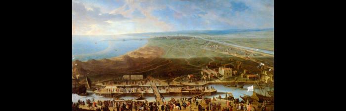
A garrison town until 1902, Gravelines was a strategic location, since it was the first Flemish town on the coastal border which separated the Kingdom of France from the County of Flanders, incorporated into the Netherlands under Charles V before being, during the ‘Grand Siècle’, the first fortified town in the interior line of the royal pré carré (the ‘square field’, an area of northern France enclosed within two parallel lines of fortresses). Of this strategic position, we are left with 10 km of surrounding walls (classified as historical monuments) and glacis; 3 km from Emperor Charles V (essentially the curtain walls and bastions); 3.6 km from Vauban (ravelins and counterguards), all surrounded by 4 km of glacis and the same of moats.
 
 
Alongside these passive elements were constructions whose aim was to strengthen the ramparts. These include magazine powders, bunkers, guardrooms and other strategic buildings.


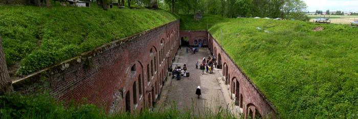
The master piece of these installations was what the people of Gravelines called the Arsenal.
 
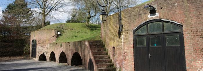
In fact, it was a collection of military buildings storing the weapons and ammunition as well as the tanks, bunkers (underground vaulted rooms used as protection from bombs) and a bread oven, dating from 1693 and in perfect condition. Today, these military buildings are open to the public in various forms.
The main powder magazine dating from 1742, flanking the centre of the Arsenal, today houses the Museum of Drawing and Original Printmaking, which has also taken up a few bunkers to increase the number of works on display to the public. The bread oven, installed in a bunker built sometime after 1528, is managed by the museum and can be freely accessed.
 
 
The soldiers tasked with surveillance were posted in the six guardrooms close to the bastions. Four of the six (Porte aux Boules, Rue de Dunkerque, Bastion du Moulin, Place de l'Esplanade) will undergo renovations. The newly acquired powder magazine located close to the Bastion du Roy will be used to create a cultural and educational trail of the guardrooms and other powder magazines, which will follow the fortifications around the city. Believing that having an army living in boarding houses was not the ideal situation for the civil population, Louis XIV asked de Louvois and Vauban to look into the possibility of building barracks for the soldiers. The plans went ahead and Gravelines was the site of Vauban-style barracks.
 
The Caserne Varennes (1737) which could house some 576 men of the rank and file (four cells of 144 beds) is impressively large (80 metres in length over three floors) with a facade that gives on to the Place de l'Esplanade, once used as a parade ground. At one time used as housing for the soldiers and a hospital during the First World War, and more recently social housing, the Caserne Varennes will be refurbished into eco-friendly housing. The Caserne d'Huxelles (75 metres long), built between 1793 and 1824 from a collection of blockhouses, was used as a resting place for soldiers forced to withdraw from the Caserne Varennes in the event of artillery fire. Employed as stables during the Third Republic, it will accommodate – after being refurbished – the Museum of Drawing and Original Printmaking, currently housed in the Arsenal powder magazine.
 
 
Between the two barrack buildings stands a tank with a volume of 1,420,000 litres, intended to provide the military and then the civil population with drinking water until 1945. Now empty and restored, it will be integrated into the museum.
 
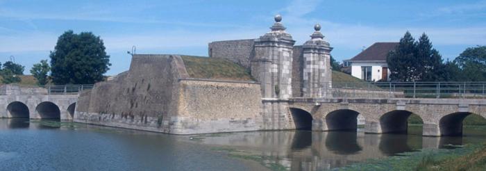
The Porte de Dunkerque (listed), also known as the Porte aux Boules, has been restored and redeveloped into a pedestrian leisure area.
Water has been returned and the area developed to welcome boats and pedalos for visitors to take a tour – guided if they so wish – around the fortifications offering an alternative approach to the city’s defences. To this end, the ravalins and counterguards have also been renovated and the waterways and walkways restored. 


Les Rives de l'Aa Tourist Office
 
11, rue de la République B.P. 139 - 59820 Gravelines - France
 
Tel: +33 (0)3 28 51 94 00
 
Fax: +33 (0)3 28 65 58 19


Hôtel de Ville
 
Place Charles Valentin - 59820 Gravelines - France
 
Tel: +33 (0)3 28 23 59 00


Individual and group guided tours:
 
Maison du Patrimoine 2, rue Léon Blum - 59820 Gravelines - France
 
Tel: 03.28.65.45.45
 
Fax: 03.28.65.58.19


Museum of Drawing and Original Printmaking
 
Tel: +33 (0)3 28 51 81 00
 
Fax: +33 (0)3 28 51 81 01


Events Regional Fortified Towns Day, last Sunday of April. Le Pardon des Marins (religious ceremony to bless boats before a long voyage), 15 August National Heritage Days, third weekend in September
 

Website of the regional tourism board for the Nord


> Return to results

Practical information

Address

59820
Gravelines
Tél. : 03.28.51.94.00Fax : 03.28.65.58.19

Weekly opening hours

Accessible toute l'année

Ambleteuse

Fort Mahon, Ambleteuse. Source: ©chateau-fort-manoir-chateau.eu

Fort Mahon in Ambleteuse, museum of the history of 1939-1945.


On the way between the Slack estuary and the village, visitors to this seaside resort will undoubtedly stumble across Fort Mahon, standing alone on a rocky outcrop. IT was designed by Vauban. Built between 1684 and 1690, probably on the site of the English battery of 1544, it consists of a tower accommodating a large ring-shaped casemate reinforced with a fausse-braye. The battery, flanked with two guardrooms and topped with an officer's pavilion, could contain 20 canons. The fort, which has a traditional appearance with its crenelated ramparts, has three floors of artillery. It was restored by Napoleon, and the battery was transformed during the German occupation.

Today, the fort houses an exhibition on the geographical history of the coastline.


Fort Mahon


Open on Saturday and Sunday from 3 pm to 6.30 pm in July and August and on Sunday from 3 pm to 6.30 pm in September and October. Group visits by appointment on +33 3.20.54.61.54


The Musée Historique 1939-1945 in Ambleteuse presents the noteworthy events of the second world war, from the campaign of Poland in 1939 to the capitulation of Japan on 2 September 1945, with explanations, maps, objects, uniforms and weapons, all of which are authentic and relative to this period of history. This museum is unique in France and complements the other establishments in the region. Most museums and sites in France only cover a precise period of the Second World War. Reports from the time and a film on the battle of Normandy are projected in a room which imitates 1940s' décor.


It took over thirty years of research all over the world to bring together the rich collections presented here. Of particular interest are the reconstitution of a street in Paris under the occupation and rare objects such as one of only two German regimental flags known in France.


Musée Historique 1939-1945

CD 940 62164 Ambleteuse

Tel.: +33 3.21.87.33.01

Fax: +33 3.87.35.01

Email: musee.39-45@wanadoo.fr


Open every day from 1 April to 15 October. Outside this period, open at weekends and national holidays. Closed in December, January and February.


Prices Adults: €6.90. Children (7-16 years): €5.00. Reduced price (war veterans, soldiers and students): €6.00. For groups, enquire at the museum.


Website of the regional tourist board for the Nord


Official website of the Musée Historique 3945


Quizz : Forts and citadels

> Return to results

Practical information

Address

CD 940 62164
Ambleteuse
Tel. : 03.21.87.33.01Fax : 03.87.35.01

Prices

Adultes : 6.90 € Enfants (7-16 ans) : 5.00 € Tarif réduit (anciens combattants, militaires, étudiants) : 6.00 €

Weekly opening hours

Fort Mahon : visite les samedi et dimanche de 15h00 à 18h30 en juillet-août et les dimanche de 15h00 à 18h30 en septembre-octobre. Visite de groupes sur rdv Musée : visite tous les jours du 1er avril au 15 octobre, les week-end et jours fériés en Hors Saison.

Fermetures annuelles

Fermé en décembre, janvier, février.

Le Portel Plage

Le Portel Plage, Fort de Couppes. ©J.Capez - License Creative Commons - Royalty-free

The three forts at Le Portel: Fort de l'Heurt, Fort du Mont de Couppes and Fort d'Alprech.

The town of Le Portel seeks to showcase its historical heritage through its three forts which, given their position on the coast, can help to develop its attractiveness for tourism.

Fort de l'Heurt was constructed in 1803 by order from Napoleon Bonaparte, who was 1st Consul at the time, as part of plans for a landing in England. “Heurt” comes from the noun "heustrière", which means "Oyster Island". Through contraction, this name became “heustre” and then “Heurt”. Plans for the structure were drawn up by Lieutenant Colonel Dode. The fort was commissioned in July 1804.
It was abandoned in August 1805 (when the camp at Boulogne was lifted). The fort is in ruins today, but its impressive bulk still braves the waves.

Seeking to take back Boulogne, which had been occupied by the English, Maréchal du Biez decided to build a fort. In 1550, the Peace of Capécure put an end to the war and the fort was abandoned. In planning for his invasion of England, Napoleon re-armed it. It was often used for quartering troops, especially during wartime. A semaphore was also set up.

Fort d'Alprech was built during the 3rd French Republic between 1875 and 1880 by Engineering General Séré de Rivières. There were bunkers for housing the personnel (some one hundred men), stores and an explosive magazine. The Alprech battery was armed with cannons and howitzers. It was operational during World War I and was occupied by the German army from 1940 to 1944. Fort d'Alprech was restored in 1999.


Le Portel Plage
Hôtel de Ville – 51 rue Carnot – BP 26 62480 – Le Portel
Tel.: +33 (0)3.21.87.73.73
E-mail: mairie@ville-leportel.fr


Website of the Regional Tourism Committee of the Nord Region


Quizz : Forts et citadels

> Return to results

Practical information

Address

62480
Portel Plage
Tél. : 03.21.87.73.73

Weekly opening hours

Accessible toute l'année

Mont-de-Marsan, Saint-Pierre-du-Mont and area

This is a useful guide for anyone interested in exploring the sites associated with the events of the two world wars that had a major impact on local life.


Due to the distance separating it from the front, the area of Mont-de-Marsan and Saint-Pierre-du-Mont was not particularly affected by the fighting of the First and Second World Wars.


Nevertheless, like many other towns in France, it felt the direct and indirect consequences of the conflicts, in particular with the departure of its infantry regiments in August 1914 and the arrival of the first German prisoners of war, and the establishment of the Demarcation Line in 1940.


In 1944, the bombing of the German airbase and the fighting on Bats Bridge would punctuate the road to liberation.


Without claiming to be exhaustive, this document seeks to chart the most significant events and the sites associated with them.


 Address and contact details:

 25, place du 6ème RPIMa - 40000 Mont-de-Marsan 

 Tel.: +33 (0)5 58 44 04 31


Website


Corps 2

> Return to results

Practical information

Address

25 Place du 6e RPIMA 40000
Mont-de-Marsan
05 58 44 04 31