Newsletter

Fort of Villey-le-Sec

Site du fort de Villey-le-Sec. Source : http://www.villey-le-sec.com

Part of the fortied town of Toul, Villey-Le-Sec is the only village in France within a modern French fort.

Following the defeat of 1870 and the annexation of Alsace-Moselle, the defence of the new eastern border was organised along fortification lines that formed defensive curtains, the product of the ideas of General Séré de Rivières. Two lines were built in the east: the defensive curtain of Hauts de Meuse (from Verdun to Toul) and Haute Moselle (from Epinal to Belfort). Two gaps designed to trap the enemy were also built between each line: Stenay (Meuse) and Charmes (Vosges). Apart from the advantage it had of providing geographic continuity with the curtain of Hauts de Meuse, Toul also served as an important crossing point on the main route between Paris and Strasbourg. The city also had an old fortified wall, which allowed it to quickly prepare for a defence of the city, and closed in the openings of the Haye forest and the Woëvre plain. Four forts were planned for construction in the short-term, marking out the four corners of the fortified twon of Toul : Ecrouves, Domgermain, St-Michel and Villey-Le-Sec. Villey-Le-Sec was charged with monitoring the openings of the Haye forest and was located on an elevated point 345m high on the right bank of the Moselle, alongside the ravine formed by this river as it runs through the Haye plateau.

By the time the planning of the fort began on 5 December 1873, the site had already presented major difficulties: the village occupied the site best-suited to the construction of the fort. Although it was suggested that the village be demolished, engineers decided to put the site to the best possible use in view of the urgent nature of the works: the demolition of the village would have also meant a delay in the construction of the fort and increased its cost. Nevertheless, work on the project began on 26 July 1875, even though the question of acquisitions had not been fully resolved. (The sites of the Nord and Sud batteries would not be acquired until October). What would follow was a long 4-year period of construction during which hundreds of workers would labour at a frantic pace. Given these lengthy horizons for completion and following an early crisis with our German neighbours, four redoubts were hastily built in Toul in late 1875 on points from which enemy artillery could bomb the heart of the town. In the sector of interest to us, the redoubts of Dommartin and Chaudeney (1km behind the fort of Villey-Le-Sec) were the state-of-the-art in military fortifications. The fort of Villey-Le-Sec was completed in 1879; only the Mougin turret, known as « G » and ordered on 14 August 1878 from the company Forges in Chatillon-Commentry was installed at a later date (1882). This turret required the construction of an inclined plane and railway track 203m long. The fort was now able to hold a garrison of 1301 men made up of 37 officers, 56 non-commissioned officers and 1208 soldiers, the manpower required to operate 36 ramparts, 8 mortars and 24 pieces of flanking artillery. Villey-le-sec was one of the more expensive forts in the fortification system. However, it was also an exceptional, unique complex; the inability to build the complex in the desired location meant that the whole village was fortified and protected by a surrounding wall and batteries. It is the only example of a village within a modern French fort.
Villey-Le-Sec is a surrounding fort made up of a Redan flanked by two batteries closed at the groove and two linking enclosures that have been hit by infantry fire. The complex is closed in by a square keep, a single-rampart stronghold. Built entirely of masonry covered in dirt, it was resistant to artillery used at the time. However, the useful life of the fort, as well as that of the Séré de Rivières system as a whole, suddenly came to an end in 1885 with the discovery of melignite and the development of new cylindrical-ogival shells capable of destroying forts made of stone. This was what would become known as the «torpedo shell» crisis. A series of experiments was thus carried out to strengthen the forts; the era of concrete and armour had just begun. In 1888, a directive would stipulate the first modifications to be made to the structures. As a result of these modifications, Villey-le-Sec was equipped with four barracks made of special concrete on 3 July 1890 : one in the keep, one in each battery and one in the redan. This cost 150,000 francs.
However, these first modifications were insufficient. At the instigation of the Haute Commission des Places Fortes (HCPL), created in 1899, a decision was made to embark on an ambitious programme to modernise the fort of Villey-Le-Sec, with work commencing on 11 July 1903. The former entrance of the keep was sealed and replaced with a new concrete barrack with an entrance at the end of the ditch. From winter 1905, other works, carried out by entrepreneur Benoît Estrade, would see the replacement of the caponniers of the keep with chests, the construction of concrete communication shafts and the building of armoured observation points. On February 7, delivery was taken of the redan's 75 turret (number 10). In 1907, the Nord battery took delivery of a 75 turret (number 13) and a machine-gun turret (number 25); the batteries and redan that flanked the ditches remained unchanged. Finally, from 1912, the fort would have an armoured battery for two 155 Court turrets. Although all of the substructures were completed, the turrets were never installed due to the declaration of war. The Sud battery was never modernised; it contains the features of the earliest forts. The fort of Villey-le-Sec is an exceptional complex not only due to its size, but also due to its originality in the sense that it surrounded a village. Owned by the council of the department of Meurthe-et-Moselle, this site, which is maintained with great professionalism by the Association La Citadelle, could become an important tourist destination within the schema for the development of the Boucles de la Moselle. It is for this reason that the department recently launched a definition study, which will enable it to develop a plan to develop the fort of Villey-Le-Sec. Naturally, the project has the support of the ministry of defence.
Hours: Open Sundays and public holidays to 15h from 1 May to 30 September Every day to 15h from 14 July to 15 August, except Monday at 15h. Groups welcome all year round, subject to reservation. Admission : Adults : ?5 Ambassadors of Lorraine : ?4 Children under 16 : ?2.50 Groups (more than 25 persons) : ?4 Contact : Monsieur Régis BERGER, Chairman Association La Citadelle 2 place de l'Eglise 54840 Villey-le-Sec 03.83.63.90.09 email :fort@villey-le-sec.com

> Return to results

Practical information

Address

rue du Fort 54840
Villey-le-Sec
03 83 63 90 09

Prices

Plein tarif : 6 € Tarif réduit : 3 €

Weekly opening hours

Du 1er mai au 30 septembre chaque dimanche et jours fériés

Indochina War Memorials

The memorial in Fréjus. © Ecpad

The memorial to wars in Indochina in Fréjus

- Télécharger la plaquette -
Following the signing of a French-Vietnamese protocol in 1986, the site for a cemetery in France had to be found. 
 
The site
The offer of a free plot of land swung the decision to accept the proposed town of Fréjus, especially given the place’s important role in the country's colonial history: the town was the site of a camp for soldiers leaving for Indochina. These links were evoked by the pagoda and monument and reinforced by the site's close proximity to the navy troops’ museum.
The graves
 
The bodies intended for burial in the Fréjus cemetery were men killed in action as well as civilians (the remains of 3,165 soldiers who were not killed in action having been reburied at a memorial on the military site of La Lègue).
Those killed in action fell between 1940 and 1945 and, for the most part, between 1946 and 1954. Additionally, the plan to build a cemetery was joined by the decision to create a history room. The site was named the “Indochina Wars Memorial”.
 
 
The memorial occupies 23,403 sq.m. of land. It was built within a circular perimeter 110 metres in diameter, the circle symbolising both the journey of life and the military zone inspired by tribal spiritual circles. The rows of recesses hold the bones of 17,188 named soldiers. An additional 62 bodies of soldiers previously buried at the cemetery in Luynes were moved here in 1975. The rows point towards the sea in the direction of the route to Indochina.
This orientation is also mirrored by an ascending pathway that leads to the highest point of the cemetery. The crypt holds the mortal remains of 3,152 unidentified victims in an ossuary. Exceptionally, some 3,618 civilians (including 79 unidentified) were also buried at the site in a columbarium built in the northwest part of the circular site. The cemetery entrance lies at the point in the circle tangent to the RN7 trunk road, between the history room and a pre-existing monument, erected in 1983 by a group of associations.
 
 
The history room
 
The learning room was renovated in 2009 and presents the history of French Indochina. It fulfils two objectives: to pay homage to the expeditionary corps soldiers and to offer visitors to the memorial, school groups in particular, information about the history of the French colonisation campaign and explanations on how the Indochina War started in the first place.
The permanent exhibition is a tribute to the soldiers fighting in Indochina during the Second World War (1939-1945) and the war of 1946-1954, represented by photos, illustrations and paintings. A documentary tells the history of Indochina from 1858 to 1954. The film is divided into three parts: Indochina, the pearl of the empire, 1858-1940; Indochina during World War II and the start of the war, 1940-1950; the war in Indochina from 1951 to 1954.
The exhibition is made up of key images showing soldiers in the French expeditionary corps in the Far East and Indochinese fighters. The human factor of the war is central to the history. The learning room contains a display of 74 canvases (1m x 2.5m) most of which show just one single photo.
 
 
The exhibition is divided into several sections:
 
1. French Indochina, from the conquest to becoming the pearl of the Empire
2. Indochina in the Second World War, 1940-1945
3. The return of France, 1945-1946
4. The beginnings of the First Indochina War (1947-1950) with the opposing forces, the French expeditionary corps, the Indochinese troops and presentation of the Viet Minh.
5. Manoeuvre warfare (1951-1953) with the development of major battles (Tonkin Delta, Hoa Binh, Na San, etc.).
6. The Battle of Dien Bien Phu (1953-1954)
7. The Geneva Conference and the repercussions of the war
 
Each panel is accompanied by one or more maps and photos.
 
 
Indochina War Memorials
Route Nationale 7 Route du Général Calliès 83600 Fréjus
Tel: 04.94.44.42.90
Open daily from 10 am to 5 pm
Closed Tuesdays
 
 
Source: MINDEF/SGA/DMPA
> Return to results

Practical information

Address

Route du Général Calliès 83600
Fréjus
04.94.44.42.90

Weekly opening hours

Ouvert tous les jours de 10h à 17h Fermé le mardi

Calvi Citadel

Calvi Citadel. Photo ECPAD

Ancient Genoese fortified town constructed in the 13th century in the south of Corsica, the citadel of Calvi is made up of a series of walls...

Ancient Genoese fortified town constructed in the 13th century in the south of Corsica, the citadel of Calvi is made up of a series of walls crisscrossed by narrow streets perched on the top of a chalky headland. Inside this very ancient citadel (also known as 'Ville-Haute') are several public and religious edifices: the former palace of the governor, the primatial church, the law court, the town hall and the college. At the entrance to the citadel visitors can read an inscription engraved by the Genoese: Civitas Calvi semper fidelis ('The city of Calvi, forever faithful').

> Return to results

Practical information

Address

Quai Landry 20260
Calvi

Weekly opening hours

Accessibilité toute l'année

Bonifacio Citadel

Haute ville de Bonifacio. Source : © GHIRARDI - License Creative Commons - Libre de droit

The citadel of Bonifacio was the first fortified town in Corsica.

While the citadel in Bastia evokes the long domination of the island by the Genoese, the citadel of Bonifacio can lay claim to being the first fortified town in Corsica. In the name of the Pope, Lord Boniface ordered the building of a fortress in 830 to which he then gave his name. It was later modified and enlarged to keep up with military technical advances. Situated to the west of the town high on a narrow plateau, the citadel was built to protect the southern coast from the incursions of the Saracens.

> Return to results

Practical information

Address

20169
Bonifacio

Weekly opening hours

Accessibilité toute l'année

Bastia Citadel

Bastia Citadel. Photo ECPAD

Bastia was founded in the 14th century and was the capital of Corsica throughout the period of Genoese domination until 1768.

Bastia was founded in the 14th century and was the capital of Corsica throughout the period of Genoese domination until 1768. On the high ground overlooking the entry to the small port of Marina di Cardo, the Genoese governor of the island, Leonello Lomellino, ordered the building of a fortress, or 'bastiglia' in Corsican, which became his residency, and was later occupied by his successors. The district of Terra-Nuova grew up around this citadel. The ramparts were added between 1480 and 1521. However the present appearance of the citadel and the other constructions forming the defences of Bastia date back to the time of Louis XV.

> Return to results

Practical information

Address

Route du front de Mer 20200
Bastia

Weekly opening hours

Accessibilité toute l'année

Fermont Fortification

Gros Ouvrage du FERMONT (A2). Source : http://www.la-ligne-maginot.com

Fermont Fort, located 5km east of Longuyon in the north of the Meurthe et Moselle, ranks with Simershof and Hackenberg among the Maginot line's largest fortifications.


Fermont Fort, located 5km east of Longuyon in the north of the Meurthe et Moselle, an area popular with tourists known as the "triangle of fire", ranks with Simershof and Hackenberg among the largest Maginot line fortifications to be open to the public.


This large fortification, built between May 1931 and February 1936 is part of La Crusnes fortified area. It is made up of seven combat blocks and two entrance blocks (for men and ammunition) linked by a network of over two kilometres of underground passageways.


In June 1940, under the command of Captain Aubert, the fort valiantly resisted several attacks by the Germans. On 17 June combat block no. 4 was attacked unsuccessfully. Another assault four days later against the entire fortification resulted in the loss of 80 soldiers (killed or wounded) on the German side and just one fatality and one serious injury on the French side. Although undefeated, the soldiers of Fermont Fort crew were obliged by orders from French command to surrender on 27 June 1940.


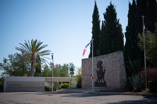
At the entrance to the fortification, a memorial in memory of the troops "delivered unbeaten to the enemy" is a just reminder that the majority of the fortifications on the Maginot line were still standing firm in the face of the enemy when the Armistice took effect on 25 June 1940.


The French Ministry of Defence, which owns the 27-hectare site, passed its upkeep, management and promotion to the Friends of Fort Fermont Fortification and the Maginot Line Association (AAOFLM) in 1975.

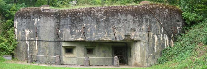
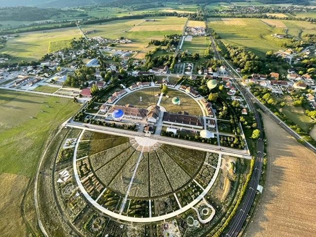
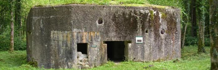
The site, which has been open to the public since 12 June 1977, is visited by an average of 20,000 people each year. The two-hour trip begins in front of the munitions entrance. Visitors enters a goods lift to travel 30 metres underground to the heart of the fortification, and are then directed towards the munitions magazine (M1), within which a museum depicting the daily life of the crew of the fort has been created. They then travel on a small train - an authentic shunter - to combat block no. 4. From outside the fortification, on the top of the structure, visitors can admire an impressive artillery bunker with 3 crenels measuring 75mm. A few hundred meters beyond lies no. 1 block with its 75mm turret.


After walking outside, visitors return inside the fortification. They board another small train to the barracks and electricity plant with its four 225 horsepower diesel generators, designed for use should the external electricity supply have been cut off. The conclusion to the visit is the exterior museum featuring a large number of artillery exhibits, including three turrets recovered from Brehain fortification (around 12km south-east of Longwy, on the plateau which faces Luxembourg).


During the summer, the association organises a number of events in addition to these visits. In August 2003 the Fermont Fortification was transformed into a giant exhibition venue for the work of contemporary artists from the region. It was also completely metamorphosed in March 2003 when a part of Olivier Dahan's film "Crimson Rivers 2: Angels of the Apocalypse" was filmed there with Christopher Lee, Jean Réno and Benoît Magimet. The Meurthe et Moselle Departmental Council was conscious of the need to preserve the fortification without damaging it. It commissioned a study into realising the potential of Fermont Fort from a specialised consultancy, which resulted in a credible, sustainable plan for the promotion of the site as a tourist attraction.
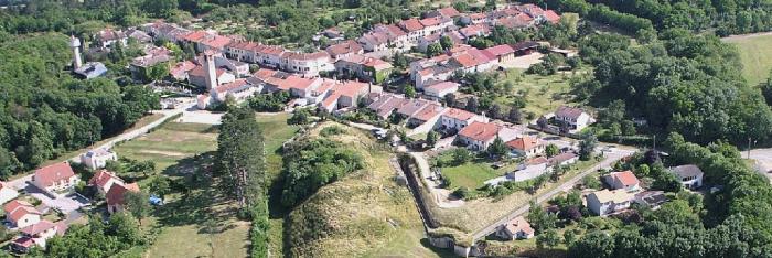


Fremont Fort

Contacts: Friends of Fort Fermont fortification and the Maginot Line association

9, rue Albert Lebrun 54260 LONGUYON

Tel: +33 (0)3 82 39 35 34

Fax: +33 (0)3 82 39 26 46

email :ligne.maginot.fort.de.fermont@wanadoo.fr

Administration office staffed: Monday - Wednesday 2pm to 6pm and Friday 9am to 12pm and 2pm to 6pm.


Please wear warm clothing and suitable shoes.

Allow two hours for your visit.


Opening hours and tours:

1 - 30 April Saturday, Sunday and bank holidays 2pm to 3.30pm

1 May to 30 June one single visit Monday to Friday at 3pm, Saturdays, Sundays and bank holidays 2pm to 3.30pm

1 July to 31 August every day from 2pm to 4.30pm

1 September to 3rd weekend in the month open every day, visits at 2pm and 3.30pm

3rd weekend in September to 31 October Saturdays and Sundays, visits at 2.30pm and 4pm

Open every day all year round for groups, by appointment with the administration office.

Entrance: Adults: €8, Children aged 7-12: €5 Group: €6 (30 people minimum)


Official Fermont Fort website


Fortweb website on European fortifications

> Return to results

Practical information

Address

54260
Longuyon
03 82 39 35 34

Prices

Adulte : 8 € Enfant de 7 à 12 ans : 5 € Enfant de moins de 7 ans : gratuit Groupe à partir de 30 personnes: 6 € par visiteur Groupes de moins de 30 personnes: forfait de 180 €

Weekly opening hours

http://www.ligne-maginot-fort-de-fermont.asso.fr/

Fort la Latte

Vue générale du fort. Source : ©Llorenzi - License Creative Commons - Libre de droit

Built in the 13th century, Fort La Latte...

This castle was built in the 13th century on a rocky headland by the famous Breton Goyon-Matignon family.

Two drawbridges cross the crevasses that separate the castle from the mainland. Due to its strategic position, over the years the castle has seen many interesting times. Du Guesclin laid siege to it in 1379. During the troubles associated with the Catholic League the buildings were largely destroyed by fire, with only the keep resisting the attacks. It was a very badly damaged castle that attracted the interest of Louis XIV. Garangeau was charged with converting it into a coastal defence stronghold (between 1690 and 1715), thus ensuring its survival. The old feudal castle underwent many changes, the chapel was rebuilt in the early 18th century and the furnace for heating canon balls dates from 1793. During the 19th century, Fort La Latte was gradually abandoned until it was staffed by a single guard. It was decommissioned in 1890 and sold two years later. In 1931, it was classified as a historical monument and restored.
Access By road: From Rennes - N12 E50 Lamballe - Follow Cap Fréhel on the D768, D13 and D34 Train: Lamballe (30 Km) Air: Dinard-Pleurtuit (30 Km) Tours The castle is open every day: - 11 April to 30 September from 10am to 12.30pm and from 14h30 to 18h - October 1 to April 10 during school holidays, Saturdays, Sundays and public holidays from 14h30 to 18h The castle is closed the rest of the time Contacts Tel.: +33 2 96 41 40 31 email :Flalatte@aol.com

> Return to results

Practical information

Address

22
la latte
02 96 41 40 31

Prices

Plein tarif: 5,10 € Tarif réduit: 4 €

Weekly opening hours

Du 1er avril au 30 septembre: de 10h30 à 12h30 et de 14h à 18h. Du 8 juillet au 28 août: de 10h30 à 19h.

Fermetures annuelles

Fermé le 25 décembre et le 1er janvier

Fort Penthièvre

Le Fort Penthièvre. Source : ECPAD

The purpose of Fort Penthièvre was to watch over the 15 km of beaches suitable for landing...

Fort Penthièvre is located at the base of the Quiberon peninsula. It was once called the Palice headland and was responsible for controlling access to the peninsula. Most importantly, it overlooks the 15 km or so of the Penthièvre beach, which is suitable for landing. Several forces had indeed landed there over the centuries: the Dutch in 1674 and the English in 1746. It was the pillaging of the peninsula by the latter which raised awareness of the vulnerability of its defences. In 1747 the construction of a fort was approved. This was to take the form of an enormous bastion built on a rocky promontory, blocking the only access to the peninsula. At this point, the lagoon bar was only a few dozen metres wide. During the Revolution, Fort Penthièvre would become a battleground of violent confrontations: 6,500 royalists, landed from the English fleet, seized it in an attack on 27 June 1795. It was recaptured by General Hoche's troops on 20 July. Left more or less abandoned, Fort Penthièvre was modernised and reinforced from 1800 onwards, under the impetus of the engineer General Marescot and on the orders of Bonaparte. In 1917 the fort was used as a prison for German soldiers. They carried out resurfacing work on the road. In 1933, it was entrusted to the navy and then fell into disuse. During the Second World War, it was occupied by the Germans and incorporated into the Atlantic wall. It housed various blockhouses, but was mainly used by the infantry. In July 1944, some resistance fighters were tortured and buried alive there. A pillar mounted on a Cross of Lorraine stands there in memory of them. Nowadays, Fort Penthièvre is a training base for the land army.

This historic monument, property of the Ministry of Defence, was included in a Culture and Defence protocol signed on 17 September 2005. Click here to see the list of other buildings ...

> Return to results

Practical information

Address

56
penthievre

Weekly opening hours

Seuls les espaces extérieurs sont accessibles

Saline royale d'Arc et Senans

Vue panoramique. Source : http://www.salineroyale.com/

The Royal Saltworks of Arc-et-Senans, the architectural masterpiece of Claude-Nicolas Ledoux, was used as an internment camp for Gypsies...

Internment of the Gypsies

In May 1941, the Feldkommandantur for Besançon decided to apply the decree passed on 4th October 1940 forcing travelling people in the occupied zone to be held together in internment camps. This measure was initially aimed at those in the Belfort, Doubs, Haute-Saône and Jura areas. It was then extended to cover those in the Côte-d'Or, Haute-Marne, Saône-et-Loire and Ain Departements. Thus, on 24th June 1941, the first travellers from Belfort were sent to the Châtelain and Châtelaine forest houses belonging to the Chaux estate, 22 km from Dôle. But this location quickly proved unsuitable. Insufficient accommodation and water that was unfit to drink caused the German authorities to transfer the Gypsies to the Arc-et-Senans Saltworks on 1st September 1941.
Built by architect Claude Nicolas LEDOUX, and owned by the Doubs Departement since 1927, the Royal Saltworks at that time was in a very poor state of repair despite initial restoration work carried out between 1930 and 1936. Among other things it had already been used as an assembly centre for Spanish Republicans between February and October 1939, before being requisitioned by the French Army during the Phoney War. The Germans then took possession of the place during the first half of 1941, until their departure. Until 15th May 1942, the status of the Arc-et-Senans camp, run by four Customs Officers, was that of an assembly centre. In effect, this meant that the Gypsies, grouped into whole families, could leave the camp area, through the use of exit passes. This period was also notable for the absence of common buildings which meant that the travelling people had to live by their own means. Thus, in order to support their families, some adults went to work in neighbouring businesses such as engineering firm UMAS (Union métallurgique d'Arc-et-Senans) or the Todt organisation. In addition, the sanitation was appalling; the showers were unusable, the toilets did not work and there were inadequate fresh water supplies... The lack of hygiene gave rise to diseases such as scabies, and many gypsies had to be transferred to the hospitals in Besançon for treatment. Meanwhile, an excessive number of escapes and exit passes that were too freely issued led to many complaints from the inhabitants of Arc-et-Senans. And on 15th May 1942, the order was given for the Royal Saltworks to become an internment camp. The changes were radical; people were no longer permitted to leave and as a result some hitherto absent facilities were rapidly installed. These included soup-kitchen style catering facilities, as well as an infirmary and a school able to take the 58 children registered at the camp. Despite these transformations, the Gypsy population still lived in difficult conditions. A report issued by the Camp Governor in August 1943, revealed that of the 185 internees, 44 suffered from skin complaints: infected wounds, abscesses, varicose ulcers, etc. Furthermore, the escapes continued. This undoubtedly led to the closure of the camp at Arc-et-Senans on 11th September 1943 and the transfer of the Gypsy families to the Jargeau internment camp in the Loiret region. This dramatic episode in the history of the Royal Saltworks has not been forgotten. On 11th and 12th March 1999 - as part of a major event entitled "A Look at Travelling People", organised by the Institut Claude Nicolas LEDOUX - a seminar was held at the Royal Saltworks on the theme "The Arc-et-Senans internment camp: its part in the discriminatory treatment of Gypsies". Finally, on 9th April 1999, a commemorative plaque was placed at the entrance to the Saltworks in tribute to the interned families.


Saline Royale Institut Claude-Nicolas Ledoux Département Tourisme et Publics 25610 Arc et Senans Tél.: + 33 (0)3 81 54 45 45 Fax: + 33 (0)3 81 54 45 46

> Return to results

Practical information

Address

Avenue de la Saline 25610
Arc et Senans
03 81 54 45 45

Prices

Adulte: 7,5 € Jeunes de 16 à 25 ans: 5 € Enfants de 6 à 15 ans: 3,5 € Gratuit : Enfant (- de 6 ans)

Weekly opening hours

De novembre à mars: 10h à 12h et 14h à17h Avril, mai, octobre: 9h à 12h et 14h à 18h Juin et septembre: 9h à 18h Juillet et Août: 9h à 19h

Fermetures annuelles

Fermé le 25 décembre et le 1er janvier

Hirson

Un des blockhaus d'Hirson. Source : http://fortifs.over-blog.com/


The Hirson Blockhouse line.


In the forest of Saint-Michel-en-Thiérache, near Hirson, there is a line of blockhouses built starting in 1936 and which were not part of the Maginot Line. Along the Belgian border, they form the connection between the fortifications of Maubeuge and those of the Ardennes. At first, only block shelters were built.


In 1940, although not yet completed, they provided support for two lines of combat positions: the front line – Ligne Principale de Résistance (LPR – Main Line of Resistance), and the rear line – Ligne d'Arrêt (LA – Stop Line), where the reserves in charge of the counterattack were located.


An anti-tank ditch and a network of anti-personnel barbed wire rounded out this double line.
The LPR and the LA contained imposing blockhouses equipped with cannons and machine guns.


On 18 May 1940, the Germans slipped between these two lines and took control of these positions.


A marked forest path is being set up. Furthermore, there is currently a project for a monument commemorating the fighting. Once the project is completed, some sites will accessible by car and hikers will be able to enjoy marked trails with explanatory signs for understanding the sites.


> Return to results

Practical information

Address

2500
Hirson
08 99 23 45 79

Weekly opening hours

Accès libre