Newsletter

The Bellanda Tower

The Bellanda Tower. Source : http://www.nicetourisme.com

Located in the commune of Nice, the Bellanda Tower guards over the Baie des Anges, in the south of the castle grounds.

Located in the commune of Nice, the Bellanda Tower guards over the Baie des Anges, in the south of the castle grounds.

A medieval defensive structure built on the site of an ancient acropolis, in 1825 it was converted into a belvedere. Berlioz is said to have composed his “King Lear” overture there in 1831.

Until 2006, the tower housed the naval museum, which is currently closed.

Bellanda Tower gallery

Colline du Château

Tél: 33 (0) 497 13 23 95

Open 10 am to 6 pm, except Sundays and some bank holidays. Free admission.


Nice Tourist Office


Quiz: Forts and citadels

> Return to results

Practical information

Address

Place du 8 mai 1945 parc du château 06300
Nice
04 97 13 23 95

Weekly opening hours

Du 1er avril au 31 mai et du 1er au 30 septembre:de 8h à 19h. Du 1er juin au 31 aout: de 8h à 20h. Du 1er octobre au 31 mars: de 8h à 18h

Cantigny

Plaque – Detail of the Monument to the US 1st Division. Source: www.usmilitariaforum.com

The Battle of Cantigny in May 1918 was the first major American battle in the Great War.

The Battle of Cantigny, which took place from 28 to 31 May 1918, remains extremely important in the history of the United States as it was the first major American battle in the Great War.

The Battle of Cantigny helped to contain the German offensives during the spring of 1918, giving newfound confidence and morale to the Allies and demonstrating the American soldiers’ fighting skills. General John J. Pershing wrote, "It was a question of pride for the American Expeditionary Forces that the division’s troops, in their first battle... should display the moral strength and courage of the veterans, holding on to land taken and refusing to let the enemy take the slightest advantage".

Over 1,000 American soldiers were put out of combat during this battle and 199 of them died. At Cantigny, the 1st Division began a series of American successes, powerfully amplified by the heroic position of the 2nd and 3rd US Divisions along the Marne a few days later. With nearly one million Americans in France at the time, the Allies’ morale was about to change, from a defeatist spirit to the certainty of victory soon to come. Cantigny was the first battle of the US 1st Division (now known as the 1st Infantry Division) which was again to make a name for itself in 1944 during the attack on Omaha Beach in Normandy on 6 June.

Many famous Americans fought at Cantigny, including George C. Marshall, Army Chief of Staff during World War II and later Secretary of Defence and the Secretary of State who implemented the Marshall Plan. Robert R. McCormick, owner of the Chicago Tribune who changed the name of his property to Cantigny when he returned to the United States. Upon his death, the property was transformed into a park open to the public in keeping with his last wishes; a foundation that bears his name was set up along with a museum dedicated to the history of the 1st Division from 1917 to the present, in Wheaton, Illinois. There are several monuments in Cantigny, in the Somme department, that serve to remind us of their exploits. A small private museum houses vestiges of the battle and can be visited by appointment.

"Pays de Parmentier" Tourist Office
5 Place du Général de Gaulle 80500 Montdidier
Tel.: +33 (0) 322 789 200 Fax : +33 (0) 322 780 088
Mail: ot-montdidier@orange.fr


Somme Somme Tourism Committee

“Pays Parmentier” Tourism

 First Division Museum

La Somme 14-18

> Return to results

Practical information

Address

5 Place du Général de Gaulle 80500
Montdidier
Tél : +33 (0) 322 789 200Fax : +33 (0) 322 780 088

Weekly opening hours

Accessible year round

Fort de Bron

The caponier. Source: Association of the Fort de Bron

This fort was responsible for preventing any enemy from crossing the heights of Chassieu or St-Priest and advancing towards Lyon.

It was responsible , thanks to the weaponry it contained (155 mm and 120 mm artillery pieces - 220 mm mortars) for preventing any enemy from crossing the heights of Chassieu or St-Priest and advancing towards Lyon, or setting up their own canons, which would then have been able to bomb the town. Trapezoid in shape, which is a characteristic of polygonal fortifications, the length of its perimeter was protected by a dry moat, which prevented the central structure from being surrounded by an infantry attack. Its buildings were covered with a mass of earth in order to absorb the effects of projectiles (an anti-impact layer). In the event of war, its garrison was increased to 841 artillery and infantrymen. More than 1500 m² of stores of various kinds housed provisions and munitions, food supplies, fuel and equipment etc.

History: Advances in artillery quite rapidly rendered this type of fortification obsolete and unsuitable. Nevertheless, the deterrent factor of any fortress could never be totally removed. It remained partly armed up until 1914. After 1920, it had only a logistical role for the nearby air base. It would be occupied by German troops in 1942, and finally given to the urban community of Lyon (la communauté urbaine de Lyon or COURLY) in 1975, to be used as a support building for the enormous water reservoirs. The town of Bron uses it for storing council equipment, for which the COURLY has granted a long lease in return for a modest rent.
The Association of the fort de Bron, created in 1982, brings together all the people and associations who want to contribute to the development, improvement and running of the place. Its administrative committee, with two permanent elected officers from the BRON district, defines the work that needs to be done and participates in the research work on future projects carried out by the council. A sports track and circular walk have been created. A long-term programme is planned for the renovation and conservation of the Fort: access to most of the moats, making some of the rooms in the Fort available for public use and the temporary opening of part of the interior for cultural, community and theatrical events.
The association is particularly keen to promote the historical heritage of this example of military architecture from the end of the 19th century. On the first Sunday of every month it organises free guided tours of the Fort and its museum, from 1.30 to 4.30 pm in winter and 2 to 5 pm in summer. It also organises occasional tours for associations and schools (requests to be addressed to the cultural department of the mairie).
It takes part in Heritage days and holds an artwork exhibition on the first Saturday and Sunday in October. The Fort de Bron belongs to the fortified defence system set up around Lyon after the war of 1870, at the instigation of General Séré de Rivières, who was responsible for fortifications on a national level. One room in the Fort bears his name. A museum is in the process of being established, with new documents and photographs from the period, as well as a visual display showing the different parts of the fort.
Fort de Bron Avenue Maréchal de Tassigny 69500 Bron Association du fort de Bron Bt 74 Maison des sociétés square Grimma 69500 Bron Tel: + 33 (0)6 60 65 25 23 E-mail: chaandre@numericable.fr

> Return to results

Practical information

Address

Avenue Maréchal de Tassigny 69500
Bron
Tél. : 06 60 65 25 23

Weekly opening hours

tous les premiers dimanches de chaque mois en période d'hiver de 13h30 à 16h30 et en période d'été de 14h à 17h, en après midi.

Fort de Villiers

Postcard of the fort Source: Association de Sauvegarde du Fort de Villiers

Fort de Villiers is a witness of the fortifications of Paris and the history of the Third Republic.

"Bridgehead on the Marne" (Noisy-le-Grand - 93) 


1871.

The first ring of forts built with the purpose of protecting the capital from the enemy did not prevent the defeat of 1870.

 
In the space of a few weeks, Bismarck's troops had surged into Paris, the Empire's armies had surrendered, Napoleon III had been taken prisoner, and the armistice, signed in January 1871, led to Alsace-Lorraine being annexed to the German Empire. 
 
On 21st March 1874, the project of the army commission was adopted at the National Assembly, by 386 votes to 191.
 
The bill of 27th March 1874 concerning the building of new forts around Paris authorised the Prime Minister, Adolphe Thiers, to erect a fortified "ring" around Paris as part of a comprehensive fortification project, implementation of which was entrusted to General Séré de Rivières, at the time Director of Engineering:
 
"For this we will need to occupy, probably between Noisy-le-Grand and Villiers, a position creating a bridgehead and at the same time covering the waterways of the bridges at Brie, Nogent, Joinville and Champigny.
 
The fort constructed at this point will be the most effective way of protecting the perimeters of the Fort de Nogent, and will be connected to the Chelles-Vaujours line." 60,000,000 old francs (one Germinal Franc = 1.42 euros in 2007) were allocated to the works and purchase of land.
Between 1874 and 1881, 18 forts, 34 defensive batteries and 5 redoubts were built around Paris The eastern part of this defence system was made up of the Fort de Villiers, which today falls within the town of Noisy-le-Grand (1878-1880), the Fort de Champigny (1878-1880) and the Fort de Sucy (1879-1881).
 
An implementation order of 31st December 1877 set out the provisions for the construction of Fort de Villiers in the town of Noisy-le-Grand (at the time in the Seine et Oise département), originally named the "Bridgehead on the Marne".
 
Constructed on the heights above the banks of the Marne at an altitude of 111 metres, the fort was intended to prevent the enemy from establishing itself there. The works commenced in 1878 and were finished in 1880.
 
The plan marking the boundary, the access zone and the remarkable polygon was approved by the Minister for War on 18th October 1882 and officially recognised and approved by decree on 10th September 1883. 
 
 
The budget for the construction of Fort de Villiers had been estimated at 11,000,000 francs for the work and 1,000,000 francs for the purchase of land. 
 
 
The Fort de Villiers today
 
Property of the Ministry of Defence and afterwards of the public EPAMARNE institution, in July 2001 the latter donated it to the town of Noisy-le-Grand.
 
The area created within the current perimeter of the Fort de Villiers covers approximately four hectares - originally seven hectares - on the edge of the A4 motorway in the town of Noisy-le-Grand, in the Montfort district, on the edge of the town of Villiers-sur-Marne, to the south of the Seine Saint-Denis département.  
 
Some sporting associations were housed there until December 2007. 
 
Since then, access to it has been prohibited by a municipal danger notice, principally because of the state of the access walkway and trees that died or became unstable following the storm of 2000.
 
The Fort de Villiers is one of the witnesses of the fortifications of Paris and the history of the Third Republic, from Louis Adolphe Thiers, President of the Republic and head of the executive from 1871 to 1873, to Patrice de Mac-Mahon, President of the Republic from 1873-1879.
 
It also bears witness to the developments in military architecture and the transition from bastioned architecture to underground architecture.
 
The aims of the Association de Sauvegarde du Fort De Villiers (Association for the Protection of the Fort De Villiers or ASFV), created in March 2008, are to promote initiatives designed to improve awareness of the fort, in support of the historical and photographic archive documents and the project for its conservation and improvement. 


Fort de Villiers

Avenue Paul Belmondo

93160 Noisy-le-Grand

E-mail : contact@asfv.eu


Visits Warning! Fort de Villiers is not open to visitors. The site is dangerous and is not protected by security (entry is prohibited). 


Contact the Mairie in Noisy-le-Grand to request access.


Bibliographical sources Annals of the National Assembly.  Government bills, proposals and reports. 1874 List of the law bills of the French Republic. 1874


Fort de Villiers


Quizz : Forts et citadelles


> Return to results

Practical information

Address

Avenue Paul Belmondo 93160
Noisy-le-Grand

Weekly opening hours

Le fort n'est pas ouvert au public.

Email : contact@asfv.eu

The fortifications of Saint-Martin-de-Ré

Vue aérienne de Saint-Martin-de-Ré. Source : GNU Free Documentation License

In 1681 Vauban strengthened the island's defences by constructing a citadel and a fortified castle.

The l'île de Ré, opposite La Rochelle, was subjected on several occasions to attack from British soldiers. Conscious of the need to protect access to La Rochelle and Rochefort, in 1681 Vauban started strengthening the island's defences by building a citadel and fortified castle at Saint-Martin-de-Ré, on the North coast.

Built on the site of a fortress where construction work had started in 1627, the square-shaped citadel occupies the eastern part of the town. Its defensive system comprises four bastions, three demi-lunes and a counterguard, surrounded by a moat and a covered walkway. It contained an arsenal, food and powder stores, barracks and officers' accommodation. The citadel opens on to the sea via a small fortified port. From 1873 onwards it became a stop-off point for penal colony prisoners on the way to New Caledonia until 1897 and later to Guyana until 1938. Today it remains a prison for more than 400 detainees and is not open to the public.
An example of Vauban's first system adapted to suit a flat site, the construction was accompanied by an enormous fortified enclosure capable of accommodating the island's population of some 16,000 inhabitants, as well as their livestock, and of storing food supplies and forage in the event of enemy attack. In an arc on the land side, there are bastions, orilloned half- bastions and a counterguard. Two monumental gates, the Porte Toiras and the Porte des Campani form the access points. Also surrounded by a moat and a covered walkway, it is in addition encircled by an open-plan glacis, sloping outwards from the ramparts within canon-firing range.
Saint-Martin de Ré Tourist Information Office 2, quai Nicolas Baudin Ilot du Port - BP 41 17410 Saint-Martin-Ré Tel.: + 33 (0) 5 46 09 20 06 Open from 01-07 to 31-08, from 10 am to 7 pm, Monday to Saturday and from 10 am to 1 pm and from 3 pm to 5 pm on Sundays and Bank Holidays from 01.06 to 30.09: Monday to Saturday from 10 am to 1 pm and from 2 pm to 6 pm and from 10 am to 1 pm on Sundays and Bank Holidays In May: Monday to Saturday from 10 am to 1 pm and from 2 pm to 6 pm and from 10 am to 12 pm on Sundays and/or Bank Holidays In April and during school holidays: Monday to Saturday from 10 am to 12 pm and from 2 pm to 6 pm and on Sundays and Bank Holidays from 10 am to 12 pm from 01-10 to 31-03: Monday to Saturday from 10 am to 12 pm and from 2 pm to 6 pm

> Return to results

Practical information

Address

Cours Vauban 17410
Saint-Martin-Ré

Prices

Visite guidée Plein tarif: 6 € Tarif réduit: 2,50 € Groupes (+ de 20 personnes): 5,5 €

Weekly opening hours

Accès libre toute l’année. Visite guidé sur réservation le mardi et jeudi à 10h30 pendant les vacances scolaires.

Camaret-sur-Mer Vauban tower

Le Sillon - vue prise de la pointe du Grand Gouin, Camaret-sur-Mer. Source : ©Michael Rapp - License Creative Commons - Libre de droit

The aim of the Vauban tower was to defend Brest harbour from enemy invasions and pirates.


The tower was built close to Notre Dame de Rocamadour chapel, at the end of the breakwater which protects Camaret port, at the entrance to the Crozon peninsular. It was part of a complex strategy designed to defend Brest harbour from enemy invasions and pirates.


The tower was built between 1693 and 1696 under the supervision of the engineer Jean-Pierre Traverse. It has four floors (basement, ground floor and two upper floors) and is 18m high to the roof.

The basement, with trap door access, was used to store food and powder.

A spiral staircase leads to the upper floors which housed the guard room and accommodation.

The hexagonal tower features arrow slits for defensive purposes. Acute angles of attack mean that projectiles could be deflected. It is also known as the Tour Dorée (Golden Tower) because the base is finished with a coating made from crushed bricks.


The tower is flanked by a low, semi-circular battery with wide embrasures for eleven canons and a defensive guard room. A second guardroom was later built on the site of the shot furnace. A beam drawbridge provided access to the site and the footbridge to the tower.


In June 1694 the tower, as yet unfinished, suffered its first attack, from the Anglo-Dutch Augsbourg League, whose aim was to take control of Brest Harbour. The tower was armed with just nine canons and three mortars, but the effectiveness of its defensive system was clear immediately. The 1,500 coalition men who had landed on Trez Rouz beach in front of Camaret were routed in a few short hours, suffering heavy losses.


Tourist office
15, quai Kléber BP 16 29570 Camaret-sur-Mer
Tel.: +33.(0)2.98.27.87.22


Open high season (01-07 to 31-08) from 10am to 12 noon and 2pm to 6pm every day.
Low season (April - September): 2pm to 6pm Tuesday to Sunday


Entrance
Adults: €3
Reduced rate (students, job seekers, people on income support, etc.): €2
Free entry for children under 12 (except groups)

Vauban association

Major Vauban sites network

> Return to results

Practical information

Address

Quai Gustave Toudouze 29570
Camaret-sur-Mer
02 98 27 94 22

Prices

Plein tarif: 3 € Tarif réduit: 2 € Gratuit : Moins de 12 ans

Weekly opening hours

Avril à octobre: 14h-17h Juillet et août : 10h-12h / 14h-18h

Fermetures annuelles

Fermé le lundi d'avril à octobre

The Internment and Deportation Memorial at Royallieu

Carte postale de Royallieu. Source : http://www.11mai44.info/

The memorial, a historic place, is a reminder of the events that took place at the site of the former Royallieu internment camp.

Last February a memorial was opened on the site of the former Royallieu internment camp. As place of history, it is a reminder of events, setting them within the context of the Second World War and the Nazi policies of repression and extermination. As a place of remembrance, it pays homage to all those who were detained there before being deported to Germany and Poland or shot as hostages. In 1939, the Royallieu barracks near Compiègne in the Oise département was used as a military hospital before being converted by the Germans in June 1940 into a camp where they brought French and British prisoners of war.

In 1941, they turned it into a " permanent concentration camp for active enemy individuals" under the official name of Frontstalag 122, which became a "German police detention camp" by virtue of decree on the 30th December 1941. Resistance fighters, political and unionist militants, Jews, civilians arrested in raids and foreigners etc. - more than 45,000 of them would pass through there before being deported to Nazi concentration and extermination camps. "I got out of the last departure and really hope not to be in on the next one. I am here with some really nice, good people: communists, Gaullists, royalists, priests, aristocrats and country folk - it's an extraordinary mixture", the poet Robert Desnos, who was interned on the 20th March 1944, wrote to his girlfriend. A short respite. A death train took him away on the 27th April to Flöha en Saxe and he was to succumb to typhoid on the 8th June 1945 at Terezin. It was from the camp at Royallieu that the very first deportation train was to leave French soil on the 27th March 1942. It took over a thousand Jews to Auschwitz, as did the next one on the 5th June. A third convoy, consisting mostly of communist and unionist hostages, left Compiègne on the 6th July. Royallieu was thus to become a transit camp for detainees, for the most part political and resistance fighters, prior to their deportation.
A place for remembering Research carried out by the Remembrance of the Deportation Foundation at the History Department of the Ministry of Defence's archive office for victims of contemporary conflicts has allowed the identification of the departure of twenty-six large convoys, in addition to a dozen small convoys between 1942 and 1944. Including the first two convoys of deported Jews, this makes a total of forty convoys. Since the camp also served as a place for detaining hostages, other internees were shot in the surrounding forests once reprisal measures had been agreed. It is to all these people that the internment and deportation memorial is dedicated. This has just been built on part of the former camp by the town of Compiègne in partnership with the Remembrance of the Deportation Foundation, the Defence Department (Directorate of Memory, Heritage and Archives, SGA/DMPA), the Regional Council of Picardy, the General Council of the Oise, the Heritage Foundation and the Caisse des dépôts et consignations (a government body in charge of investing and lending public money). The historian and filmmaker Christian Delage created the journey through history. The architect and scenographer Jean-Jacques Raynaud designed the setting. The result is solemn, due as much to the materials used - glass, concrete and stone - as to the way the floors and walls in the three preserved buildings that remain out of the original twenty-five have been stripped back to their initial condition, and the use of sounds and images to set the scene. Opposite the entrance stands a wall to guide visitors towards the reception hall. Made up of a series of glass pillars bearing the names of all the deportees and internees of the camp at Royallieu identified to date, its purpose is to give the internees back their identities. It is through these names that visitors are introduced to the site. Around the buildings is what is today a garden of remembrance, as well as an exhibition area: plans of the internment camp, group photographs of the guards and written and recorded accounts accompany visitors as they retrace the history of the site.
The memorial provides two routes that are complementary to and inseparable from each other. One of them, the result of the hard work of historians, puts the history of the camp in context; the other encourages visitors to follow their own personal remembrance trail. The history is mapped out along a frieze running the length of the walls of the ten halls that form the tour. It covers in succession: the historic context, internment and the daily life of the camp, transportation on the deportation trains and forced labour and death in the Nazi camps. Documents and archive films illustrate the descriptions. Letters, photographs, drawings and recorded eyewitness accounts tell of life at Royallieu. In places, the images projected onto the walls and floors dominate the whole room. The remembrance trails themselves are an opportunity to meet the many witnesses, who tell of how they survived their passage through this transit camp. These accounts, in several different voices, demonstrate the wide diversity in the backgrounds of the detainees, their opinions and the conditions in which they were held. These men and women are constantly present: their names, their faces, their words and their written accounts remain with the visitor. The buildings are both exhibition halls and "exhibits" at the same time. The walls, floors and ceilings are all in their original condition: the tiles and lino have been removed, to reveal the original rough concrete that internees would have trodden; the false ceilings from the 1970's have been taken down to show the barracks' plastered ceilings; recent paint work has been scraped off to reveal the different layers of materials, colours and decoration beneath.
The words of witnesses The memorial provides many and varied sound recordings. Chosen carefully, some of them contribute in setting the scene. Broadcast all around the place, they are triggered automatically as they detect visitors' movement. Others are transmitted by an audio-guide, available to every visitor. In this way everyone can follow his own audio route, in his own language and at his own speed. The audio-guide can also be used to develop tours for specific groups - young children or the partially sighted - and themed tours etc. The words of the witnesses resonate around the place. They resound off the metal and wooden chairs in the garden and leap out at you as you pass through the corridors of the buildings. It is these different accounts, organised by theme, such as arrival at the camp, daily and social life, ways of surviving, solidarity, loneliness, leaving for Germany etc., that best tell the history of the camp. These sound montages have been created from documents in the huge audio-visual collection built up by the Remembrance of the Deportation Foundation and from new accounts recorded especially for the memorial. At times, the scenography calls on the emotions in a personal way, encouraging visitors to attune their feelings with those of the place itself and to remember rather then to discover. This is why, for example, on the floor in the barracks the positions where the beds would have been are marked using a single line to draw their outlines, extending up the walls to indicate bunk beds. The resulting impression of being cramped together is immediately apparent. In the same spirit, pictures of men and women are projected onto the walls very slowly, one after the other. Letters sent by prisoners to their families have been collected in two virtual albums that are projected onto two table screens, whilst at the same time being read aloud by actors. The tour ends in a room dedicated to the history of deportation, genocide and the punishment of criminals.
The contribution of the Defence Department Through the general administration department's Directorate of Memory, Heritage and Archives, the deputy minister for ex-servicemen awarded a grant of two million Euros spread over 2005 and 2006, as a contribution to the creation of this place of remembrance. In addition, the Defence Department, now the owner of the site of the former barracks at Royallieu, transferred the management of two hectares of land to the town of Compiègne and it is on this land that the Internment and Deportation Memorial was built.
Internment and Deportation Memorial Camp de Royallieu 2 bis, rue des Martyrs de la liberté 60200 Compiègne Tel. 03 44 96 37 00 E-mail: memorial@compiegne.fr

> Return to results

Practical information

Address

2 bis rue des Martyrs de la liberté Camp de Royallieu 60200
Compiègne

Prices

Plein tarif: 3 € Demi tarif: 1,5 € Gratuit : Anciens combattants et victimes de guerre, anciens internés, déportés, enfants (- de 6 ans), les groupes scolaires de l'Agglomération de la Région de Compiègne et les Centres aérés de la ville de Compiègne

Weekly opening hours

Tous les jours de 10h à 18h

Fermetures annuelles

Fermé le mardi

Montsec American Monument

Montsec American Monument. © GNU Free Documentation Licence – Royalty-free

Built in 1930, the monument commemorates the attacks carried out by the American Army in 1918 to take the St. Mihiel salient.

Located some twenty kilometres southwest of St. Mihiel Cemetery in Thiaucourt (Meurthe-et-Moselle department) and some fifteen kilometres from the town of St. Mihiel, the Montsec American Monument, built on a 270-metre hill, overlooks Madine Lake.

Produced by sculptor Egerton Swarthout, the monument, built with Euville limestone in 1930, commemorates the attacks carried out by the American Army from 12 to 14 September 1918 and from 9 to 11 November 1918 to take the St. Mihiel salient.


A large walkway leads to an open-air colonnade made up of fluted Doric columns supporting an entablature bearing the names of the towns, alternating with laurel wreaths.


At the centre of the colonnade is a bronze map illustrating the location of the St. Mihiel salient fronts. Damaged during fighting in 1944, the structure was restored four years later. Access to the monument is free.


Montsec American Monument Head toward Saint-Mihiel.

At Loupmont, continue toward Apremont-la-Forêt and then "Massif Fortifié de Liouville".


Montsec Town Hall

8 rue de l'Eglise - 55300 Montsec

Tel.: +33 (0)3 29 90 42 83

> Return to results

Practical information

Address

55300
Montsec
03 29 90 42 83

Weekly opening hours

Free access

Salins-les-Bains Fortifications

Fort Saint André. Source : http://www.salins-les-bains.com


While there are few traces of Marshal Vauban’s interventions at Fort Belin and the Bracon redoubt, Fort Saint André has preserved his indelible mark.


Comtois, rends-toi ! Nenni ma foi ! (Comtois surrender! Never, by my faith!) This motto is the pride of the people of Franche-Comté. People here never surrender to the enemy. For a long time, the enemy was the King of France.

Franche-Comté enjoyed a certain degree of freedom as part of the Holy Roman Empire to the east of the Kingdom of France. This was enough to whet the appetite of Louis XI, Henri IV, Louis XIII and, lastly, Louis XIV.


With the help of Sébastien Le Prestre de Vauban, the Sun King was able to bring it into his realm. Franche-Comté became French. The enemy did not disappear, he just changed nationalities. So Vauban got down to work, making the province an impregnable land.


In 1675, Louis XIV entrusted his brilliant military engineer, promoted to the rank of Marshal of France and Commissioner General of Fortifications, with the task of fortifying the principal strategic points in Franche-Comté. After Belfort, Besançon, Joux and Salins-les-Bains, he worked on three structures defending Salins, a Jura town nestled away in a steephead valley (geographical term designating a steep, narrow valley in a limestone plateau in the Jura) and economic heart of Franche-Comté due to the presence of salt mines, the precious “white gold”. While there are few if any remains of his interventions at Fort Belin and the Bracon redoubt, Fort Saint André has preserved his indelible mark.


All the constructions that Vauban had built starting in 1678 at the site of a small fortress from the first half of the 17th century are there:

  • the forward structure whose mission is to defend the entrance to the fort;

  • the monumental gate bearing the Sun King’s motto: “Nec pluribus impar” (not unequal to many);

  • the crenellated bastions with the wall-walk at the top;

  • two 65-metre long barracks where forty fully equipped holiday accommodations are now housed;

  • the powder magazine topped with an elegant ribbed vault and a lava tile roof, which is now a friendly pub;

  • the governor’s house, which is awaiting renovation;

  • the vast chapel topped with a roof lantern, which has long been abandoned;

  • the central courtyard with pleasant squares of lawn;

  • the holiday and conference environment that now fills the site.


From 1682 to the middle of the 19th century, this fortress served as a State prison. The men and women involved in the famous “Affair of the Poisons” that brought down Madame de Montespan were followed by prisoners locked up by the different regimes by “lettres de cachet” at the request of their families or for political, military or common law reasons, whether former nobles, defrocked priests, suspicious citizens, sans-culottes, Swiss or Spaniards.


Salins-les-Bains Fortifications


Office de Tourisme

39110 Salins-les-Bains

Tél. +33 (0)3 84 73 01 34


Fort Saint-André

Village Vauban 39110 Salins-les-Bains

Tél. +330(3) 84 73 16 61


Fort Saint André


> Return to results

Practical information

Address

39110
Salins-les-Bains
03 84 73 16 61

Weekly opening hours

Du 1er avril au 31 octobre

Fort Rapp-Moltke

Fort Rapp-Moltke. Source : http://julienviel.hautetfort.com/culture/

Inaugurated on 26 September 1874, Fort Rapp-Moltke was part of the fortified ring around Strasbourg.

The speed at which Strasbourg fell, on 28 September 1870, after 46 days of siege, prompted the German High Command, under the authority of General Von Moltke and Von Kameke, to formulate a defence plan for the Empire’s western borders that planned to turn the towns of Cologne, Metez, Thionville and Strasburg into fortified camps, protecting their perimeters by a ring of armed forts.

The defensive ring around Strasbourg

Strasbourg was thus protected by a ring of detached, half-buried, heavily fortified and armed structures, even before the construction of the new urban line of fortifications that would be started in 1876 after the commissioning of the first forts. The works began in 1872, under the direction of the engineering officers Hauptmann Stephan (Fort Rapp) and Volkmann (on the Rhine side in the northeast to pass over to Kehl on the right bank via the southeast).


Fort Reichstett (Moltke) was inaugurated on 26 September 1874. Eleven structures were built in Alsace covering a perimeter of nearly 35 kilometres and three structures around Kehl (in Germany) covering a perimeter of 18 kilometres. The line included forts with dry and wet ditches. The masonry, in dressed standstone from Vosges and bricks manufactured in Rust (Germany) and Achenheim (Alsace), puts these monuments in the Neo-Prussian style. Two to three thousand workers were employed, including Italian bricklayers.
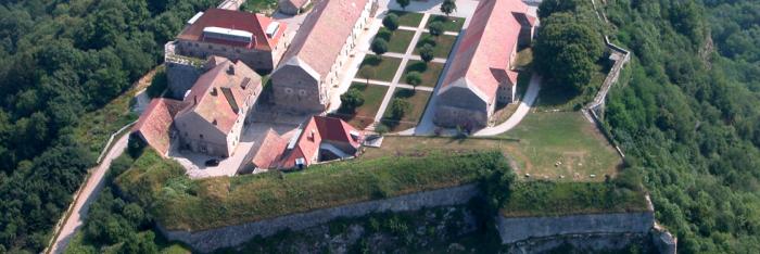
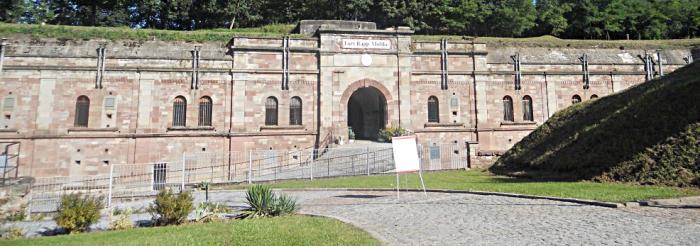


Fort Rapp-Moltke

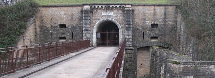
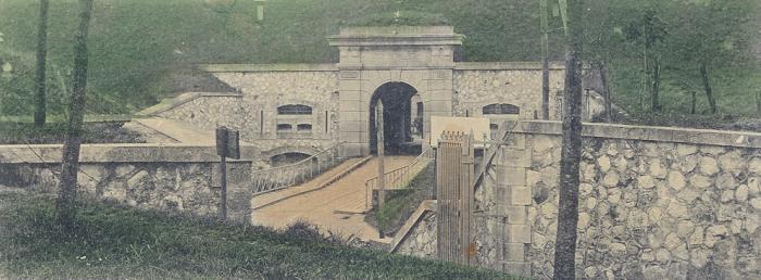
The outpost covered 4.5 hectares and was made up of some 220 rooms and facilities. The fort comprised: an entrance with a place of arms, guard house, large powder store and guard quarters during peace time; a dry ditch surrounding the fort fitted with a covered way supplemented by a barbed-wire fence; barracks on two levels housed the troops quarters and services (HQ, kitchen, bakery, infirmary, sleeping quarters, washing facilities, etc.) and were equipped with a defence system of the ditch by flanking; an entrance into the fort composed of a gate, draw bridge and reinforced door; a central corridor leading to the casemates; casemates composed of alarm rooms, powder stores, munitions assembly rooms, goods hoist for moving munitions into artillery positions at the top of the fort; front and side parapets surmounting the fort, reserved for artillery pieces.


The outposts were protected by: sheltered corridors, a reinforced observation turret made it easier to keep watch of the front; a double caponier above the front ditch, converted in 1885 to a front battery was built in the counyterscarp with a system of countermines and sewers completing the frontal defence system; adjoining batteries to the left and right. Each fort was defended by 18 cannons (90 to 150 and even 220 mm) in firing position; 18 reserve pieces of artillery in the interior courtyards (cannons and mortars). The short-range defence was assured by 90-120 mm cannons which were later replaced by Hotchkiss 37-mm revolver cannons and 53-mm rapidfire machine guns. The fort could hold 800 men (infantrymen, pioneers, artillerymen and guards) under the command of 15 officers.


An evolving system

In 1885, the discovery of picric acid and the manufacture of torpedo shells triggered a huge crisis in military constructions. High Command decided to take the artillery outside the fort to form the adjoining batteries, reinforce the top sections of the forts with “special concrete” and granite blocks, convert windows in the barracks into fire stands, turn the double caponier into a front-facing battery offering greater protection and equipped with revolver cannons, fit out the walls with counterscarps of metal gates and build the entrance via the ditch, install blast-proof doors at certain access points, and reinforce the fort’s defences with two marine artillery pieces, 150 mm on rails.

From 1890, intermediate structures were built between the forts to block up any gaps; these included infantry, artillery and munitions buildings to complete the defence system. In this year, the fort in Strasbourg lost its strategic importance due to the stronghold erected in Mutzig (1893-1914) that had the capacity for up to 6,500 men with artillery in turrets and armoured shields.

Between 1914 and 1918, the fort was used as a munitions and equipment store then a camp for Russian and Italian prisoners. Alsace-Lorraine was returned to France following the Treaty of Versailles and the site was integrated into the Maginot Line as a rear base for the 226th Infantry Regiment of Strasbourg and a rest centre for the fortress troops based in the fortifications along the Maginot Line along the Rhine. Marine artillery pieces were placed on top of the fort around 1937.


The Ney-Rapp intermediate structure occupied by the 155th Fortress Artillery Regiment, was damaged by an explosion in June 1940. From 1940 to 1944, the German army used the stronghold as a warehouse. It was occupied by the FFI and the first French and American troops during the Liberation. Between 1946 and 1968, the fort was used as a munitions store.

After being decommissioned, the site was allocated to the civil protection department of the French Ministry of the Interior. In 1993, the Friends of Fort Rapp Association was tasked with rescuing, preserving and restoring this military structure. After three years of work, the fort was opened to the public.


Fort Rapp-Moltke

Rue de Lorraine 67116 Reichstett

Contact: mjg.schuler@evc.net


Tourisme 67


> Return to results

Practical information

Address

Rue de Lorraine 67116
Reichstett

Weekly opening hours

Visites guidées d'avril à septembre. Tous les jeudis à 15h ainsi que les 2e et 4e dimanches du mois à 14h,15h et 16h30