Newsletter

Lieu de Mémoire au Chambon-sur-Lignon

?View leaflet   ? Page Facebook

A unique site dedicated to the history of the Righteous and the Resistance movements during the Second World War.

Pendant la Seconde Guerre mondiale, entre Haute-Loire et Ardèche, le Chambon-sur-Lignon et les villages alentours ont accueilli et aidé de nombreux réfugiés, la plupart juifs pourchassés dans une Europe sous le joug nazi. C’est pour transmettre les valeurs d’humanité et d’engagement qui ont permis ce sauvetage à grande échelle que le Lieu de Mémoire a ouvert en juin 2013.


Un Lieu de mémoire, d’histoire et d’éducation :


Le parcours historique s’organise autour des différentes formes de résistances : civile, spirituelle et armée. Il est complété par une salle mémorielle où des écrans tactiles permettent de visionner des témoignages de sauveteurs, réfugiés et résistants. Les outils multimédias facilitent la compréhension des événements, même pour les plus jeunes.


Le Service éducatif du Lieu de Mémoire propose toute l’année des visites et des ateliers pédagogiques adaptés aux différents niveaux scolaires. Pour les élèves, c’est l’occasion d’aborder la Seconde Guerre mondiale sous un angle différent. ?Catalogue pédagogique en lien


Sources : ©Lieu de Mémoire au Chambon-sur-Lignon - ©Luc Olivier – MDDT43

> Return to results

Practical information

Address

23 Route du Mazet 43400
Le Chambon-sur-Lignon
04 71 56 56 65

Prices

- Plein tarif : 5 € - Jeunes : 3 € / Scolaires : 2 € - Groupes : 3.50 € - Gratuité : moins de 10 ans - Pass/tarifs groupés éventuels : Carte ambassadeur, 10 €

Weekly opening hours

Toute l’année sur réservation pour les scolaires et les groupes Public individuel : 1er mars au 31 mai et 1er octobre au 30 novembre : du mercredi au samedi, 14h/18h 1er juin au 30 septembre : du mardi au dimanche, 10h/12h30 et 14h/18h

Fermetures annuelles

Fermé en décembre, janvier et février, sauf pour les scolaires et les groupes. Office de tourisme - 2 Route de Tence / 43400 Le Chambon-sur-Lignon - 04.71.59.71.56

Porh Punz Battery Gavres

Le fort de Porh-Puns (le port du puits, en breton). Source : Ouest-france

Located at the mouth of Lorient harbour, Gâvres Peninsula is home to several coastal batteries designed to protect the citadel of Port-Louis and, during World War II, Lorient harbour and its submarine base.

Port-Puce

The first fort built at Gâvres, in 1695, was Port-Puce (or Porh Punz in Breton), by decision of the Marquis de Lavardin, to protect Port-Louis. Very quickly it was equipped with 10 cannons and 2 mortars. At the end of the 18th century, it was equipped with a guardhouse housing 60 men. It underwent major changes a few years later with the addition of land and the construction of an ammunition magazine.


World War II

At the start of World War II, Gavres Peninsula had two batteries along with the fort. The Germans, notably Organisation Todt, added 4 casemates, a fire stand and personnel shelters, making the peninsula a powerful weapon against Allied aircraft and ships, both night and day.

The 4 casemates on the municipal campground can still be visited today. The fort is not open to the public, but it is an impressive sight when the sea is rough.

> Return to results

Practical information

Address

Porh-Puns 56680
Gavres
+33 (0)2.97.82.46.55

Weekly opening hours

open to the public every week-end

Fort at Ivry-sur-Seine

Prise de vue aérienne du fort d'Ivry. ©Michel Riehl – Source : ECPAD

This fort, constructed between 1841 and 1845, was modified after the war of 1870 in order to defend Paris.

Now the property of the Communication and Audiovisual Production Company for the Department of Defence (E.C.P.A.D), the fort at Ivry-sur-Seine (Val-de-Marne), constructed between 1841 and 1845, was modified after the war of 1870 in order to defend Paris. It is part of the first line in Séré de Rivières' system.

Constructed between 1841 and 1845, the fort was equipped in 1870 with 94 artillery pieces and commanded by Sea Captain Krantz. It was defended by a marine battalion that had come from Brest. On the 29th and 30th November, the fort supported the attacks from the outposts of the 6th Prussian corps to the north of Choisy-le-Roi, Thiais and Chevilly-la-Rue. On the 30th these three villages received 5,500 shells in a single day. The besieging troops owe their salvation to the numerous trenches. The French abandoned the captured positions on the evening of the 30th. The fort was occupied by the 6th Prussian corps from the 29th January until the 20th March 1871. A battery of 21 cm mortars was brought into the gorge to fire on the central section and batteries of 15 cm cannons to bombard Paris in the event that fighting should start again. The townspeople occupied the fort after the departure of the Prussians, with Colonel Rogowski in command of the confederate garrison. Faced with the threat of an attack by troops from the 3rd Versailles corps, the Confederates evacuated the fort during the night of the 24th to 25th May, blowing up a munitions depot and destroying nine of the casemates between the 3rd and 4th sides.
The fort is a pentagon with 5 bastions. It is built on underground galleries; only one of the bastions is not entrenched in the foundation piers. The galleries (more than 2 km) were planned out between 1852 and 1860 to keep watch over these piers and serve as shelters from bombardments (the ceilings of these galleries are 6 m thick). During the works, 2 battalions from the 65th Line Regiment were used, housed in an army camp close to the fort. The dominant position of the fort is clearly visible from the crossroads to the north of the entrance. The entrance accommodates two guardhouses in five vaulted casemates. There are also three postern gates, of which 2 are next to the latrines, along the other sides. The ramparts and bastions are bridged by about fifty cross sections, including 28 with vaulted shelters. The rampart between bastions 3 and 4 protects 18 casemates; one of them had a bread oven. The flanks adjacent to the bastions have gun casements for the infantry. The four other ramparts have a scarp with protected walkway for the infantry. The parade ground is surrounded by a large barracks for the troops and two houses for officers. These buildings were rebuilt in 1872. The 2 gunpowder magazines have an internal surface area of 142 m2. The fort is served by 3 wells. The building is faced in millstone, with cut stone for the stays and window and door surrounds. The buildings have tiled or zinc roofs. The arches of the casemates and magazines are in stone. The ditches between bastions 1, 2, 3 and 4 are still preserved. To the west, a police barracks occupies the place of the ditches. On the glacis there are now gardens, a college, a school, some houses and other buildings. Access is still via a casemate guardhouse. The rampart has kept its cross sections and casemates, although the latter have been converted into offices. The three barracks rebuilt after 1872 have been redeveloped, along with the two gunpowder magazines dating from 1847.
The premises now house the Communication and Audiovisual Production Company for the Department of Defence (E.C.P.A.D). They store the audio-visual archives of the military history of France from 1900 to the modern day, through 16,800 films and videos and more than 3.5 million de photographs. The first world war collection collates all the pictures and films made by the Armed Forces Photographic and Cinematographic Division (SPCA) from 1915, the date it was established, to 1919 when it was suspended. This collection is made up of images directly linked to: fighting and its aftermath: the French front and the Eastern front, the lives of poilus (a slang term fro a French soldier), the army medical corps, prisoners and what remains of the battlefields; images of the economic effort of the country and its colonies; images of political and diplomatic life: official visits of heads of state or foreign delegations, the Treaty of Versailles etc. pictures and works of art, monuments and museums and photographs taken in anticipation of reconstruction. The second world war collection collates all the documents issued by the various forces represented: the phony war documents the life of the French armies in the countryside, from the North Sea to the Italian border, between the declaration of war and the start of the French campaign; Vichy is concerned with the actions of the government and the Armistice Army, mainly in the free zone in North Africa before the allied landings; The Liberating Army follows the main fighting that took place from North Africa to Europe, from Algiers in November 1942 until the liberation of the concentration camps in 1945.
The German collection is especially large, due to the great number of operational theatres illustrated along the eastern front and through the diversity in the subjects covered in the military field (scenes of fighting and training, the lives of units on the front, the repression of people in the east and the manufacture of weapons) and in everyday life. Managed by the Armed Forces Cinematographic Division (SCA) which was united after the war, the Indochina war collection groups together Tonkin, Annam, Cochinchina, Cambodia and Laos. Although military documentaries, most of which were about the land army, represent the main subject of this collection, there are also documents describing the way of life, habitat and special customs of the various ethnic groups. Many documents belonging to this collection illustrate French action in the colonies: keeping order, industrial and agricultural development, the construction of schools, housing and clinics and the establishment of administrative frameworks. They demonstrate approval of French presence in Indochina and Algeria. The external operations collection. Protecting France's fundamental interests can lead to the intervention of the armed forces outside their national territory. That is why we talk about external operations, carried out within the framework of international mandates, such as NATO and the UN. The main external operations covered by the ECPAD since 1945 are the Korean war (1952-1953), the Lebanon (1978-1984), Chad (1978-1987), Cambodia (1991-1993), the Gulf War (1991), Bosnia-Herzegovina (since 1992), Rwanda (1994), Kosovo and Macedonia (since 1998), the Ivory Coast and Afghanistan (since 2001).
Fort at Ivry-sur-Seine 2-8 route du Fort 94205 Ivry-sur-Seine Remembrance tourist information Mairie d'Ivry Esplanade Georges Marrane 94205 Ivry-sur-Seine cedex Tel.: 0149.60.25.08 Communication and Audiovisual Production Company for the Department of Defence (ECPAD) Tel: 01.49.60.52.00 Fax: 01.49.60.52.06 e-mail: ecpad@ecpad.fr or mediatheque@ecpad.fr

> Return to results

Practical information

Address

2-8 route du Fort 94205
Ivry-sur-Seine
Tourisme de mémoire Mairie d'Ivry Esplanade Georges Marrane 94205 Ivry-sur-Seine cedexTél. : 0149.60.25.08Etablissement de communication et de production audiovisuelle de la défense (ECPAD)Tél : 01.49.60.52.00Fax : 01.49.60.52.06e-mail : ecpad@ecpad.fr ou

Weekly opening hours

Se renseigner pour l'accessibilité au site

Fort Uxegney

Courtyard, Fort Uxegney. Photo ARFUPE

Fort Uxegney is a striking summary of the development of fortification techniques between 1870 and 1914.
To defend the new frontier between France and Germany, in 1874 General Séré de Rivières began the construction of two lines of defence made up of forts and armed bases: one on the Hauts de Meuse, between Verdun and Toul, and another on the Haute Moselle, between Epinal and Belfort. Fort Uxegney, which lies 6km north-west of Epinal, is just one of the more important elements of the Place d'Epinal, consisting of a line of 16 forts and closed structures stretching along 43 kilometres. Built between 1882 and 1884, its purpose was to defend the road connecting Epinal and Mirecourt, the Epinal-Nancy railway line and the canal to the east. In addition, the fort had to defend neighbouring structures, in particular Bois l'Abbé (1883-1885) a structure 1200 metres east of Fort Uxegney made entirely of masonry and with an excellent view of the Séré de Rivières system.
Moreover, Bois l'Abbé differs from Fort Uxegney which, after modernisation in 1894 (using special concrete to reinforce part of the central barracks, the explosives storeroom and the undercover passage) and 1910 (the use of reinforced concrete on certain parts of the fort, the installation of armoured turrets used as observation posts), is a striking summary of the development of fortification techniques between 1870 and 1914.
Abandoned by the army in 1960, Fort Uxegney, which was miraculously spared from destruction during the two world wars, has been maintained and restored since 1990 by the association for the restoration of Fort Uxegney and Place d'Epinal (ARFUPE). Since April 2002, thanks to the passionate work of some twenty volunteers from that association over almost 15 years, the fort and the Bois l'Abbé are registered on the supplementary list of historical monuments.
During visits, it is now possible to discover, through the numerous underground galleries, the electricity generation plant, the kitchens, the barracks, and, above all, the last remaining operational Galopin rotary retractable turret (155mm), a giant machine constructed in 1907. A walk beneath the structure also gives the visitor the opportunity to examine the different armoured domes and enjoy a superb view of the Avières valley.
Now recognised by professionals in the tourism industry, Fort Uxegney could, with the support of the ministry of defence (DMPA) become a site of real historical interest in terms of the Séré de Rivières fortification.
Opening dates and times Guided tours May 2009 - Sunday: 15h From the 1st of July to the 31st of August Guided tours - Monday to Saturday: 14h and 16h - Sunday: 14h, 15h and 16h Open all year round for groups with appointment Duration of visit: 1 hour 30 minutes to 2 hours Bring warm clothing Prices Adults: 5 € Groups of more than 15: 4 € Children 7 to 14: 1.50 € children fare : 1 € Contacts Tel.: (+33) 3 29 38 32 09 ARFUPE Rue des forts 88390 UXEGNEY E-mail: fort-uxegney@orange.fr Epinal Tourist Office 6, place Saint-Goëry BP 304 88008 Epinal Cedex Tel.: (+33) 3 29 82 53 32 Fax: (+33) 3 29 82 88 22 E-mail: tourisme.epinal@wanadoo.fr
> Return to results

Practical information

Address

Rue des forts 88390
Uxegney
Tél. : 03.29.38.32.09. Office du tourisme d'Epinal 6, place Saint-Goëry BP 304 88008 Epinal Cedex Tel : 03 29 82 53 32 Fax : 03 29 82 88 22

Prices

6 € (adultes) 5 € (groupes > 15 personnes) 2,50 € (enfants de 7 à 14 ans) 2 € (tarif réduit enfants)

Weekly opening hours

Mai : visites guidées le dimanche à 15 h Juin et septembre : visites guidées le dimanche à 15 h et 16 h Du 1er juillet au 31 août : visites guidées du lundi au samedi à 14 h et 16 h. Le dimanche à 14 h, 15 h et 16 h Toute l'année pour les groupes (à partir de 15 personnes), sur rendez-vous. Visites exceptionnelles du fort de Bois-l'Abbé 14 juillet et le dimanche des Journées du Patrimoine Décembre : Marché de Noël du fort d'Uxegney Visites guidées du fort à tarif réduit (4 euros et 1 euro)

Fort Simserhof, Siersthal

Ouvrage du Simserhof. ©SporRegArm. Source : http://communes.sporegarm.fr

Fort Simserhof, one of the most significant and well-preserved artillery forts on the Maginot Line.

Lying 8 km west of Bitche on the edge of the village of Siersthal in the département of Moselle (Lorraine), Simserhof, with its 5 kilometres of subterranean galleries (including 1,700 metres of rail), 2 entrances (one for soldiers, one for munitions) and 8 blockhouses, is one of the most significant and well-preserved artillery forts on the Maginot Line. Built between 1929 and 1935, Simserhof, which was built in the fortified sector of Bitche, possessed great firepower. It was manned by 876 soldiers and gunners from the 150th and 155th Infantry Regiments, as well as troops from the 152nd Fortress Infantry Regiment, sappers and miners, electrical engineers, railway sappers and transmissions engineers were permanently stationed at the giant underground fortress. From the 10th of May 1940, the start of the Blitzkrieg, these soldiers, commanded by Lieutenant-Colonel BONLARRON heroically withstood numerous offensives by the German army. Undefeated, they put down their weapons on the orders of the French High Command on the 30th of June 1940, 5 days after the cease-fire, and then returned to the camp at Bitche, the first step on the way to captivity in Germany. Following fierce fighting 4 years later, between the 3rd and 19th of December 1944, two American divisions took back the fort from the Germans.

The property of the Defence Department, the whole of the site has been entrusted to the Moselle département and the Bitche regional council and has been the subject of large-scale improvements to promote its cultural and tourism appeal. Reopened to the public on the 14th of July 2002, the tour is in two parts. First of all there is an 18-minute film on a giant screen. Made by Gabriel LEBOMIN and the Communication and Audiovisual Production Company for the Department of Defence (ECPA-D), it tells the history of the Maginot line from 1918 to 1940.
Then, on board automatic vehicles equipped with sound systems, the tour takes you through the munitions entrance right into the heart of the building. Here begins a 30-minute journey through the galleries of Simserhof, with commentary by the actor Bruno PUTZULU who plays a fictional soldier from 1940, bringing the daily life of the company, the military architecture and the fort's firepower to life for the public. His story ends, in the middle of a racket of cannons and shells, with Fort Simserhof 's 50 days of fighting. Other parts of the fort will shortly be restored. The public will then be able to visit the barracks, a real underground town, comprising most notably of the infirmary -ultra-modern at the time - equipped with a pharmacy, operating theatres and a decontamination room for gas victims, the soldiers' bar area, in which the gunner Romain Simon, a set designer at the Opéra in Paris, painted frescoes inspired by the Walt Disney cartoon, Snow White and the Seven Dwarfs, electric operated kitchens and officers' and troops' accommodation. You will also be able to take a look at the electricity production plant and its machinery room, comprising 4 impressive Sulzer diesel generators (6 cylinders, 265 CV) whose fuel consumption is 66 litres/hour.
Opening hours: From 15/03/2011 to 15/11/2011: 10 am to 5 pm (6 pm in July and August), closed Mondays except holidays and July and August Free parking Reservation is strongly recommended and compulsory for groups (personalised service is provided for groups). - Due to the low temperatures in the galleries of the fort (+/-10°C), bring warm clothing - Access for visitors with restricted mobility - A schedule of reconstructions, exhibitions and events is available on request - A fast-food cafeteria - Shop selling souvenirs, artisan products and local products Prices Individuals: Adults 12 € / Children (6 to 16 years): 8 € Adult groups (minimum of 20 paying adults): 10 € Children's groups (minimum of 10 paying children): 7 € Free for children under 6 Reduced entry fee upon presentation of student, job-seeker or war veterans card Information and reservations: Simserhof - Rue André Maginot - " Le Légeret " - 57410 Siersthal Telephone: +33 (0)3 8796 3940 Fax: +33 (0)3 8796 2995 E-mail : resa@simserhof.fr

> Return to results

Practical information

Address

Rue André Maginot 57410
Siersthal
03 87 96 39 40

Prices

Tarif adulte: 12 € Enfant de 6 à 16 ans: 8 € Groupes: 10 € par adulte (à partir de 20 personnes) 7 € par enfant (à partir de 10 enfants) Gratuit : Enfant (- de 6 ans)

Weekly opening hours

Du 15 mars 2011 au 15 novembre 201: de 10h à 18h (17h hors juillet et août)

Fermetures annuelles

Fermé le lundi sauf jours fériés et en juillet et août.

The Citadel of Belle Ile

Citadel of Belle Ile. Photo: ECPAD

The Citadel of Belle Ile en Mer has played a role in France's great history. Since the 16th century, it has been the scene of every conflict and coveted by all of Europe's naval powers.

The citadel extends over more than 10ha and has ramparts 4km long. The citadel is composed of around a dozen buildings totalling over 10,000m2 of floor space, not counting the many blockhouses. Built from 1549, it still has an impressive system of ditches. Belle-Ile became the property of the crown in 1661 after the arrest of superintendent Nicolas Fouquet. In 1683, Vauban was charged with fortifying this island. It was occupied by the English from 1761 to 1763. In the 19th century, the citadel was used as a penal colony for prisoners of war and then political prisoners before becoming a reception centre for refugees of the Spanish Civil War at the end of the 1930s. From July 1940, the island was occupied by the Germans. It was to be one of last parts of France to be liberated as it was part of the famous "Lorient pocket". The French government sold the citadel in 1960, by which time it had fallen into a state of serious disrepair.


Creation of an historical museum in 1970 devoted to Belle-Ile-en-Mer on the site of the dungeon's ancient blockhouses. Citadelle Vauban 56360 Le Palais Tel: 02 97 31 85 54 Fax: 02 97 31 89 47 Rates Free visit: adult: 6.50 € 12 to 16 years: 3.50 € - 12: Free Group: 5 € Guided Tour: Adults: 8 € 12 to 16 years: 5 € - 12: Free Open daily all year July-August: 9h/19h from 01/09 to 31/10 and from 01/04 to 30/06: 9h30/18h from 01/11 to 31/03: 9h30/17h

> Return to results

Practical information

Address

56360
Le Palais
Tel: 02 97 31 85 54 Fax: 02 97 31 89 47

Prices

Visite libre : adulte : 6.50 € de 12 à 16 ans : 3,50 € - de 12 ans : Gratuit Groupe : 5 € Visite Guidée : adultes : 8 € de 12 à 16 ans : 5 € - de 12 ans : Gratuit

Weekly opening hours

Ouvert tous les jours, toute l'année juillet-août: 9h/19h du 01/09 au 31/10 et du 01/04 au 30/06: 9h30/18h du 01/11 au 31/03: 9h30/17h

Le Quesnoy

The ramparts of Le Quesnoy. Source: http://www.traction-nord.com

The fortifications of Le Quesnoy.


A castle was built here by the count of Hainaut in the 12th century. The entrance door and the sandstone cellars remain. The first strongholds, built by order of Charles Quint, date from 1528. After the city was taken by Turenne in 1657, Vauban began to modernise it in 1668. He created four pools with which to flood the ditches and remodelled the southern flank. The Saint-Martin and Gard strongholds are representative of Vauban's first system. In the 18th century, a large hornwork structure was erected to the east of Porte Fauroeulx.


In 1881, the fort was further strengthened.

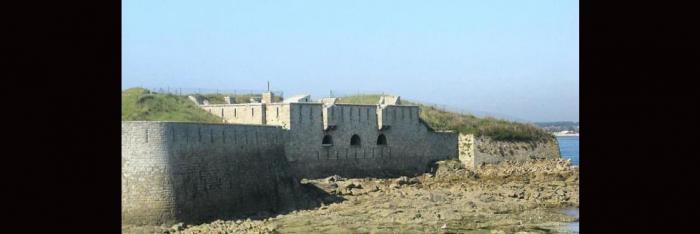
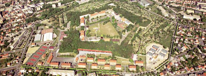
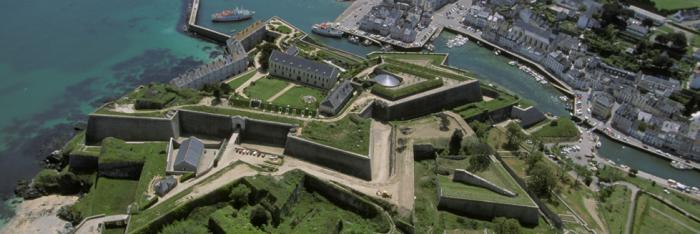
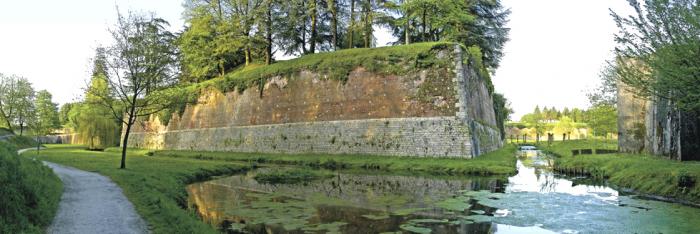
The well-preserved enclosure has the shape of an irregular octagon. It is defended by eight bastions and has been fully restored. There are two walking circuits open to the public:


- The ramparts: hiking card available from the Conseil Général du Nord.

- Discovery of the trees on the ramparts of Le Quesnoy: Circuit designed by the Parc Naturel Régional de L'Avesnois.


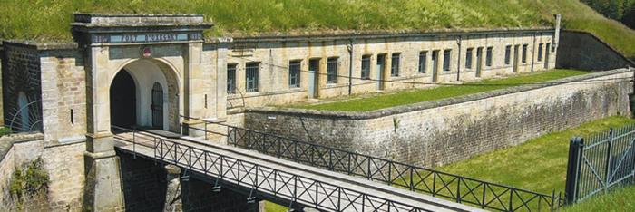
As you walk around the fortifications, stopping to read the educational panels, you can admire the eight bastions and seventeen outwork constructions in the ditches. Worthy of mention are the 18th century gunpowder store, the medieval tower of Count Baudouin, the Porte Fauroeulx, the Fauroeulx hornwork from the 18th century and five bastions: royal, imperial, green, Gard and Saint-Martin. Outside, the Pont-Rouge pool which was used to fill the ditches is now a watersport site.


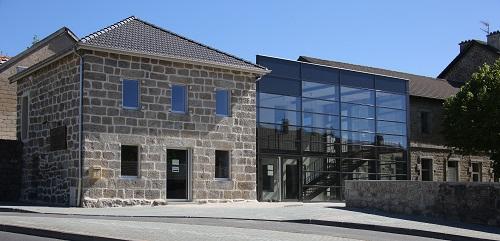
Every year during the Heritage Days, a military encampment of the revolutionary armies, animates the fortified site for two days, with over 400 participants. An association called "Le Cercle Historique Quercitain" is researching the past of Le Quesnoy and its two cantons. It has premises in the Cernay centre, or the Château Marguerite de Bourgogne, where it welcomes groups to look around two exhibition rooms covering the history of the fortification. Since 1987, the fortified cities have had a regional day on the last Sunday of April, and some citadels, which are now military barracks, regularly open their doors to the public. Lastly, the route of fortified cities, launched in 1993, gives the public the chance to discover these cities, armed with a map and explanation cards available from the Association des villes fortifiées and in the tourist offices of Ambleteuse, Arras, Avesnes-sur-Helpe, Bergues, Boulogne-sur-Mer, Calais, Cambrai, Condé-sur-Escaut, Gravelines, Le Quesnoy, Lille, Maubeuge, Montreuil-sur-Mer and Saint-Omer.


This war memorial commemorates the victory of the New Zealand Rifle Brigade, which liberated Le Quesnoy on 4 November 1918 from the German garrison which had occupied the town for four years. The New Zealanders climbed the fortifications with ladders, just like in the Middle Ages.

In 1999, Le Quesnoy opened the "Centre de documentation relatif à la libération de la ville en 1918", a documentation centre concerning the town's liberation in 1918. Le Quesnoy has become the main site for World War 1 commemorations for New Zealand in France, with a ceremony organised by the ambassador of New Zealand in Paris, the local authorities and the Commonwealth War Graves Commission. During these ceremonies, a parade including the mayor and local authorities, war veterans, visitors and people from the region crosses the town up to the ramparts and the New Zealand war memorial of 1923 to lay a wreath. The procession then moves towards the French war memorial to lay another wreath. The ceremony ends at the town hall, where a tribal sculpture "teko teko maori" perpetuates the memory.


New Zealand is still officially represented at Le Quesnoy during commemorations for the Armistice, on 11 November. New Zealand parliament officials and other groups, such as the New Zealand rugby team, have been to this town several times. Le Quesnoy and Cambridge in New Zealand were twinned in 1999.


Association des villes fortifiées

Hôtel de Ville Rue Maréchal Joffre 59530 Le Quesnoy

Tel.: +33 3.27.47.55.54
 

Le Quesnoy Tourist Information Office

Tel.: +33 3.27.20.54.70


e-mail : OTSI.le.quesnoy@wanadoo.fr


Quizz : Forts and citadels

> Return to results

Practical information

Address

Rue Maréchal Joffre 59530
Le Quesnoy
03 27 47 55 54

Weekly opening hours

Accessible toute l'année

Saint-Malo

Saint-Malo. Source : ECPAD

The fortified city of Saint-Malo...

The fortifications of Saint-Malo encircle the enclosed part of the town for almost 2 km. From Saint Vincent Gate (which dates back to 1709) to the Saint Thomas Gate, each curtain is steeped in history and has a multitude of panoramic views over the Bay of Saint-Malo.

The fortifications of Saint-Malo have a particularly rich history. 1) The city only began to develop in the 12th century, with the fortifications dating back to medieval times. Saint-Malo was highly sought-after: under the reign of Duchess Anne, this town surrounded by ramparts was already a fortress. At the time of Jacques Cartier, the fortifications of Saint-Malo would be developed even more. The 17th and 18th centuries mark a period of great prosperity for the city, thanks to the healthy growth of commerce, and the city became even stronger. Vauban built new ramparts and many forts sprang up around the bay to defend the port. These fortifications would later help thwart the English landings of June and September 1758, at the time of the battle of Saint-Cast. 2) Saint-Malo is particularly badly hit in August 1944. Under orders from Hitler, Colonel Von Aulock transformed the glacis of Saint-Malo into a veritable fortress from 1942. For one week in August 1944, the city is caught in crossfire between German and American troops and is almost totally gutted by fire. 80% of the town is destroyed. Chateaubriand Square and the Magon de la Lande Hotel are the only districts that escape the flames. In fact, once the fire is finally extinguished, the only parts of the city still standing and almost completely intact are the 2km of ramparts.
This pirate city is the starting point of some of the most famous nautical competitions, such as the "Route du Rhum", and is renowned for its literary festivals, including "Etonnants Voyageurs" and "Quai des Bulles" and art festivals such as "Si Tous Les Ports du Monde". As well as hosting these important events, Saint-Malo is a town with a very special character where everyone can find the role that suits them best: spectator, actor, or just a person out for a stroll. Practical information Saint-Malo Tourism Office Esplanade Saint-Vincent, 35400 Saint-Malo Tel: +33 (0)8 25 16 02 00 Fax: +33 (0)2 99 56 67 00 E-mail: info@saint-malo-tourisme.com

> Return to results

Practical information

Address

35400
Saint-Malo
08 25 16 02 00

Weekly opening hours

Accès libre

Châteaudun

Place du 18 octobre - Châteaudun. Source : carte postale

This walk is dedicated to the events of the Franco-Prussian War that marked Châteaudun

Memory Trail in the town This walk is dedicated to the events of the Franco-Prussian War that marked Châteaudun.

Five illustrated markers relate the inhabitants' heroic defence against the Prussians on 18 October. The first three are in Place du 18 Octobre, the fourth on Rue Jean Moulin and the fifth next to the defence monument on the Mall.
On 3 October 1877 a decree entitled the town to add the Legion of Honour cross on its coat of arms in recognition of its bravery. In 1884 Place Royale was renamed Place du 18 Octobre in remembrance of that day. The events On 20 September groups of highly mobile Uhlans blockaded Paris before advancing in Beauce. From 26 September 1870 to 6 January 1871 the Prussian army relentlessly crossed the Eure-et-Loir department in every direction. Since early October Châteaudun had been under the command of General Ernest de Lipowski. On the 28th the besieged town's residents put up barricades in the streets. On 18 October just 1,200 snipers, sedentary national guardsmen and firemen defended Châteaudun. A military force of 12,000 Prussians under the command of General von Wittich, armed with 24 cannons and two howitzers, showed up in the east. Seven cannons fired at the railway station at around noon.
At around 6pm the Rue Galante (Rue de Civry) barricade, which was isolated and too far forward, gave way. The Prussian thrust could no longer be repelled. The snipers retreated to the town centre, despite the darkness. The Prussians tried to overrun the square. A terrible night battle ensued. The defenders pushed the enemy back in the Rues de Chartres (Rue Jean Moulin) and d'Orléans (Rue de la République) three times. They fought by torchlight and bodies literally covered the ground. The painter Philippoteaux immortalised the fighting (the original is in the Châteaudun mayor's office). Despite the last bursts of courage, the defenders had to give up the now-hopeless struggle.
Shells and incendiary rockets rained down on the town at the rate of 10 a minute all day, ripping open roofs and destroying houses. On the night of 18-19 October the Prussians set the town on fire, pillaging, raping and driving out the inhabitants. At the Hôtel du Grand Monarque, where 70 Prussians had just been served an excellent dinner, the owner threw herself at General von Wittich's feet, begging him to spare her business. But the Duke of Saxony set the curtains on fire and the building quickly burned to the ground. Atrocities lasted all night and the next day. A monument to the victims and defenders was erected in Champdé Cemetery in 1873. A national fund-raising drive was launched to build a better monument to Châteaudun's valiant resistance. It was inaugurated on the Mall on 18 October 1897.
Antonin Mercié sculpted the bronze statue of a woman with a wall crown on her head representing the town of Châteaudun. Seriously wounded, she collapses and leans on a sniper from Paris, who, with his rifle on his shoulder, is still holding out and using up his last cartridges.

> Return to results

Practical information

Address

place du 18 octobre 28200
Châteaudun

Weekly opening hours

Accès libre

The Rimplas fortification

Vue générale du gros-ouvrage de Rimplas. Secteur fortifié des Alpes-Maritimes de la ligne Maginot. Source : GNU Free Documentation License

Originally called the Madeleine fortification, this was the Maginot Line's earliest ouvrage, or defensive work; construction began in 1928.

Originally called the Madeleine fortification, this was the Maginot Line's earliest ouvrage, or defensive work; construction began in 1928. The French government decided to build it after Mussolini's many sabre-rattling statements on the Nice region's Italian origin.

The Alpes-Maritimes General Council later bought the site to turn it into a "place of remembrance". "Les Amis de l'Ouvrage Maginot de la Madeleine", an association formed in early 2008, has begun rehabilitating the inside and outside and opened the site to the public during the 2009 Open Heritage Weekend.
Rimplas does not illustrate the concepts implemented in the later fortifications: it is in a single block surrounded by escarp walls whose blocks all face one way. They are veritable armoured casemates with 20cm-thick steel reinforcing the concrete walls, which extend inside and wrap around the cannon; two armoured shutters close the embrasure. The construction ran into many problems. First, the soil's crumbly nature required the excavated areas to be covered in concrete in several places. Second, there was severe water infiltration; in July 1936 cracks were still observed in the concrete. The fort was officially handed over to the 74th Alpine Fortress Battalion (BAF) in August 1937, before the work was totally completed.
Mission The Rimplas ouvrage has views stretching from the Upper Tinée in the north to Saint-Dalmas and La Colmiane in the west; its searchlights could scan the Upper Tinée road and the road to Saint-Martin-Vésubie. The fort could fire frontally towards the border, which was less than 5km away and ran along the present-day D2565 before the 1947 rectification. The frontier, which ran along the road between Isola, where a casemate stood, and Valabres, at the mouth of Mollières Glen, encircled nearly three-fourths of the town of Saint-Martin-Vésubie.
Composition The Rimplas ouvrage consists of five blocks connected to underground tunnels and indoor and outdoor facilities: Mixed entrance: three machine gun embrasures, mixed door, aerial tram entrance; B1: two 81mm mortar embrasures, two embrasures for twin Reibel machine guns and one grenade-launcher cloche. The mortars could fire frontally northward, but not as far as the border; B2: one machine gun embrasure; B3: one machine gun cloche and one cloche for twin Reibel machine guns; B4: two 1933 model 75mm howitzer embrasures, one 1931 model 75mm howitzer embrasure, one machine gun cloche, one observation cloche; however, the howitzers could not reach Isola, where an SFAM outpost was located. The underground rooms contained all the usual logistical facilities for a fortification of this size, and even an operating room. The tunnels and rooms are on three levels. B5: two 1933 model 75mm howitzer embrasures, one 1931 model 75mm howitzer embrasure, one machine gun cloche and one observation cloche (this block is the same as the previous one, except for the machine gun cloche). The row of howitzers covered the border to Saint-Martin-Vésubie and beyond. An observation post, located outside on the west façade, consists of an underground casemate closed by a concrete mask. The row of howitzers covered the entire border to the northeast. An emergency way out is atop the west cliff near the present telephone tower. A masonry casemate covered with a reinforced concrete slab stands before the curve in the road leading to the esplanade. The security barracks in the village of Rimplas.
The single-cable aerial tram built by Brien-Anzun, whose lower shaft can still be seen beside the Upper Tinée road, was 878m long, rose a total of 602m and could transport 52 tonnes of munitions or supplies every day in 21 cars. It was powered by two internal combustion motors. In 1939 the Rimplas fortification had a big garrison of 334 soldiers and eight officers from the 84th Alpine Fortress Battalion (BAF) and 167th Position Artillery Regiment (RAP).
The fighting In June 1940 the border zone between Saint-Etienne-de-Tinée and Valdeblore was held by four Ski Scout Sections (SES) belonging to the 84th BAF and 55th RIA: I/55 at Mont Raja, II/55 at Collet de la Sagne, III/55 at Bifarquet and that of the 84th BAF at Cabanes de Lenton. They faced off against the Val Elero battalion of the 1st Alpini. Italy declared war on France on 10 June but the actual offensive did not start until the 20th, when units of the Livorno division crossed the border near Isola and came up the Tinée halfway to Saint-Etienne-de-Tinée, trying to reach the road from Roya to Péone by way of Tolondet, certainly knowing the guns of Rimplas could not cover the area. Nevertheless, they were stopped at Pont-Rouge, before Douans. No source reports fighting in the sector in the following days and up to the armistice. Fort Rimplas nevertheless shelled the border to try and keep the Italian troops from coming across. The enemy did not breach the frontier in this sector and never threatened the work.
Present condition After the 24 June 1940 armistice the Italians disarmed and dismantled the fortification, taking away the 75mm guns. Fort de Rimplas was partially rearmed in 1947 and maintained by the army's corps of engineers until being decommissioned in 1972, when it was sold to the town of Rimplas. The municipality rented it to a company that grew mushrooms; the resulting humidity caused further damage. Much of the fort's interior was sold as scrap. Very little is left inside, but the camouflage painting and false embrasures are still quite visible on the escarp walls.
Rimplas ouvrage Les Amis de l'Ouvrage Maginot de la Madeleine 3 Promenade Saint Roch - Hôtel de ville 06420 Rimplas Tel: 06 80 59 09 94 Fax: 04 93 02 89 19 E-mail: contact@la-madeleine.asso.fr Contact the association for tours Contact Milano Nicolas, Président: nicolas@la-madeleine.asso.fr Icardo Laurent, guide: laurent@la-madeleine.asso.fr

> Return to results

Practical information

Address

6420
Rimplas
06 80 59 09 94

Prices

Adultes: 3 € Enfants (+ de 6 ans): 2 € Gratuit : Enfants (- de 6 ans)

Weekly opening hours

du deuxième weekend de mai au troisième weekend de septembre, le samedi de 14h à 18h

Fermetures annuelles

D'octobre à Avril