Newsletter

Ajaccio Citadel

Ajaccio Citadel. Source : http://domy66000.canalblog.com

The citadel, which was built in 1492, was a base of operations complementary to Calvi and Bonifacio.


Ajaccio, which is set at the top of a gulf, has been inhabited since Ancient times. From the 12th century onwards, the Genoese, wishing to establish a base of operations to support Calvi and Bonifacio in defending them against the threat from the Barbary Coast, built a fortification on the site, named Castel Lombardo.


Unfit for habitation, the position was abandoned three centuries later in 1492-1493 in favour of Capo di Bollo at Leccia Point. Cristoforo de Gandino, Francesco Sforza's military architect, was appointed by the Company of St. George to carry out the work for this site and at Calvi. Genoese and Ligurian families including the Bonapartes then set up a populating colony.


At that time, the town was structured around a fan formation of three roads: the Strada del Domo, the Strada San Carlo and the Strada Dritta, to plans drawn by the architect Pietro da Mortara. The citadel, which was built at the same time, was initially made up of a keep or citadel (castello) and a low curtain wall. In 1502-1503, the defensive features were enhanced with a ditch dug in rock around the citadel, accessible via a drawbridge, and strong walls around the settlement.


The town, which fell under French control between 1553 and 1559 was modified and extended, taking on its current hexagonal shape, the corners of which were reinforced with bastions. The Cateau-Cambrésis treaty returned the town to the Republic of Genoa, which commissioned the engineer Jacopo Frattini to fortify the seafront. He had a bastion built there, separated from the town by a ditch. During the 18th century, Corsica struggled in vain to escape foreign domination; in 1729, 1739 and 1763 the islanders attempted to take control of Ajaccio but it was placed directly under French control when the Genoese sold the island to France in 1768.


Napoleon Bonaparte was born in this town, and biographers tell that the ramparts and the citadel fuelled his games and dreams before featuring in his military and political career.

Used as a prison during the Second World War, Ajaccio Citadel was to be the last destination of the heroic Resistance fighter Fred Scamaroni. Scamaroni, who created the Gaullist Corsican Action R2 network in 1941, was mandated by General de Gaulle in January 1943 to try to bring unity to the Resistance movement. Betrayed by his radio operator, he was arrested by the OVRA (Italian counter-espionage) during the night of 18-19 March 1943. He chose to cut his throat with a piece of wire, leaving a last message written in his own blood: "Long live France and long live de Gaulle".


The citadel belonged to the Ministry of Defence until it was passed over to the city of Ajaccio in 2005.


Ajaccio city tourist office

3, Bd du Roi Jérôme BP 21 20000 Ajaccio

Tel: +33 (0)4 95 51 53 03

Fax: +33 (0)4 95 51 53 01

> Return to results

Practical information

Address

Boulevard Danielle Casanova 20000
Ajaccio
Tél. : +33 (0)4 95 51 53 03Fax : +33 (0)4 95 51 53 01

Weekly opening hours

Accessibilité toute l'année

The Eiffel Tower

View of the Eiffel Tower. Source : HjalmarGerbig

The Eiffel Tower, the symbol of Paris and a military tool

The project for a tower 300 metres tall was instigated during preparations for the World Exhibition of 1889. The two principal engineers from the Eiffel company, Emile Nouguier and Maurice Koechlin, had the idea in June 1884 for a very tall tower, designed like a large pylon consisting of four lattice-work girders, outspread at the base and coming together at the top, linked together by metal girders placed at regular intervals. On the 18th September 1884 Gustave Eiffel was granted a licence "new authorisation for the construction of metal structures and pylons over 300 metres tall". The curvature of the uprights was determined mathematically in order to provide the best possible resistance to the effects of wind. Erection of the supports began on the 1st July 1887, to be completed twenty-one months later. All the components were prepared at the factory in Levallois-Perret in the Paris suburbs, the head office of the Eiffel company: between 150 and 300 workers were involved in its assembly. The Tower was erected with the aid of wooden scaffolds and small steam driven cranes attached to the Tower itself. The assembly of the first level was carried out using twelve temporary wooden scaffolds 30 metres high and then four large 45 metre scaffolds. Started in January 1887, the project was completed on 31st March 1889. Gustave Eiffel was decorated with the Legion of Honour on the platform at the top.

A showcase for French industrial dynamism at the 1889 World Exhibition, the Tower would see more than two million visitors pass by during the event. Gustave Eiffel saved his work from demolition by promoting research into radio transmissions and suggesting that his tower could be used as an enormous radio mast. After the first radio signals were broadcast by Eugène Ducretet towards the Panthéon in 1898, Eiffel approached the military authorities in 1901 with a view to making the Tower into a long-distance radio antenna. In 1903 a radio connection was made with the military bases around Paris, and then a year later with the East of France. A permanent radio station was installed in the Tower in 1906, thus ensuring its continuing survival. During the Great War, the Tower provided many services by listening to enemy transmissions, which gave it the nickname "the big ear". It is thanks to the Tower that Joffre would be informed of the advance of von Klück's troops and decide to requisition all the taxis in Paris to send soldiers to the Marne. It was responsible, amongst other things, for the arrest of Mata Hari because, once again, the Eiffel Tower had kept an ear out and deciphered the spy's messages. In 1921 the first public radio broadcast in Europe would be transmitted from its aerials. The first television trials from the Tower date from 1925 and the first regular broadcasts from 1935. In May 1940, before the German troops arrived, a handful of patriots carried out acts of sabotage on the Tower, successfully enough to ensure that the lift did not work when Hitler came. A strategic place for commanding the city of Paris, the Tower was closed to the public between 1940 and 1945; it would not reopen until June 1946. Radio broadcasts were made from the centre at Allouis under the control of the occupying authorities, who took control of Radio-Paris. The top of the tower has been modified over the course of the years in order to accommodate ever more antennae. Today it accommodates several dozen antennae of all kinds, including a television mast that is 324 metres tall.

> Return to results

Practical information

Address

pont d'Iena 75007
Paris

Prices

Billet d'entrée ascenseur (jusqu'au 2ème étage) : Adultes 8,50€, jeunes (12 à 24 ans) 7,00€ enfants (4 à 11 ans), handicapés 4,00€ Billet d'entrée ascenseur avec sommet Adultes : 14,00€, jeunes (12 à 24 ans) 12,50€, enfants (4 à 11 ans), handicapés 9,50€ Billet d'entrée escalier (jusqu'au 2ème étage) Adultes 5,00€, jeunes (12 à 24 ans) 3,50€, enfants (4 à 11 ans), handicapés 3,00€

Weekly opening hours

Ouverture tous les jours de l'année de 9h00 à minuit du 15 juin au 1er septembre et de 9h30 à 23h le reste de l’année Week-end de Pâques et vacances de printemps : ouverture prolongée jusqu'à minuit.

Citadel of Blaye

Citadelle de Blaye. Source : http://citadelleblaye.free.fr/

The citadel of Blaye, keystone of the defence device of La Gironde.

The Citadel of Blaye is one of the finest examples of 17th century military architecture. Started in 1652 by Pagan, it was extended, strengthened and completed by Vauban between 1685 and 1689. Designed to protect the port of Bordeaux, this complex seals off the Gironde at Blaye. On the right bank, it consists of a citadel comprising three successive fronts with orilloned bastions, a demi-lune and covered walkway, all of which are typical of Vauban's second system. On the Gironde side, a wall and batteries overlook a cliff that overhangs the river at a height of 45 metres. However, the range of artillery at the time was not capable of totally preventing ships from passing. Vauban therefore designed two other forts which allowed artillery cross-fire and the control of the Gironde.

On the left bank, the engineer Ferry built Fort Médoc, which was trapezoid in shape and had a very fine entrance gate. In the middle of the river, on a sand bank, he built a solid, low, round tower, Fort Paté, crowned with a parapet with embrasures and a gun terrace. The unstable nature of the ground made it necessary to set the tower on a double grill of wood, submerged for a year in the wet ground. Despite subsidence of 2 metres in 1707, the fort, which was consolidated in the 18th century, has remained intact.
The Citadel is still partly inhabited. Access is either on foot via the Porte Dauphine, or by car via the Porte Royale. Inside, there is the Museum of History and Art of the Blaye area. There is also the château des Rudel, a medieval triangular château where the troubadour Geoffroy Rudel, the lover of the "distant Princess" Melisande of Tripoli, was born. On the platform of the Tour des Rondes, an observatory offers a view across the town and over the Gironde estuary. From the Aiguillette Tower, you can also see the Gironde and all the little islands in it. Also worth seeing are the Place d'Armes where there is the Minimes Convent and the Pavillon de la Place, in which the Duchess of Berry was detained. A real little town within a town, the Citadel is on the list of Historic Monuments and today plays host to more than 200,000 visitors a year.
Tourist Information Office of the canton of Blaye Les allées marines 33390 Blaye Telephone: +33 (0) 5 57 42 12 09 fax: + 33 (0) 5 57 42 91 94 Mail: info@tourisme-blaye.com Opening and closing times The citadel is open every day all year round, with groups by appointment. Charges : Free entry

> Return to results

Practical information

Address

Place de la citadelle 33390
Blaye
05 57 42 12 09

Weekly opening hours

Accès libre

The Fort du Questel

Vue du fort détaché du Questel : front de gorge, porte d'entrée monumentale à pont-levis. (c) Inventaire général, ADAGP, 2006. Source : http://patrimoine.region-bretagne.fr

This fort watches over the junction of the valleys of le Moulin du Buis where the enemy could set up camp in order to bombard Brest.

Richelieu, the founder of the Port du Ponant, launched the first work to fortify the town, which was then continued by Vauban under Louis XIV. It was during the reign of Louis XVI, during the American War of Independence (1775-1783), that the king, fearing that the English would land in Brittany, decided to construct forts and redoubts.

Constructed in various ways depending on the geography of the area to be defended, they all however possessed the means to cross their fire and respond to the intermediate batteries built on the first sign of war. These fortifications, evidence of the history of Brest and the surrounding area, were in their time considered to be state of the art French fortifications on the eve of the revolution. The Fort du Questel is in reality a "redoubt", in other words, a fortified, square-shaped construction, whose entrance or gorge is located on the least exposed side. This enormous quadrilateral with 100 metre long sides is situated between the Fort du Kéranroux (1.5 km t the right) and the Fort de Penfeld (1 km to the left).
Le Fort du Questel watches over the junction of the valleys of le Moulin du Buis, where the enemy could set up camp in order to bombard Brest. Surrounded by deep moats and accessible by a drawbridge, it consists of a stone wall (escarpe), with a walkway around the top for use by the musketeers. This walkway is itself surmounted by a rampart made of earth, which is set back and designed to support the artillery (26 canons in total, with a range of up to 4.5 km). The garrison of around 200 men there had access to various galleries, including two large underground ones linking the central courtyard with the walkways. We should also note the presence of rest areas which, during Vauban's time, was still a privilege ...
Constructed on a 6 hectare site Fort du Questel overlooks the Valley of the Allégoet, a tributary stream of the river Penfeld. Today, this site is one of a series of redeveloped natural areas leading up to the banks of the Penfeld along a circuit that passes by the foot of the Cavale Blanche hospital. On its premises, the fortress provides scenic walks through its well-sheltered ditches, basements, staircases, scarp and counterscarps, esplanade and its nearby cool undergrowth. The Fort du Questel has also become a popular place for hosting many activities.

> Return to results

Practical information

Address

Chemin du Buis 29200
Brest

Weekly opening hours

Accès libre

Mont Canisy batteries

Visite gratuite assurée par les guides de l'association les Amis du Mont Canisy. Photo Michel Dehaye

The protected natural site of Mont Canisy overlooks the sea from a height of 110 metres.


Located at Bénerville-sur-Mer (Calvados), the protected natural site of Mont Canisy overlooks the sea from a height of 110 metres.


For centuries, the strategic position to the south of the Seine Bay occupied by this site has led it to be used successively as a seigniorial fief which was broken up in 1793, an anti-submarine defence post in 1917-1918, a coastal battery between 1935 and 1940 and then the largest artillery base of operations for the Atlantic Wall. In recent history, it has twice been used as a coastal artillery position: between 1935 and 1940 when the French Navy installed two batteries on the site to contribute to the defence of the estuary and Le Havre port, and between 1942 and 1944 when it became an important part of the Atlantic Wall defences, designed to repel any allied landing attempt.

Various installations from these two periods can still be seen (blockhouses, gun emplacements, fortified ouvrages linked by a 260-metre-long passageway housing an underground garrison, etc.).


Mont Canisy battery

Tel: +33 (0)2 31 87 91 14


Opening hours on Saturdays: 2.30pm to 5.30pm


Mont Canisy batteries website

> Return to results

Practical information

Address

Rue du Canisy 14910
Bénerville-sur-mer
02 31 87 91 14

Weekly opening hours

Accès libre

Longues-sur-Mer Battery

Bunker du Mur de l'Atlantique à Longues-sur-Mer. Source : GNU Free Documentation License

Part of the German Atlantic Wall defences 8 km north of Bayeux.

Part of the German Atlantic Wall defences, the Longues-sur-Mer battery is located 8 km north of Bayeux, in the Calvados département. Located to the west of Arromanches-les-Bains in Normandy, Longues-sur-Mer overlooks the ocean from the top of a 65-metre high cliff, making it an ideal position for the Germans to install a battery of four 150 mm cannon. It is one of the few remains of the Atlantic Wall still intact.

Starting at 0530 on 6th June 1944, several cruisers and a battleship bombarded the position. But when the landing fleet arrived offshore, the battery opened fire itself. HMS Ajax retreated one kilometre offshore. The German cannons ceased fire briefly then began again; the last gun continued firing until 1700 hours. The Longues-sur-Mer battery surrendered to the British the following day along with the184 men of the garrison. Four 150mm cannons with a range of 19.5 kilometres were mounted in this battery. A firing post, barely finished by 6th June 1944, was installed alongside the cliff.
Longues-sur-Mer Battery 14400 Longues-sur-Mer Tel.: +33 (0) 231 06 06 45 Fax: +33 (0) 231 06 01 66 Access from the D514 Open all year round Guided tours from Easter to September

> Return to results

Practical information

Address

14400
Longues-sur-Mer
02 31 06 06 45

Prices

Plein tarif: 3 €

Weekly opening hours

De 10h à 18h

Musée de la Résistance à Châteaubriant

Vue du site de la Sablière. Source : MINDEF/SGA/DMPA - JP Le Padellec

La Sablière fut le témoin d’un évènement de la Seconde Guerre mondiale. Le 22 octobre 1941, 27 otages furent fusillés par les Allemands en représailles de la mort du Feldkommandant de Nantes (Loire-Inférieure) Karl Hotz, tué deux jours plus tôt par de jeunes résistants français. Suite à cette date, La Sablière se fait appeler la « Carrière des fusillés » et des rassemblements rendant hommage aux fusillés de Châteaubriant s’organisent.


Consulter l'offre pédagogique du musée >>>  Châteaubriant


Le 30 septembre 1945, « L’Amicale Des Anciens Internés Politiques de Châteaubriant-Voves » est créée. Dès lors, cette Association a pour but de maintenir le souvenir de ces hommes, objectif intégré dans la démarche du tourisme de mémoire.

Cette ambition passe par l’entretien du mémorial national érigé à Châteaubriant et par l’aménagement de la Carrière des fusillés. Le site fut classé en 1993.

Le monument inauguré le 22 octobre 1950 fut réalisé par Antoine ROHAL, sculpteur.
Depuis 1951, les alvéoles devant le monument contiennent un peu de terre des hauts lieux de la Résistance. Tout autour de la carriére sont installées en 1986 les stéles portant photographie et les indications personnelles de chaque fusillé.

Elle passe également par l’organisation de commémorations et de conférences. Actuellement, le titre est « Amicale de Châteaubriant-Voves-Rouillé-Aincourt ».

Pour transmettre cette histoire au public, le Musée de la Résistance à Châteaubriant,implanté dans la ferme qui jouxtait la carrière où ont été fusillés 27 hommes dont Guy Môquet, est inauguré en 2001 par l’Amicale. En 2007, l’Amicale délègue la gestion et l’animation du Musée à l’« Association des Amis du Musée de la Résistance de Châteaubriant ». Des expositions permettent de mieux comprendre la vie des internés et la Résistance dans le pays de Châteaubriant. Chaque année, une exposition en lien avec le thème du Concours National de la résistance et de la Déportation.

L’Office de Tourisme Intercommunal du Castelbriantais propose des visites guidées payantes de la Carrière et du Musée. Le Musée peut également être visité de manière libre et gratuite. Des documents sont mis à la disposition du public.


Sources : ©Musée de la Résistance à Châteaubriant
> Return to results

Practical information

Address

La Sablière, Carrière des Fusillés 44110
Châteaubriant
02 40 28 60 36 (ou office de tourisme : 02 40 28 20 90)

Prices

Gratuité (sauf office de tourisme)

Weekly opening hours

Mercredi et samedi de 14H à 17H et sur rendez‐vous pour les visites de groupes en téléphonant

Fermetures annuelles

Le Musée est fermé au public du 23 décembre 2015 au mardi 12 janvier 2016 inclus, la réouverture s’effectue le mercredi 13 janvier 2016 à 14h.Office de tourisme de référence - 29 Place Charles de Gaulle ‐ BP 203 ‐ 44146 CHATEAUBRIANT Cedex - Tel. : 02 40 28 20 90

Bois de Boulogne Waterfall Monument

Bois de Boulogne Waterfall Monument. Source : GNU Free Documentation License

On 16 August 1944, the Germans massacred 35 young members of the Francs Tireurs Partisans, who fought for freedom and hope.

On 16 August 1944, 35 young people between 18 and 22 years old were shot behind the Reservoir pond after having fallen into a trap that led to their arrest. They belonged to three Resistance organisations and included 20 francs-tireurs and partisans from the town of Chelles, three members of the Civil and Military Youth Organisation and 12 Young Christian Fighters who wanted to participate in the liberation of Paris (25-26 August). They accepted a mission from a so-called intelligence service agent, who asked them to transport weapons, and showed up at the meeting place, Place des Ternes, without arms. Almost as soon as they did, they were encircled by the Gestapo and brought to its headquarters, where they were interrogated until 10pm before being taken to the waterfall and shot. Every year, this tragic event is commemorated on the spot where it occurred and where the old oak trees "still have the bullets that killed these teenage boys lodged in their hearts".

The Bois de Boulogne was bombed several times during the Second World War, but the most tragic incident took place on 4 April 1943, when six of the 38 bombs that fell on the 16th arrondissement hit the Longchamp racetrack on opening day, killing many civilians. In memory of that tragic day, coniferous trees were planted in the holes caused by the bombs in the forest, but a storm uprooted many of them in December 1999.
Bois de Boulogne Waterfall Bois de Boulogne Carrefour de Longchamp 75016 Paris

> Return to results

Practical information

Address

Carrefour de Longchamp 75016
Paris

Weekly opening hours

Accessible toute l'année

Casemate of Pont Saint Louis

Petit bunker près de l'ancienne douane supérieur. Photo : Tangopaso

The casemate is to be found in a small square opposite the French customs building ...

The casemate of Pont Saint Louis is to be found in a small square opposite the French customs building to the left of the Number 5 trunk road, barely 7 metres from the border. It consists of the casemate itself, an anti-tank barrier and a permanent mine device (dispositif de mines permanent or DMP) located 20 metres behind at the Garavan crossroads, opposite the current police station. It also comprises an anti-tank barrier completed by a minefield, i.e. two rows of 6 holes in which Ollivier piquets (105 mm shells mounted on steel stakes) were set. The anti-tank barrier was strengthened with torque rods and the obstacle was completed with barbed wire. Originally, a trench led towards the double doors on which there was a support for an FM 24/29 used for the close defence of the access trench. This position was used for launching signalling grenades or rockets in order to request artillery fire (green rocket) or possible withdrawal of the company (red rocket). Construction of the fortification The fortification was built by a civil company at a cost of 0.34 million old Francs. For comparison purposes, the Cap Martin fortification cost 17 million Francs. The pilot study dates back to the 1st October 1930, but a project from the 14th March 1940 allowed the acquisition of extra premises. The structural work was finished in August 1932 following several incidents, in particular problems with the housing for the 37 mm canon. In 1934, the fortification was permanently commissioned. The casemate was finally finished, despite the doubts raised by General Besson when he inspected the fortification in April 1938: "this blockhouse won't last 5 minutes... ".

Description of the fortification We enter through a narrow corridor about twelve metres long, 0.80 metres wide and 1.70 metres high, which leads to the firing chamber. Opposite the entrance there is a small 2 metre square room, which contains a ventilation system, a filtering box and a space that is also used for ventilation. Outside, there is the OTCF radio station aerial and telephone cable linking the building with Cap Martin. The firing chamber contains a slot for an FM 24/29 and space to house either the 37 mm 1934 model anti-tank canon or Reibel machine guns. Taking into account the proximity to the border and the reduced firing range (6 metres wide and 10 metres long) the canon has always remained in the space and the pair of machine guns have never been used. A grenade launcher chute is located to the right of the anti-tank housing.
The crew of the casemate was taken from the 96th Alpine Fortress Battalion and comprised Sergeant Bourgoin, Corporal Lucien Robert, some alpine soldiers, Gaston Chazarin, Marcel Guzzi, Nicolas Petrio, André Garon and Paul Lieutaud and was commanded from 17th June 1940 by sub-lieutenant Charles Gros. The casemate and its crew were cited on the Order of the Army by General René Olry.
The casemate of Pont Saint Louis Esplanade Jojo Arnaldi 06500 Menton Tel.: +33 (0) 6 64 26 34 61 or +33 (0) 6 69 48 69 57 Access : Bus lines 3 and 8 from Menton railway station Open to the public all year round by appointment. From June to September: on Saturdays by appointment and on Sundays from 9 am to 12 pm and from 2 pm to 6 pm Prices Group (more than 10 people): 1€ 50 Adults: 1€00 Children (under 10 years old): 0€50 Free (on production of card) for Police, military police, customs officers, ex-servicemen and military personnel. Document in Pdf format - 5 Mo June 1940 - the glorious defence of the Pont Saint-Louis - Source: www.maginot.org

> Return to results

Practical information

Address

Esplanade Jojo Arnaldi 6500
Menton
06 64 26 34 61 06 69 48 69 57

Prices

Groupe (+ de 10 personne): 1,50 € Adultes: 1 € Enfants (- de 10 ans): 0,50 € Gratuit : Policiers, gendarmes, douaniers, anciens combattants, militaires

Weekly opening hours

Ouvert toute l'année sur RDV. De juin à Septembre, ouvert le samedi sur RDV et le dimanche de 9h à 12h et de 14h à 18h

The fortified town of Perpignan

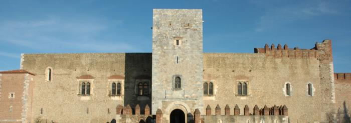
Palace of the Kings of Majorca Source: ©Renalias Josep - License Creative Commons - Public domain

It was the scene of invasions, battles during the war of the Spanish succession, Napoleonic wars and fights against Nazism.

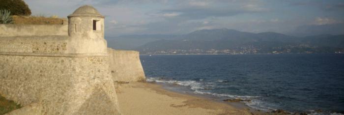
Perpignan is a border town in the Pyrénées-Orientales département of France and a place of passage.


Situated on Via Domitia – ancestor of today's No. 9 motorway –, it was the scene of invasions, rivalry between France and Catalonia, battles during the war of Spanish succession and then the Napoleonic wars, and fights against Nazism.


Owned by the Kingdom of Majorca, James II, known as "the Conqueror", settled in Perpignan in 1276 and raised the town to the status of a capital. He had his palace built there, which is the oldest royal residence in France. His son, James III, was driven out by Peter IV of Aragon. The Palace of the Kings of Majorca then became a temporary residence for the kings of Aragon. Pope Benedict XIII stayed there in 1408.


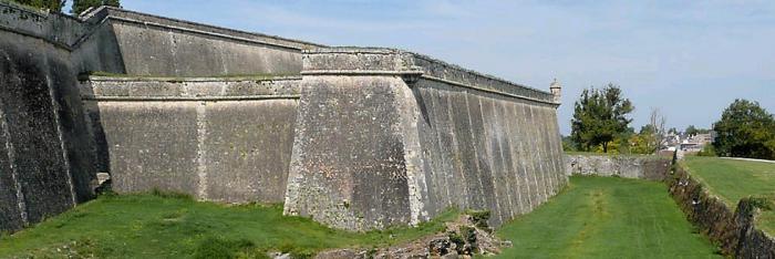
The building is a fortified palace in the Gothic style, organised around three courtyards. The entrance is protected by a moat and a crenelated barbican. Its architects were Ramon Pau and Pons Descoll. As a result of the 16th-century wars between France and Spain, Perpignan changed from being a border town to being a citadel, the border stronghold: in 1540, Charles Quint added a remote line of fortification to the citadel; Philip II of Spain had the red brick ramparts built in 1587 in a hexagonal shape.

After becoming part of the Kingdom of France by the Treaty of the Pyrenees in 1659, Perpignan became a proper garrison town.

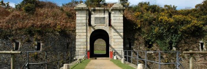
Vauban reinforced the defence system by adding fortified structures inside and outside the wall built by Philip II: six half-moons were added. He suggested building living quarters inside the citadel and, to solve the issue of expulsions caused by extending the place of arms, he suggested building a "new town" to the north, which he included in his plan of the exterior wall. The military architect incorporated it into a clever defence mechanism on the Catalonia border. He closed the lines of communication via the Collioure - Port-Vendres - Fort de Bellegarde fortifications.
 

To prevent an invasion via secondary cols (in the Tech and Cerdagne valleys), he designed Prats-de-Mollo, Fort des Bains, Mont-Louis and Villefranche-de-Conflent. The rear of the system was reinforced by Perpignan.
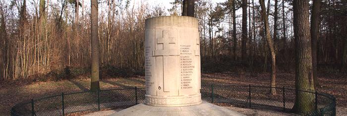
The Revolution and the Empire developed the military character of the city and even claimed a number of public monuments and religious rights-of-way for the troop.


Perpignan Tourist Office

Palais des Congrès - Place Armand Lanoux BP 215 66002 Perpignan Cedex

Tel: +33 (0)4.68.66.30.30

Fax: +33 (0)4.68.66.30.26

E-mail: contact-office@perpignan.fr


Palace of the Kings of Majorca

4 rue des Archers 66000 Perpignan

Tel.: +33 (0)4 68 34 48 29


Summer opening times: closes at 6pm. Winter opening times: 9am to 5pm


Closed on 01/01, 05/01, 01/11 and 25/12


Quiz: Forts and citadels

> Return to results

Practical information

Address

Place Jean Moulin 66000
Perpignan
Tel : 04.68.66.30.30Télécopie : 04.68.66.30.26 Palais des Rois de Majorque4 rue des Archers66000 PerpignanTél : 04 68 34 48 29

Weekly opening hours

Ouvert 7/7 toute l'année. Du 1er septembre au 31 mai : de 9h à 17h Du 1er juin au 30 septembre : de 10h à 18h

Fermetures annuelles

Fermé les 1er janvier, 1er mai, 1er novembre et 25 décembre.