Newsletter

Fort of Meroux

Ouvrage de Meroux. © Monuments historiques. Source : Ministère de la culture - base Mérimée

This intermediate fortification was built between 1908 and 1913 to reinforce the line of defence between Fort de Vézelois and Fort Fougerais.

The intermediate fortification of Meroux was built between 1908 and 1913 to reinforce the line of defence between Fort of Vézelois and the Fort of Fougerais.


Small in size and with a very simple design, it represents the final step in the evolution of French fortification before the First World War.


Built entirely of concrete, it has a trapezoid shape and is surrounded by a ditch defended by two counterscarp coffers.


Access was via the ditch and all of the fort's parts are interconnected by bulletproof underground passages.


There is a parapet for infantry on top.


It could accommodate over 400 men in its barracks.

Fort of Méroux

Rue de l'Ouvrage

90400 Meroux


Tourist Information Office

2 rue Clemenceau

90000 Belfort

Tel.: +33 (0)03 84 55 90 90

Fax : +33 (0)3 84 55 90 70

E-mail : tourisme90@ot-belfort.fr


Quizz : Forts et citadelles


> Return to results

Practical information

Address

Rue de l'Ouvrage 90400
Méroux
Tel.: 03 84 55 90 90Fax : 03 84 55 90 70

Weekly opening hours

Se renseigner pour l'accessibilité au site

Fort of Côte-d'Essert

Ouvrage de la Côte-d'Essert. Source : ©Thomas Bresson - License Creative Commons - Libre de droit

This fort, built from 1890 to 1891, named "Batterie Édouard Thiers" in 1895, covered Fort du Salbert and that of Mont Vaudois. 

This intermediate fortification, built into the rock, is substantially different to the other intermediate fortifications built at the same time.
 
 
Although this fort was essentially built to fight against infantry infiltrations, it was equipped, in addition to four small-calibre canons (90 mm), with four long-range artillery pieces (120 mm) to cover the Route de Lure.
A cross between an intermediate structure and a battery, its original architecture marks a transition between the fort of 1874 and the intermediate structure of 1914, like Meroux.
 
 
It is a trapezoid with ditches defended by counterscarp coffers. Access was via the ditch. The rooms, all underground, were designed for more than 250 men.
 
 
Concrete was not used much as there is rock on site, which is a better substitute.  The only parts in concrete are the counterscarp coffers, the casemates defending the entrance and the shelters on the upper part (in particular the shelters for the 90-mm cannons on the flanks).


Tourist Information Office
 
2 rue Clemenceau 90000 Belfort
 
Tel: +33 (0)3 84 55 90 90
 
Fax: +33 (0)3 84 55 90 70
 
E-mail: tourisme90@ot-belfort.fr


Quizz : Forts et citadelles


> Return to results

Practical information

Address

90850
Essert
Tel.: 03 84 55 90 90Fax : 03 84 55 90 70

Weekly opening hours

Se renseigner pour l'accessibilité au site

Fort de Vézelois

Fort de Vézelois. Source : ©Thomas Bresson- License Creative Commons - Libre de droit

Fort Vézelois is a fort in the Séré de Rivières system of fortifications designed and built after the Franco-Prussian War of 1870-1871.

Built at the same time and following the same plans as that for Bessoncourt, Fort Vézelois was erected to cover the forts of Bessoncourt and Bois d'Oye and provide defence mainly along the roads leading from Switzerland and the Mulhouse railway.


It had the capacity for under 600 men and some 30 cannons.


As with Bessoncourt, in 1888-1889 it received a concrete shell over one third of its central barracks.


The majority of its artillery was also distributed in the exterior batteries after 1887, but no major modernisation appeared until 1909: Caponiers replaced by counterscarp batteries, shelters and parapets installed for the infantry, construction of a Bourges casemate, a 75-mm turret and two machine gun turrets.


Some underground excavation was carried out during the First World War.

Tourist Information Office

2 rue Clemenceau

90000 Belfort

Tel.: 03 84 55 90 90

Fax : 03 84 55 90 70

E-mail : tourisme90@ot-belfort.fr


Quizz : Forts et citadelles


> Return to results

Practical information

Address

90400
Vézelois
Tel.: 03 84 55 90 90Fax : 03 84 55 90 70

Prices

4€ / personne ; pour un autocar 35 personnes maxi : 90€

Weekly opening hours

Se renseigner pour l'accessibilité au site

Fort Bessoncourt

Le fort de Bessoncourt ou fort Sénarmont. Source : ©chuchu90

This fort was built between 1883 and 1886 to defend the roads between Colmar and Basel and the Mulhouse railway and to cover the Roppe and Vézelois forts. 

It is a large fort made from limestone masonry with a pentagonal layout, designed to hold 650 men and some 30 artillery pieces. It is characteristic of the forts with a massif central and batterie basse (main structure and low battery) in which the long-range and short-range artillery are assembled on the rampart bordering the ditch while the infantry stand over the caponiers and on the roof of the central barracks. But shortly after it was completed, it was already outmoded and had to undergo modernisation.


It is one of the rare forts in the area to have been constantly maintained to keep abreast with technical progress: in 1888, a concrete shell was poured over one-third of the central barracks; the majority of its long-range artillery was distributed around the neighbouring batteries, the fort became a point d'appui for the infantry and underwent a complete refit (caponiers replaced by counterscarp batteries, shelters built for cannons on the flanks and concrete shelters over the ramparts, variety of fortifications). In 1908-1909, two 75-mm cannon towers and two machine gun towers were erected.

During the First World War, the fort was used as a hospital, but from 1917, fortification work resumed with the digging of deep underground rooms and galleries to provide communication with the exterior (entrances at the rear and machine gun outposts at the front).


The successive modernisations it received gave this fort a particular personality and makes it an excellent testament to the development of French fortifications between 1885 and 1918.


Tourist Information Office

2 rue Clemenceau 90000 Belfort

Tel: 03 84 55 90 90

Fax: 03 84 55 90 70

E-mail: tourisme90@ot-belfort.fr


La Caponnière


> Return to results

Practical information

Address

Rue du fort 90160
Bessoncourt
Tel.: 03 84 55 90 90Fax : 03 84 55 90 70

Prices

4€ / personne ; pour un autocar 35 personnes maxi : 90€

Weekly opening hours

Se renseigner pour l'accessibilité au site

Fort Mont-Vaudois

Le fort du Mont-Vaudois, pont-levis. Source : http://www.hericourt.com/

This fort, built from 1874 to 1877, was intended to control the Lizaine valley and Châlonvillars plain in Échenans, and protect the routes to Montbéliard.

Fort Mont-Vaudois is located in Héricourt in the Department of Haute-Saône. A linkage between the fortified camp of Belfort and the southern curtain wall, this fort, built between 1874 and 1877, was intended to control the Lizaine valley and Châlonvillars plain in Échenans, and protect the routes to Montbéliard. Several adjoining batteries built around the fort completed its function.

Designed to hold 650 men and some 50 artillery pieces, it is a large trapeze-shaped fort with a complex internal layout. A semi-circular massif central or central structure housing the barracks is preceded by a high crest for the long-range artillery which is itself preceded by a low crest for the infantry and light artillery.

Firing in the same direction, a group of four casemates for indirect fire was placed behind this central structure. Its rear faces a line of open-air outposts firing in the opposite direction. Two doors provide a route to the exterior.

In 1889, in response to the crisis of 1885, underground casemates were dug beneath the fort to serve as bulletproof barracks during war time. However, being far down on the list of priorities, the fort had to wait until 1913 until it received any major modernisation works. Two 155 turrets, three machine gun turrets and rampart shelters were planned.

However, when the war started, only the concreting of one section of the barracks, two observation points and some underground passages were completed. The modernisation was then abandoned and the fort was restored improvising with the resources at their disposal.


Tourist Information Office

2 rue Clemenceau 90000 Belfort

Tel: 03 84 55 90 90

Fax: 03 84 55 90 70


E-mail: tourisme90@ot-belfort.fr


Source text: Antoine Brolli

> Return to results

Practical information

Address

70400
Etobon
Tel.: 03 84 55 90 90Fax : 03 84 55 90 70

Prices

Visite: 3 €

Weekly opening hours

Ouverture sur réservation d'avril à novembre. Pour les individuels : visite le 1er mercredi de chaque mois à 14h. Pour les groupes : sur demande.

Fort Giromagny

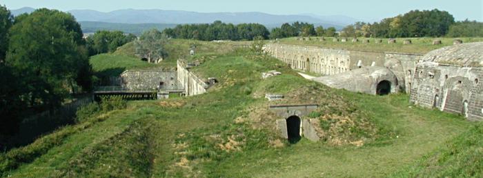
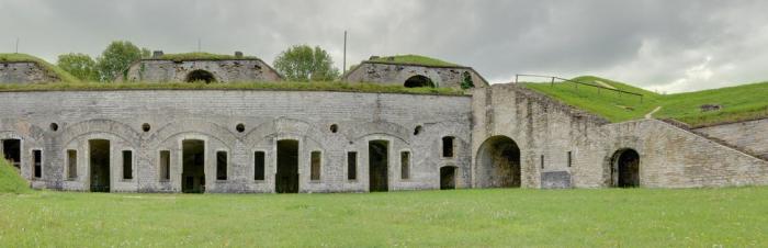
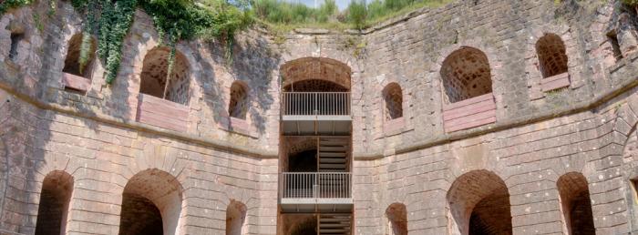
Cour intérieure du Fort de Giromagny. Source : ©Thomas Bresson- License Creative Commons - Libre de droit

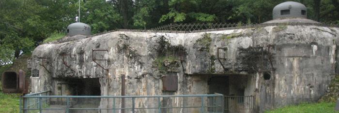
This fort stands at the southernmost point of the defensive curtain of Haute-Moselle that connects the fortified camps of Belfort and Épinal. 

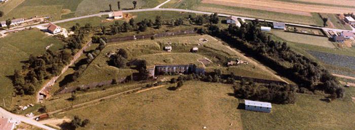
Fort Giromagny or Fort Dorsner stands at the southernmost point of the defensive curtain of Haute-Moselle that connected the fortified camps of Belfort and Épinal. Its role was to control the busy crossroads at Giromagny where an invasion route (from Ballon d'Alsace to Belfort) intersected with a road that bypassed the fortified camp of Belfort (the road from Masevaux to Champagney).


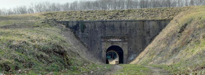
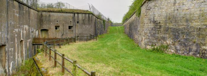
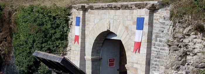
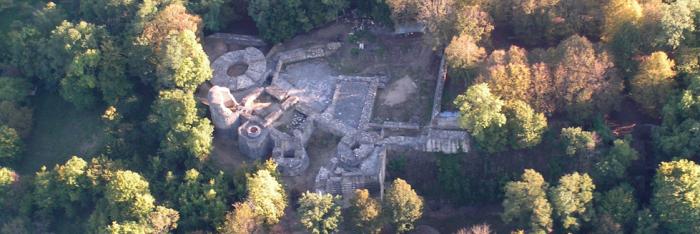
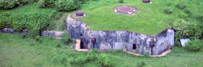
Built between 1875 and 1879, it had the honour of receiving the first two armoured turrets built in France (two revolving iron-clad towers each holding two 155-mm cannons) and the only ones in the Belfort fortifications before the 1900s. This trapezium-shaped fort with its compact architecture was equipped with shelter for nearly 650 men and a sizeable armament. A massif central was organised around a courtyard with attractive walls of rose sandstone. It housed the barracks and storehouses, six casemates for indirect fire and the two turrets. It was surrounded by a rampart equipped with open-air artillery outposts.

Fort Giromagny did receive some modernisation, albeit barely sufficient: Excavation of underground powder stores in 1888 then underground shelters in 1914, three observation posts (1913-1914) and some concreting to reinforce the vaults (1914-1916).


On 18 June 1940, the fort’s turrets fired missiles at the German troops before the garrison surrendered.


Le fort Dorsner et géré entièrement  par une association indépendante de tout autre organisme,

de bénévoles "l'Association du Fort Dorsner"(A.F.D.)


"l'Association du Fort Dorsner"(A.F.D.)

Tél. : 06 72 56 42 70        mail : fort.dorsner@laposte.net

Facebook : facebook.com/fort.dorsner


Ouverture au public du sommet, avec vue panoramique sur la trouée de Belfort

et ses alentours - Circuit visite libre à l’extérieur du fort.


ENTREE 3€/pers. (gratuit pour les moins de 12 ans accompagnés). 

Plus d’une heure de visite libre dans les souterrains et au milieu de l’architecture militaire.
 

OUVERTURE CHAQUE DIMANCHE 

et jours fériés du 3 juillet au 18 septembre (inclus) : de 14 à 18h (fermeture des entrées à 17h15)


Possibilité de visite guidée d’avril à octobre (Réservation obligatoire) 

pour les groupes de 30 pers. maxi (40 €/groupe).


Maison du Tourisme 2 rue Clemenceau 90000 Belfort

Tél. : 03 84 55 90 90 - Fax : 03 84 55 90 70

E-mail : tourisme90@ot-belfort.fr


Quizz : Forts et citadelles

 
> Return to results

Practical information

Address

Chemin du fort - 90200
Giromagny
06 72 56 42 70

Prices

3 € par personne pour les visites libres durant les dimanches après midi de juillet, août et septembre et 40,00 € pour les visites de groupe de maxi 30 personnes sur rendez-vous.

Weekly opening hours

OUVERTURE CHAQUE DIMANCHE et jours fériés du 3 juillet au 18 septembre (inclus) : de 14 à 18h (fermeture des entrées à 17h15) Possibilité de visite guidée d’avril à octobre (Réservation obligatoire) pour les groupes de 30 pers. maxi (40 €/groupe).

Fort des Basses-Perches

Le fort des Basses Perches. Source : © Dr Balliet J.M. - http://www.fortifications.fr

Fort des Basses Perches was built between 1874 and 1877 on the site of a terraced road built during the siege of Belfort in 1870.

On the southern edge of Belfort, Fort des Basses Perches was built between 1874 and 1877 from a dry masonry fort completed by Colonel Denfert-Rochereau in 1870.
 
The first known fortification on Perches hill (excavation work) dates back to 1815. It is a "cavalier"-type fort with open positions for long-range artillery positioned above the barracks, close-defence artillery and on-site infantry located on the lower ramparts crowning the ditch.
 
The particularity of Fort des Basses Perches is to have been built with counterscarp coffers instead of caponiers (covered passage) which were normally used at this time; the use of counterscarp coffers (less vulnerable as they are located on the other side of the ditch) did not become widespread until after 1885.
 
 
In times of war, a garrison of around 180 men was installed at Basses-Perches, 230 men at Hautes-Perches, with each fort armed with some 20 cannons. Neither of these two forts was modernised after construction.
Tourist Information Office
2 rue Clemenceau
90000 Belfort
 
Tel: +33 (0)3 84 55 90 90
 
Fax: +33 (0)3 84 55 90 70
 
E-mail: tourisme90@ot-belfort.fr
> Return to results

Practical information

Address

90400
Danjoutin
Tel.: 03 84 55 90 90Fax : 03 84 55 90 70

Prices

4€ / personne ; pour un autocar 35 personnes maxi : 90€

Weekly opening hours

Se renseigner pour l'accessibilité au site

Montrond Fortress

Saint-Amand-Montrond, vue aérienne de la forteresse. Source : forteresse-montrond.fr

The fortress, located on the hill at Montrond, provides a unique panoramic view of the development of military architecture from the 13th to the 17th century

The fortress, located on the hill at Montrond, at the confluence of the Cher and Marmande valleys, provides a unique panoramic view of the development of military architecture from the 13th to the 17th century. The restoration of the fortress, mainly based on voluntary, also contributes to the originality of its history. The first building was constructed on this site in 1225 on a mound approximately forty metres high, overlooking the Cher and Marmande valleys. The base of a robust, cylindrical"Philippian"keep, 16 metres in diameter and with walls over 4 metres thick at the base, was uncovered between 1977 and 1980.

A major reconstruction campaign was led by Charles d'Albret in the early 15th century, after the destruction wrought by the English. Restoration of the site, badly damaged by the conflicts in the 16th century, was led in the 17th century by Maximilien de Béthune, Duc de Sully who bought the Chateau in 1606, later followed by the Condés. Sully converted it into a residence, restoring, enlarging and embellishing the old fortified castle to turn it into a luxurious residence, in the tastes of the day and in line with his wealth. He also modernised the defences, which had not kept pace with the development of artillery. He sold the chateau to Henri II de Bourbon, prince of Condé, in 1621. Henri completed Montrond's conversion into a redoubtable fortress that would cause great concern to the Royal forces during the Fronde rebellion. For the fortifications, he employed a specialist, Jean Sarrazin, known as the "Prince's Mathematician" or "the intendant of fortifications". Sarrazin worked for over ten years on the design and construction of the powerful network of fortifications reinforced by tiers of bastions up the side of the hill, which inspired other French, Italian and Dutch military engineers of his time.
Finished around 1650, Montrond Fortress was considered to be one of the strongest in France. It is an example of reinforced façade fortification, using a line of constructions on several tiers, depending on the topography of the hillside. These were separated by numerous ditches dug into the rock which were often connected by underground passages. This is also the only example of this type of fortification in the center of France. During the Fronde rebellion, Montrond was the last du Berry and du Bourbonnais stronghold to hold out against the Royal armies. The siege began in October 1651 and only ended on 1st September 1652, with the capitulation with a garrison that was exhausted, starving and decimated by disease. Mazarin ordered the fort to be demolished, with most of the reinforced façade works and entrances to the underground paths mined. The Chateau was abandoned around 1735. It was used as a source of stone by the inhabitants of Saint-Amand in the revolutionary period and converted into a public promenade from 1834. The site will experience ultimately a renaissance in 1970, thanks to the initiative of young volunteers and the creation of an association, Chase Even today, the rehabilitation of the fortress continues, with ever-new discoveries.
Association C.H.A.S.A 10, Allée du Prince de Condé 18200 Saint Amand Montrond Tel: +33 (0) 248 96 79 64 Fax: +33 (0) 248 96 47 36 e-mail: chasa.montrond@wanadoo.fr Guided tours 1th April- 30th September Every day except Monday Timesof tours: 10.00am, 2.00pm, 4.30pm Outside of this period and these hours, tours are available on request.

> Return to results

Practical information

Address

18200
Saint Amand Montrond
02 48 96 79 64

Prices

Adultes: 4 € Enfants (de 9 à 16 ans): 2 € Groupes (à partir de 10 personnes): 3 €

Weekly opening hours

Visite avec un guide obligatoire Départs des visites: 10h, 14h, 16h30

Fermetures annuelles

Fermé le lundi

Ouvrage de Rohrbach

Ouvrage Rohrbach.. Source : ECPAD

Infantry structure with 3 blocks housing 175 men...


The Ouvrage Rohrbach comprises 2 combat blocks, both of which can be visited, an entrance and a veritable small town dug in under 25 metres of limestone. The crew’s 173 men under the command of Captain de Saint Ferjeux enjoyed the comforts provided by modern kitchens, an electric generator, an effective ventilation system and the barracks. Its weaponry comprised an infantry casemate a 2 AM turret, and an infantry casemate with an AM turret.

Ouvrage Rohrbach is located between Sarreguemines and Bitche (N62) at Rohrbach-les-Bitche, heading toward Guising

The structure can be visited on Saturdays, Sundays and bank holidays at 3 pm.


Fortweb website on European fortifications


Website dedicated to the Maginot Line


Quizz : Forts and citadels

> Return to results

Practical information

Address

57410
Rohrbach-lès-Bitche
Tél : 03 87 09 70 95Fax : 03 87 09 88 80

Weekly opening hours

Visites tous les samedi, dimanche et jours fériés à 15 heures.

Ouvrage Bambesch

Ouvrage Bambesch. Source: http://www.fort2metz.fr

fortified sector of Faulquemont.

Located close to the Metz-Saint Avold-Sarrebruck road, the Ouvrage Bambesch is made of three blocks connected by underground galleries.


The fort was built in 1932 to the east of the Bois de Bambesch and was part of the fortified sector of Faulquemont. Following the French army’s retreat in June 1940, the isolated structure was surrounded and attacked on 20 June 1940 by German troops in the 167th infantry division. Demolished by an 88mm anti-aircraft and anti-tank cannon, block 2 (south) was evacuated and the men took refuge in the gallery 30 metres underground. The enemy finally attacked block 3 which risked trapping the crew at any moment under the building. After the war, the building was maintained by military engineer specialists until the fort was bought by the town of Bambiderstroff.


The site opened to the public on 31 August 1973. All the installations are in good condition, Including machines, soldiers’ barracks, infirmary, electrical installation and firing chambers. The remains of the former barracks built just next to the outpost have been cleared to improve the view.


Guide association

M. Deguglielmo Tel: +33 (0)3 87 90 31 95


Bambiderstroff Town Hall

Tel: +33 (0)3 87 90 30 11

Fax: +33 (0)3 87 90 41 74


The building is open every second and fourth Sunday from April to September and Easter Monday, Whit Monday and 15 August. Group tours even on weekdays available on request.


Site Fortweb sur les fortifications européennes


Site consacré à la ligne Maginot


Quizz : Forts et citadelles


> Return to results

Practical information

Address

57690
Bambiderstroff
Association des guidesM.Deguglielmo Tel : 03 87 90 31 95Mairie de BambiderstroffTel : 03 87 90 30 11Fax : 03 87 90 41 74

Weekly opening hours

Ouvert le 2e et 4e dimanche du mois d'avril à septembre inclus le lundi de Pâques, lundi de Pentecôte et le 15 août. Visites pour les groupes même en semaine sur demande.