Newsletter

Fort de Bouc

Fort de Bouc. Source: ECPAD


Known as the Caserne Suffren de Martigues and Fort Vauban, this fort is located at the entrance to the étang de Caronte, which connects the étang de Berre to the Mediterranean Sea.


Located on the seaside, the town of Port-de-Bouc was founded on 2 September 1866 when it was detached from Fos and Martigues. It is now in the Martigues Industrial Park, at the Lavéra oil port.


The Fort de Bouc is owned by the town of Martigues. Also known as the Caserne Suffren de Martigues and Fort Vauban, the Fort de Bouc is located on the former Bouc Islet, at the entrance to the Étang de Caronte which connects the Étang de Berre to the Mediterranean Sea. Built on the south bank of the Passe which crosses Port-de-Bouc, the fort has been connected to land since the Canal de Canevielle was filled in.


Originally, in the 12th century, it was a simple square stone tower that watched over the natural haven of Bouc and Martigues. In 1536, Charles V, the Holy Roman Emperor, invaded Provence and had the Genoese admiral, Andréa Doria; take possession of the islet and the fort. Valiantly defended by the residents of Martigues, it did not fall. In the 17th century, Richelieu had many political prisoners locked up in the fort, including Laurent de Coriolis, President of the Parliament of Aix, guilty of having taken the side of Gaston d'Orléans, and he died in this State prison in 1644.


Upon the order of Louis XIV, Vauban improved the structure in 1664 by adding powerful ramparts around the tower. The citadel was now a bastioned fortification equipped with a typical defence system that eliminated blind spots and areas out of reach of fire.


The fort was handed over to the Ministry of War on 1 June 1932, before being occupied by the Lighthouses and Buoys Department. During World War II, German troops moved into the fort during the occupation.


The tower of the citadel now has a cylindrical turret with a 32-metre high lighthouse which has been electrified since 1936 and thus carries on the mission of the “farots” of the Middle Ages.


Access: 10 km west of Martigues on the N 568 highway. 45 km west of Marseille on the A 55 motorway.


Tourism Office: Rond point de l'Hôtel de Ville 13500 Martigues Tel.: +33 (0)4 42 42 31 10 Fax: +33 (0)4 42 42 31 11 E-mail : info@martigues-tourisme.com


Martigues Tourism Office website


> Return to results

Practical information

Address

13117
Martigues
04 42 42 31 10

Weekly opening hours

Sur réservation l'été

National Monument of the Marne Victory, Mondement

Gros plan du monument. Photo association Mondement 1914

The imposing, national Monument of the Marne victory rises up between the castle and the Mondement church. After the Second World war, this 33 Meter high monument was inaugurated on September 1951, in order to remember the first Marne battle, which took place from September 5th to September 12th 1914.

To all the armies... When the fate of a country depends on a battle, it is important to remember to never look back; all the efforts have to be used to attack and force back the enemy. A troop that can't move forward anymore must stay put and defend his position at all costs, even if this means dieing for it, rather then moving back. At the present circumstances failure can't be tolerated. Joffre's general order of September 6th 1914

In early September 1914, neither army has achieved the objectives organised for the war that started a month earlier. The Germans hadn't seized Paris, nor surrounded and annihilated the French army. The French on their side, under Joffre's command, didn't manage to push back the enemy. The battle of borders was lost and since August 24th, the hungry, thirsty and exhausted soldiers continued to move back, pursued by the Germans. It is to these men that Joffre ordered on September 6th 1914, the most extraordinary volte-face of our military history: "to get killed on the spot, rather than move back". From September 5th to September 12th, on a front of 3000Km, from Senlis to Verdun, two million men fought against each other. The Germans had been pushed back and then pursued. These fights, which Joffre named "La Marne" proved to be a real success. During this battle, Mondement constituted a strategic location, in the device used by the commander-in-chief Joffre, facing the German invasion threatening Paris. Since, the castle dominating the "Marais de Saint-Gond", blocked the way southwards, towards the capital. During the evening of September 9th 1914, the soldiers of the 77th Infantry Regiment of Cholet and the Zouave of the Moroccan Division, in seizing the Castle of Mondement, stopped the German progression.
Thus it is in Mondement, situated in the north east of Sézanne in the Marne, that the national Memorial of the Marne Victory was established in order to commemorate the so-called Battle of Marne of September 1914. Decided by the Parliament, the Monument, whose construction was entrusted to Paul Bigot was set up. The work started in 1931 and carried on until 1938. The official inauguration, which was organised on September 1939 and which couldn't take place, because of the war declaration, took only place in September 1951. The monument is made up of a monolith, a sort of gigantic stone, measuring 35,5 m height, supported by an internal metallic reinforcement. Its concrete has a pink colour, due to its aggregates coming from Moselle. Its foundations are embedded 22m in the ground. At the food of this monolith the effigies of the different Generals, who commanded an army during the 1st Marne Battle, are sculptured. From left to right it is possible to recognize Sarrail, de Langle de Carry, Foch, Joffre, the soldier of the Marne, Franchet d'Esperey, French, Maunoury, Galliéni. Above this sculpture two texts are engraved; the first celebrates the heroism of the fighters. The second the generals order of September 6th 1914 signed by Joffre.
The first Sunday of September, the commemorative ceremony of the 1st Marne victory, with the participation of foreign delegation, the presence of defence attaché representing the belligerent countries and veterans, remembers the European dimension of the confrontation. The inhabitants of Mondement each year take part of this commemoration. On September 5th 2004, year of the 90th anniversary of the first Marne battle, the ceremony, will be of an exceptional nature.
The museum : Created in 1996 by the "Mondement association 1914", the History Museum of Mondement is set up in the former school of the village. It is devoted to the first Marne battle. This is not a military museum, but more a historical museum, which reminds the combats; and shows various objects and documents, generally donated by the descendents of the soldiers, who once fought heroically in this location. The guided tours of the site and the History Museum of Mondement are organized in groups and by reservation during the entire year. For further information contact the tourist office of Sézanne and its region on the 03.26.80.51.43. Fax : 03.26.80.54.13. The individual visits take place every Sunday from June to September, from 3:00p.m to 6:00p.m.
Contacts : Mr. Claude DOMENICHINI President of the Mondement association 1914 6, chemin des Carrouges 51120 GAYE Phone/Fax : 03.26.81.84.38 e-mail ::Mondement1914@voila.fr

> Return to results

Practical information

Address

51120
Mondement-Montgivroux
03 26 80 37 30

Weekly opening hours

Accès libre

Peronne

The Historial of Peronne. Source : Licence Creative Commons. Libre de droit

The historial of Peronne

In the middle of the 1980's the General Council of Somme began thinking of a project, which would lead, thanks to European, national, regional (Picardie) and departmental funds, to the creation of an international museum of the Great War (and not only dedicated to the battle of Somme). It was decided that it would be constructed in Péronne, which once was the frontline eastwards of the department. It is an amazing white building, closely related to the medieval site of Peronne (designed by the architecture Ciriani); here the very famous "meeting" between Louis XI, king of France and Charles Téméraire, duke of Bourgogne, took place in 1468.

When it opened on August 1st 1992, the Historial of the Great War uncovered a unique collection of original objects of the every day life of that time. The weapons and military gear, ordered chronologically, are displayed in the centre of the rooms, while in the glass cases along the walls, objects of the civil life and of the families (these objects evoke the cultural, artistic, educative, economic or financial aspects of society at that time) are displayed. These objects come from the three different belligerent empires and this makes the Historial, a museum of international scale.


Quite as contemporary as the architecture, the imagination of the museum stimulates the comprehension and emotions of the war: the uniforms, for example are laid out horizontally in "pits". Thus, without having recourse to the dangerous spirit of reconstitution, this proximity to the object also becomes a proximity to the event.
Like St Quentin, this city also faced German occupation from August 28th 1914. The battle of Marne and of Somme lead to the coming and going of the occupying forces. Bombarded in 1916 and 1918, the city is no more then a ruin, which was released on September 1918 by the Australian 2nd division. The Flag of this division streams in the town hall and the Australian Memorial of Mont St Quentin on the major road 17, seams to protect the hill. The ancient village constituted a strategic observation point. It was also very difficult to reach, because of the trenches and barbed wire network. A moving memorial paying tribute to the victims of the town is situated at the end of the rampart road: it portrays a woman kneeling over a body of a dying resistance fighter (a poilu), holding up her fist evocating anger and rage. This piece is the work of Paul Auban.


In brief... The Historial of the Great War in Péronne is a trilingual museum of international renown, housed in a modern building, which is an extension of the medieval chateau. Its purpose is to enlighten visitors on the historical, sociological and ethnological aspects of the First World War. It illustrates everyday life during the war through the experiences of those who lived through it and brings an interactive dimension to the conflict. 56 films from the period are shown along with the collections of objects, works of art, documents, letters and postcards. Uniforms of the various servicemen are displayed amongst weaponry and personal objects, as well as a collection of 50 etchings by the great German expressionist painter, Otto Dix. Documentation centre, educational department, international research centre, shop and cafeteria. "Tourism for the disabled" approved.


Open every day from 10 am to 6 pm (except Mondays between the 1st of November and the 31st of March).

Closed from mid-December until mid-January.


Historial of the Great War

Château de Péronne BP 63 - 80201 Péronne cedex

Phonenumber : 03 22 83 14 18 - Fax : 03 22 83 54 18

E-mail : doc@historial.org


By reservation it is possible to take guided tours of the Historial and the main sites of the Somme battle.

Open every day (except from Monday), from 10:00 a.m. to 6:00 p.m.

Closed every year from mid-December to mid-January.

The Documentation Centre provides more then 2,300 works and 70 hours of visual material; the international Research Centre aims to promote university research on the First World War.

The Historial also has at its disposal an important Educational Outreach Department composed of a multidisciplinary team of educators.

The Bookstore presents and sells the principal publications of the Great War.


Comité du tourisme de la Somme


Site de L'historial de Péronne


La Somme 14-18


Somme remembrance association

> Return to results

Practical information

Address

Place André Audinot 80200
Péronne
03 22 83 14 18

Prices

Adultes : 7,50€ Jeunes (6 à 18 ans), anciens combattants, enseignants, étudiants, demandeurs d'emploi : 3,80 € Plus de 60 ans : 6,20 € Famille (2 adultes et 2 enfants maximum) : 20 € Enfants jusqu'à 6 ans, membres ICOM, association des conservateurs, journalistes, membres de l'association 'Les Amis de l'Historial' : Gratuit Passeport culturel lycées (Picardie) : 3,20 €

Weekly opening hours

Ouvert tous les jours de 10h à 18h

Fermetures annuelles

De la mi-décembre à la mi- janvier.

The Fort du Mont-Alban

The Fort du Mont-Alban. Source: ECPAD

Constructed in 1557, the fort du Mont-Alban flanks the citadel of St-Elme and the harbour basin of Villefranche-sur-mer, which were built at the same time.

In the middle of the 16th Century, Nice was one of the vital points in the defence system of the States of the Savoie against Turkish invaders who had been allied to the French since 1543. Because of its depth and sheltered position, the harbour at Villefranche-sur-mer was the region's principal commercial port until the port at Nice was opened in the 17th Century. It had also been the wartime port for the Savoie for four centuries.

In 1557, on the orders of Emmanuel Philibert, the Duke of the Savoie, the Fort du Mont-Alban was constructed by André Provana de Leyni, from plans by the architect and military engineer Domenico Ponsello.
This solid fortification was designed to complement the fortresses of Nice and Villefranche-sur-Mer, and to control access between them: to the north of Mont Boron, the Fort du Mont-Alban flanks the Saint-Elme citadel and the Villefranche-sur-mer harbour basin, which were built at the same time and protects the west of the city.
Built at the summit of a hill at an altitude of 220 metres, it offers a superb panoramic view over the surrounding area: the harbour at Villefranche-sur-Mer and the Italian borders on one side and the bay of Nice and Estérel range on the other. Polygonal in shape, the Fort du Mont-Alban has sides measuring about forty metres long and is especially adapted to the great unevenness of the terrain.
On the 21st March 1661, it surrendered to the troops of the Duke of la Ferté without a struggle. Later, it was taken several times by French troops, including once by the Prince of Conti in 1744. In 1792, it was once again occupied by the French. The fort served as a prison from the end of the 17th Century, before Nice became part of France again in 1860. In 1944, it was bombed during the battles for the Liberation. The walled enclosure and the surviving moats along the north, west and south sides were classified as historical monuments in 1913. Despite the numerous attacks to which it was subjected, and because of the absence of any major alterations since its construction, it remains a valuable example of a perfectly preserved 16th Century fortification.


Only the outside of the fort is accessible, as the inside is not open to the public. Links Nice Tourist Information and Congress Office 5, Promenade des anglais 06000 Nice Tel.: + 33 (0) 892 707 407 Fax: + 33 (0) 4 92 14 46 49 e-mail : info@nicetourism.com

> Return to results

Practical information

Address

6000
Nice
08 92 70 74 07

Fort de Tournoux

Partie visible du Fort de Tournoux. Source : GNU Free Documentation License

Nicknamed the "19th Century Military Versailles" and compared to a miniature Wall of China or to a Tibetan monastery, this fort formed the nucleus of the strategic system of the Ubaye Valley.

Clinging to a rocky outcrop above Condamine-Chatelard and towering over the right bank of the Ubaye, the most impressive fort in the Ubaye valley extends over more than 77 metres of uneven ground. In 1709, the French installed an entrenched camp on the rocks around Tournoux, which was designed to defend against the Savoyards and Piedmontese. Construction of the fort was agreed in 1837 by General Haxo, the director of fortifications under the reign of Juillet. Work started in 1843, to be completed in 1866 and required the participation of some 1,500 workmen.

At the end of the 19th century, General Séré de Rivières ordered the strengthening of the defence system using higher forts culminating at an altitude of over 1,800 metres: particular examples are the construction of the batteries of Vyraisse, Mallemort and le Cuguret and the redoubt of Roche-la-Croix. Liaison tunnels were dug into the rock between the high parts of the fortress and a cable car - which has since disappeared - linked the high battery and the middle fort with the valley below. During the First World War, the fort accommodated Serb volunteers, who underwent military training before going into action and it later served as a place of imprisonment for German soldiers. In June 1940, the fort housed the command posts of the units that defended the Ubaye valley. It had a baptism of fire, as its artillery fire accompanied that of the more modern forts in order to stop the Italian troops.
In April 1945, the fort was the French base for the troops who seized back the forts of Saint-Ours and Roche-la-Croix from the Germans. The fort was used as an ammunition store until 1987. Designed like a staircase along a ridge, the fort de Tournoux is composed of an upper fort and a middle fort, linked by a winding road. The upper fort is a square-shaped building and has a tunnel leading to a double caponnier. The scarp has vaulted casemates.
Access to the middle fort is through a fortified entrance with a wooden bridge. It comprises an officers' wing and barracks on the earth platform above the bastions, and is remarkable for its barrack rooms accessed by long external walkways attached to the rock. Troglodyte premises used for logistical purposes were built inside the excavated caves. The middle fort was completed with a casemated battery in 1934. Nicknamed the "19th Century Military Versailles" and often compared to a miniature Wall of China or to a Tibetan monastery, this majestic construction clinging to a steep slope has been the nucleus of the strategic system of the Ubaye valley since the middle of the 19th century.
The fort de Tournoux and the principal forts of the Ubaye valley are open to the public. Guided tours are regularly organised in season. Access to Barcelonnette, the heart of the Ubaye 85 km from Digne-les-Bains, via the D 900. 100 km from Briançon via the N 94, and then the D 954 (via Savines-le-Lac) and the D 900. Links Tourist centre of the community of towns of the Ubaye. 4, avenue des trois frères Arnaud 04400 Barcelonnette Tel. + 33 (0) 4 92 81 03 68 Fax + 33 (0) 4 92 81 51 67 e-mail: info@ubaye.com

> Return to results

Practical information

Address

4530
Saint-Paul-sur-Ubaye
04 92 81 03 68

Email : info@ubaye.com

Marschall Vauban - Statue

Statue of Vauban in Avallon. © Christophe Finot

On 14 July 1866, the Vauban monument committee met with Bartholdi in Avallon and immediately adopted the initial project for the memorial designed by the sculptor.


The festivities for the inauguration of the statue of Vauban in Avallon were a solemn occasion. The previous day’s rains had stopped, the morning clouds were moving off, and warm autumn sunbeams illuminated the scene, reddening the enchanted surrounding landscapes, when the features of the great man whose memory was being honoured appeared.

Starting on Saturday, the town was full of visitors braving the inclement weather. On Sunday, around noon, a convoy arrived from Auxerre that was big enough to form a crowd all by itself. It brought public officials, members of Parliament from the Yonne department, mayors, general councillors, and everyone who felt it was their duty to take part in this sort of departmental federation.

The population of Avallon came out to greet them, with an official welcome given by the head of the municipality, Mr Mathé, whose dignified, simple, modest attitude was so worthy of a magistrate of the Republic. At around two o’clock, a procession left the town hall for the sub-prefecture to gather the government representatives. The inauguration ceremony began with a speech by Mr Raudot, President of the commission for erecting the statue (...) But it was the role of the plebeian mayor of the town of Avallon to highlight what is perhaps the greatest glory of Vauban, and Mr Mathé did just that with a most elevated mindset. In the name of the people and as a man of the people, he returned to Vauban his purest and highest glory, that of having studied social evils, to have bemoaned them in his own grandeur and to have sought remedies for them. Mr Mathé’s speech was greeted with repeated, heartfelt cries of “Vive la République!”

Les Fêtes d'Avallon”, text signed EM. G, taken from the L'Yonne newspaper dated 28 October 1873. In. Almanach Historique et Statistique de l'Yonne - 1874 edition.


On 14 July 1866, the Vauban monument committee met with Bartholdi in Avallon and immediately adopted the initial project for the memorial designed by the sculptor and presented as follows to the mayor of the town: “the architecture is in harmony with the man’s character. The lines of fortification called the Vauban front are used. The general layout fits in with the decoration of your promenade, with the slopes of the square, without disturbing the monument’s symmetrical aspect.” But this unanimity came up against criticism from the Council of Civilian Buildings for which Félix Duban served as one of the representatives: “the details with which the author seeks to express Vauban’s genius give off, if we may say so, something rather childish, forced. This should be banished from a monument erected in memory of a man such as Vauban. Strength and simplicity would seem necessary here to characterise the merits and qualities of the personality being presented.” In January 1867, he advised the elected officials of the municipality of Avallon “not to give their approval to the project submitted to them, to invite its author seek a simpler combination for the general layout and the location and, for the statue’s pedestal, shapes that are more sober and firm”.


Bartholdi gave in to the demands of this representative of the administration and in the end presented a statue full of commendable austerity, which was approved. It was cast by Barbedienne in 1872 and the monument was inaugurated, along with a section of railroad, on 26 October 1873.

The bronze statue was placed at the end of the Place d’Armes, which had become the Promenade des Terreaux in 1723. The Maréchal is still there today, with his left hand on his hip, the right holding a commander’s staff with one end resting on the attributes of the fortifications. The statue is three metres high and stands on a base of equal height in grey granite from Saint-Léger-Vauban, simply bearing the name of King Louis XIV’s famous Engineer.


Between the initial project presented in 1866 and the official inauguration in 1873, seven years had gone by. The disagreement with Félix Duban cannot alone explain this long delay; the Franco-Prussian conflict of 1870 changed the course of Bartholdi’s life. When the mayor of Avallon expressed is surprise at this delay, he gave this explanation: “After the war, weary with everything and finding my homeland Prussified, I decided to take a trip to the United States, where I had a longstanding invitation to come for art-related work...”.

Bartholdi nonetheless filled the order for the Burgundy town. He then took up another project, which was to be one of the most personal and most exciting of his life: the Lion of Belfort. On 5 December 1871, the city of Belfort announced a competition to erect a monument as “a testimonial in recognition of the victims of the siege of 1870-71” during which Denfert-Rochereau, atop the citadel designed by Vauban, valiantly distinguished himself.


Interestingly, for the record, Denfert-Rochereau was present at Avallon for the inauguration of the Maréchal’s statue, as reported in the l'Yonne newspaper of 28 October 1873: “The guest who was celebrated the most by all was Colonel Denfert, the heroic defender of Belfort, whose presence at this solemn occasion must have been saluted by the shadow of Vauban. The dead hero had been honoured; Denfert brought him back to life with a toast to the instruction of the people, who will produce the Vaubans of the future (...). The banquet ended with a speech by M. Lepère, whose role as President of the Departmental Council was to sum up all the fine words that had been pronounced, making a connection between Vauban’s work and the Revolution of 1789 in a summary of the mood of this lovely day.


Statue of the Maréchal de Vauban

Place Vauban Rue Mathe 89200 Avallon


Website of the Bartholdi Museum in Colmar


Bartholdi 2004

> Return to results

Practical information

Address

Rue Mathe 89200
Avallon

Prices

Visit free of charge

Weekly opening hours

Accessible year-round

Château de Bazoches

Château de Bazoches. Photo: Château de Bazoches

Ten kilometres from Vézelay, in the Morvan region, discover the magnificent Château de Bazoches, the family residence of the Maréchal de Vauban.


Concerning my destination this winter, the King could not make me happier than by allowing me to spend two months’ time with my poor family, all the more so in that I have only been there twice in the past three years; and I had to leave a fortnight later, without ever having the time to do more than five sols worth of business. I beg you to be so kind as to arrange leave for me to do so, the season is not very welcoming for a visit to such a lowly land as my own, but I would much rather be there in the heart of the harshest of winters than not to go there at all.” Letter from Vauban to Louvois, from Mannheim, 6 November 1688. In. Anne Blanchard, Vauban, chap. XVIII: “Chez moi”, p. 458, Paris, Fayard, 1996.


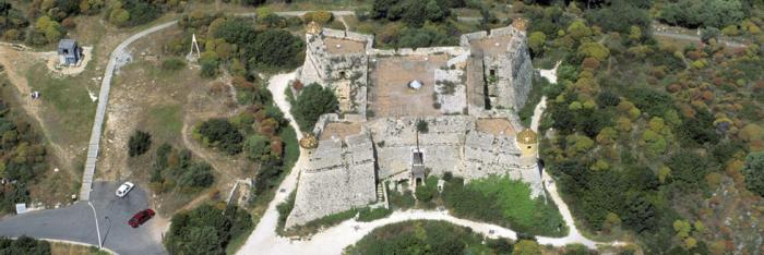
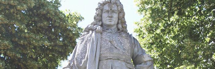
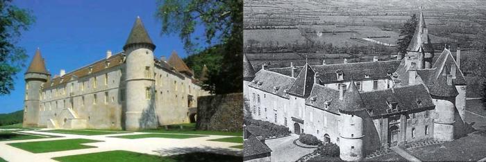
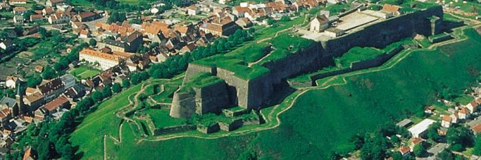
Ten kilometres from Vézelay, on the site of the ancient Roman road running from Sens to Autun, stands the Château de Bazoches, the former family residence of the Maréchal de Vauban, now a private property classified as a historical monument in 1994 and open to the public since 1997.


Built in the 12th century (around 1180) by Jean de Bazoches, the trapezoidal-shaped feudal castle comprises three round towers and a rectangular keep to which a larger tower with a wall-walk and machicolation was added in the 14th century.

Successively owned by the Seigneurs of Bazoches, Chastellux, Montmorillon and La Perrière, Bazoches was acquired by Vauban in 1675 thanks to an 80,000-pound gratification granted to him by King Louis XIV following the victorious siege of Maastricht (1673). The château had formerly been the property of Jacques Ier Le Prestre, the Maréchal’s grandfather, following his second marriage to Françoise de la Perrière, the Count de Bazoches’ illegitimate daughter whom he had recognised. After a confusing succession, Vauban’s father, Albin or Urbain Le Prestre, son of this second marriage, went broke and had to abandon the château to live in Saint-Léger-Foucheret.


When he moved into the château, Vauban made many changes and transformed it into a military barracks. In the recently restored Grand Gallery, Vauban, the father of military engineering, carried out studies and drew up plans for over three hundred constructions and fortresses and developed methods for attacking and defending fortifications, making him the unquestioned master of siege strategy and military architecture.

With a little imagination, it is easy to picture the frenetic activity that went on in this part of the château, from where Vauban’s instructions were sent out after completing his studies. Dispatch riders were constantly ready to head out for every corner of the country with the Maréchal’s plans and orders in metal cylinders. This required building vast stables that could house some fifty horses. It was also here that he thought out and wrote the twelve illustrated volumes of what he called, not without humour, his “idlenesses”, his reflections on a multitude of subjects such as agriculture, forests, coinage, sciences, etc.

We should also mention his many studies on the fiscal, economic and political issues of the times. His writings on the region and the “geographical description of the Election of Vézelay” (1696) bring together a great deal of information on the population and resources of the 55 parishes in the area.

With 14 proposals aimed at reducing the problem of poverty in this region of the Kingdom, the description provides important testimony on the French population and the mentality of the nobility at the beginning of the 18th century. It announces “the project for a Royal tithe” in which Vauban, observing the Kingdom’s extreme poverty and the inefficiency of the tax system of the day, proposes to raise a single tax and to unify the collection of the gabelle (salt tax). This novel text was published without legal authorisation in 1707, causing him to fall into semi-disgrace with the King.


The Maréchal actually spent very little time at Bazoches. He only came when he could take an exceptional leave of absence, notably in 1687, 1690, 1696, 1701 and 1704. He came to be with his wife and his two daughters, Jeanne, the younger, born on 28 October 1678, and Charlotte, the elder.

Vauban died at his family residence on 30 March 1707. He was buried on the following 16 April at the church in Bazoches, in Saint Sébastien chapel, which had been built upon his orders.


Today, the current owners, descendants of Charlotte de Vauban, carefully preserve many souvenirs of their illustrious ancestor among the rich furnishings, such as the Maréchal’s armour, considered a relic by Military Engineering Officers. Along with the 150-m² gallery which can now be booked to organise lunches or dinners, visitors can notably see Vauban’s antechamber and bedroom as well as his office, the yellow salon and the inner courtyard whose 17th-century decorations were recently restored.


Château de Bazoches

58190 BAZOCHES

Tel.: +33 (0)3.86.22.10.22

Fax: +33 (0)3.86.22.12.37

E-mail: chateau.bazoches@wanadoo.fr


You can visit on your own (guided tours are available for groups, upon written request). The visit takes about 1½ hours. The text of the tour is available in French, English, German, Spanish, Italian, Dutch and Japanese. The Château is fully furnished and heated


Opening hours and admission: see the Château de Bazoche website


Official website of the Château de Bazoches


> Return to results

Practical information

Address

Bourg Bassot 58190
Bazoches
Tél : 03.86.22.10.22Fax : 03.86.22.12.37

Prices

Adults: €8.00 Adults (with a ‘large family’ card): €6.00 Students (with card): €6.00 Children from 7 to 14 years: €4.00 Groups (> 20 people) : Adults: €6.00 Children from 7 to 14 years €4.00 Free for children under 7 and for the disabled.

Weekly opening hours

Open daily from 25 March to 5 November: 9.30 am to 12.00 pm and 2.15 pm to 6.00 pm (5.00 pm from 01/10) Guided tours in winter (6 November to 24 March) upon appointment.

The carriage of the armistice, Rethondes

Fit out, in 1922 by the architect Mages in collaboration with M. Binet Valmer, president of the league of the Veterans, the Armistice Glade will become a symbol of victory and peace...

November 11th 1918 at 5:15 a.m. the German plenipotentiaries accepted the armistice conditions of Marshal Foch. Some hours later at 11:00 a.m., the ceasefire announced the end of four years of horrible war. Fit out, in 1922 by the architect Mages in collaboration with M. Binet Valmer, president of the league of the Veterans, the Armistice Glade will become a symbol of victory and peace. Decorated by a monument for the inhabitants of Alsace and Lorraine ( piece of Edgar Brandt), it is pierced by an alley measuring 250 meters, leading to a sort of roundabout of 100 meters of diameter. It commemorates the end of the war, under the constant glance of Marshal Foch's statue.

Used for the signature of the armistice in 1918, the carriage n° 2419D was fit out in an office for Marshal Foch, by the Company "Wagons-Lits". Installed in 1927 on the glade, this symbolic wagon will be used by Hitler for the armistice of 1940 before being confiscated and burned in Germany in April 1945. Today the museum exhibits another carriage of the same series of 1913.
(...) When Marshal Foch had to determine the place, where he would call together the congressmen in charge for the armistice demand, he had many solutions. Would it be a more or less important locality? Would it be better to chose a place in the rear or a recently released region? Wasn't the Headquarter of the Commander-in-chief meant to be the place, where those who implored the suspension of hostilities had to be meet? (...) he will chose the forest of Compiègne, near the train station of Rethondes. Many times, during the war he established his Headquarter in his train. The congressmen will visit him at his headquarter. The loneliness of that place will ensure the tranquillity, the silence, the isolation and the respect of the adversary (...) Maxime Waygand, November 11th, 1932.
November 12th 1918, Marshal Foch addresses to his armies the following message: "Officers, Warrant Officers and Soldiers of the allied armies; after having resolutely stopped the enemy, during several month, you have attacked him without rest and tireless faith and energy. You just won the biggest battle of history and saved the a holy cause : the world's freedom. Be proud of an immortally glory, you have defended your national flags and the posterity will be forever thankful."
The Glade of the Armistice - 60200 Compiègne Phone number / Fax : 03 44 85 14 18 Opening : Opening From April to August 10h 18h last admission 5:30 p.m. daily September to March last admission 5:30 p.m. 10h 17h closed on Tuesday except school holidays price Adult : 5 euros Child rates 7-13 years : 3 euros

> Return to results

Practical information

Address

D546 60153
Rethondes
03 44 85 14 18

Prices

Adultes: 4 € Enfant de 7 à 13 ans et groupe de plus de 30 personnes: 2 € Groupe scolaire à partir de la seconde: 2 € Gratuit : Groupe scolaire jusqu’en 3ème

Weekly opening hours

Du 15 octobre au 31 mars: 9h à 12h et de 14h à 17h30. Du 1er avril au 14 octobre: 9h à 12h30 et de 14h à 18h

Fermetures annuelles

Fermé le mardi

Memorial of the landing in Provence, Mont Faron

The Memorial of the Mont Faron. © Ecpad

With the installation of a memorial, President Charles de Gaulle wanted to pay tribute to the soldiers of the B army.

- Télécharger la plaquette -

August 1944 in Provence.Creation of a second front after the landing June 6th 1944. August 15th 1944 the operation "Dragoon" on the coasts of Provence will take place. It aims to create a second front on the French territory. 2000 war pieces and as many planes will take part in it. The 7th American army of General Patch, including the French forces of the B army of General de Lattre de Tassagny, arrives in the night between August 14th and 15th on the French coasts. In Provence the resistance fighters are informed by Radio-London. Little after midnight, while the American Rangers reach the islands of Levant (region of the Eastern Mediterranean), the first French commandos take Cap Nègre and conquer a strategically vital localisation around Le Lavandou. During the night more then 5000 parachutists are released above the valley of Argens in order to block the access of the landing zones. Here they will get the support of the "Forces Françaises de l'intérieur".

At daybreak, an air and naval raid crushes the German batteries. At 8 a.m. the 3rd, 36th and 45th American infantry division (A.I.D.) reaches the coastal beaches between Cavalaire and Saint-Raphaël. The 16th the French forces start to land. While the American forces march up towards Durance and the valley of the Rhone, the B army must take Toulon and Marseille. These harbours are vital for the the allied strategy. August 20th Toulon starts to be surrounded. The Commandos and the Strike forces seize the batteries of the enemy, "Français Libres", Algerians, "Marsouins" of the Colonian Army and Senegalese try to take the city. The 9th Division of the Colonial Infantry (D.C.I.) will release Toulon from the occupying forces. On August 28th, the German garrison will surrender. At the same time de Lattre launches its troupes towards Marseille. The Moroccans take Aubagne. The 3rd Algerian Infantry Division (A.I.D.) of General Monsabert takes position at the suburbs of Marseille where the insurrection broke out. The 23rd of August, riflemen and cuirassiers join the resistant fighters. Five violent days of combats will be necessary to weaken the German defences. The two harbours were conquered one month in advance. From now on the French Armies will march towards the Rhone valley to contribute to push back the enemy.


The Mount Faron, dominates Toulon with its imposing silhouette. Therefore the town is also known as "The harbour of the Mountain". From the top of this 530m high mountain you can discover a vast maritime panorama, which extends from the islands of Hyères to the Bec d'Aigle de La Ciotat. Thus the visit of the memorial offers a beautiful touristic walk. The "Faron" can be reached either by cable car or by foot. The departure station of the cable car is located near the Hotzl "Altéa la Tour Blanche". It connects the public transports to the centre of the city. This overhead trip is prolonged on approximately 1 500m. From here you can discover the entire coast. This trip is a one-way street: from the west you reach the top of the hill and from the east you descend. Among the interesting tourist attractions, it is necessary to mention the zoo and the "chapelle Notre-Dame-du-Faron".


With the installation of a memorial, President Charles de Gaulle wanted to pay tribute to the soldiers of the B army (which became thereafter the first French Army) and commemorate the landing of the allies of 1944 in which the French troops took part. To locate this memorial, the Minister of "Veterans" proposes Toulon, since its seizure had a vital importance for the release of the Provence. Even if the location of the "Mount Faron" is isolated, it seduces anyone with its prestigious panorama. It's also a location of memory. Many combats took place here, in particular the fight of the battalion of the Strike Forces, August 21st and 22nd 1944. On the mount, which faces the great Basin viewing the sea, a little fort, intended to observe the Beaumont tower was once situated there. The architect Pascalet used its premises and added several buildings in order to create the memorial. This architectural piece was unveiled August 15th 1964 by General de Gaulle. During this ceremony an attack against the President of the Republic was fomented; the bomb, placed in a jar didn't explode.


Two main parts make up the memorial: the first is dedicated to the historical evocation. In many showrooms, pictures, models, arms and military uniforms recall the course of the different episodes of the landings. In an audiovisual room a 15 m large animated Diorama illustrates the coast of the Provence, from Anthéor to Marseille. Here it is possible to admire the most important operations, since the night of August 14th and 15th 1944 until the release of Marseille. A film concerning the landing is shown on a movie screen. The second part focuses more on the memory. The visitor has the possibility to remember all people who participated to the release: chiefs of government, allied soldiers, and resistance fighters... Many personal objects give an emotional touch to this exhibition. An anti-tank device, an anti-aircraft canon as well as a Sherman tank are symbolically positioned outside the building. On the low wall, which follows the hill towards the memorial, several commemorative plaques have been placed in memory to the combatants. Further, towards Croix-Faron a stele has been placed to commemorate the commanding officer of the Croix-Faron battery, who was killed during the combat of May 1940.


Memorial of the landings in the Provence Mont Faron

83200 TOULON

Tél. : 04 94 88 08 09 - Fax : 04.94.88.10.47


Le mémorial est ouvert tous les jours sauf le lundi

  • Du 1er octobre au 30 avril ouverture du mardi au dimanche

de 10 heures à 13 heures et de 14 heures à 17 heures 30


  • Du 1er mai au 30 juin ouverture du mardi au dimanche

de 10 heures à 13 heures et de 14 heures à 18 heures 30


  • Du 1er juillet au 31 août ouverture 7 jours sur 7

de 10 heures à 13 heures et de 14 heures à 18 heures 30


  • Du 1er au 30 septembre ouverture du mardi au dimanche

de 10 heures à 13 heures et de 14 heures à 18 heures 30


Toute l'année la caisse est fermée une heure avant les heures de fermeture.


visitvar


Natura 2000

 
> Return to results

Practical information

Address

83200
Toulon
04 94 88 08 09

Weekly opening hours

Reopening to the public in spring 2017

Parc du Morvan

Paysage du Morvan. ©www.fr.academic.ru

In the 20th century the Morvan, the homeland of Marshal Vauban, was a sanctuary for members of the Resistance in their fight against Nazism and would favour the development of the maquis underground movement.

Covering 300,000 ha, the Morvan regional nature reserve, which was created in 1970, currently includes 117 communes 5 cities partners for a population of more than 74,000. The Morvan relief is situated in medium mountains and rests primarily on a granite base and, on the outskirts, on calcareous soil. The landscape consists mainly of farmland criss-crossed by hedges and prairies, forests with broad-leaved trees and conifers, a permanent presence of water (lakes, ponds, rivers, streams), of granite and of the buildings constructed out of the latter. If the scenery is the mark of man, buildings tell a lot about his history. The Eduens (a Gallic tribe) and the Gallo-Romans considered the Morvan to be an important area as testified by Bibracte - today the largest archaeological site in Europe dedicated to the Celtic civilisation - and Autun. Roman art is well represented thanks to the treasures discovered in Vézelay, Saulieu and Autun. The roads of Morvan are surrounded by castles, churches, chapels, places of worship and stones of legend, as well as a multitude of smaller heritage sites.

Dedicated to the theme of exchanges and migration, the eco-museum of Morvan, with its 5 sites each focusing on a specific theme, will take you on a journey of discovery through the history and soul of the MORVAN. One of these sites, located in Saint-Léger-Vauban, is devoted entirely to Vauban. He was born in the region and spent his formative years there, forging his personality to become not only the Marshal that we know about but also a great humanist as proved by his writings, the most famous of which is 'the project for a royal tithe'. In this work, he notes the poverty of the kingdom and the ineffectiveness of its tax system, and proposes the introduction of a single tax. This work, which appeared in 1707, was condemned by Louis XIV and left its author in disgrace. A museum founded in 1983, located at the Saint-Brisson site, is also dedicated to the Resistance in Morvan. The hills, forests, twisting ancient paths and the spirit of the locals, the morvandiaux, made the Morvan a perfect place for members of the Resistance to take refuge. In 1944, there were more than twenty maquis in the Morvan, spread over an area of 150 km². With its well preserved landscape, specific historical riches and diverse heritage, the Morvan is and always will be a place of sanctuary.
The Saint-Brisson site is located on a property covering 40 ha, with buildings that date back to the beginning of the 19th century. It contains the 'Maison du Parc', which serves as the administrative centre of the Morvan regional nature reserve, the 'Maison des hommes et des paysages' (the name of the Morvan eco-museum) and the Resistance Museum. Contact: Parc naturel régional du Morvan Maison du Parc 58230 SAINT-BRISSON Tel.: 33/ (0)3 86 78 79 57 Fax: 33/ (0)3 86 78 74 22 E-mail:parcmorvan.ot@wanadoo.fr

> Return to results

Practical information

Address

58230
Saint-Brisson
Tél. : 03 86 78 79 57Fax : 03 86 78 74 22

Weekly opening hours

Accessible toute l'année