Newsletter

Le fort du Réduit, Lille

Fort and Chapelle du Réduit, Lille from the belfry of Lille. Source: ©VIGNERON - License Creative Commons - Free of rights

The Fort du Réduit, formerly called Fort Saint-Sauveur, was built by Vauban between 1671-1674 .


The purpose was to strengthen fortifications south of the town and to make an impression on the working-class population of Saint-Sauveur who were becoming troublesome. It was used to store weapons and had a small garrison with a commanding officer, like at the Citadel.

Fort Saint-Sauveur was decommissioned in 1859. Because of this, only a few buildings and a classical-style chapel dating from 1707, built in white stone from Lezennes are all that remain. Only a few additional constructions have been added since 1947.


The Fort still accommodates military engineering services today.

> Return to results

Practical information

Address

42 rue du magasin 59800
Lille

Weekly opening hours

Ouvert uniquement lors des journées du patrimoine

"Museum of the 5th of June 1944, the ""Verlaine Message"", of Tourcoing"

Façade du Musée. Source : Archives de Tourcoing.

The World War II Museum is located in the German 15th Army staff headquarters’ command bunker, a rare SK1 model.

The World War II Museum is located in the German 15th Army staff headquarters’ command bunker, a rare SK1 model, which they occupied in Tourcoing from 1941 to 1944.
 
On 5 June 1944 at 9.15 pm, in this bunker camouflaged with brick facing to protect it from Allied bombing, the "Verlaine" message ("Les sanglots longs des violons de l'automne blessent mon coeur d'une langueur monotone") was heard and analysed by the Germans as announcing the Normandy landing of 6 June 1944.
 
This museum evokes various aspects of the Second World War: the Atlantic Wall, the war of the airwaves between the occupying forces and the resistance fighters, the operations of the staff headquarters and, every year, a topical exhibition on military operations during the war. Many victims are included in this approach to the duty of remembrance, attached to the evocation of the battles and tribulations of those who suffered and struggled for freedom and the defence of civic values.
 
 
The Museum is located at 4 bis Avenue de la Marne, as you come into Tourcoing on the "Grand Boulevard", coming from Lille.
It is open on the 1st and 3rd Sundays of the month, from 9.30 am to 12 pm and from 2 pm to 6 pm.
Groups can book visits during the week by calling (tel.: +33 (0)3.20.24.25.00)
Free admission for children under the age of 10.


Source: Préfecture du Nord
> Return to results

Practical information

Address

4 Bis Avenue de la Marne 59200
Tourcoing
03.20.24.25.00

Prices

Admission: Adults: €4.50; 10/15 years: €2.50; Under 10: free Groups (10 people and more): €3.50

Weekly opening hours

Opening hours: Guided tours the 1st and 3rd Sunday of each month, 9 am to 12 pm and 2 pm to 6 pm. By appointment for school groups. Duration: 1½ hours

The Noble Tower Resistance Memorial

The Noble Tower now houses the Resistance Memorial. Source: © Office de Tourisme de Lille – Photo: © Damien - Zoom sur Lille

The Noble Tower holds an urn containing the ashes and remains of prisoners who were deported and cremated in the death camps. The cover of the urn bears the names of these camps.


Built at the beginning of the 15th century (in 1402), the Noble Tower was completed under King Philippe the Good. Designed using regional materials (Lezennes stone), it is covered with earth for protection against the cold and fire, with a width of 14 m and walls that are 3-m thick. The masonry and mouldings date from the Burgundy period. The “Noble Tower” has existed for 6 centuries.

Destroyed during Louis XIV’s siege, it was restored by Vauban. The upper section is missing, however, as is the ground floor, which has been buried. Inside we can admire the gothic vault and the urn symbolising the Martyrdom of the Deportees.


The urn inside the Noble Tower contains the ashes and cremated remains of deportees who were horribly murdered in the death camps. The cover, in bronze, bears the names of the camps in raised lettering.

Departmental Resistance and Deportation Memorial
Rue des Déportés in Lille

The site is open to the public during commemorative events, such as the last Sunday in April each year for the Deportation Commemoration Day and for the Historic Monuments Open House Days in September.

Information: for group visits, contact the Cultural Service at +33 (0)3 20 49 52 81.

Lille Tourism Office
Palais Rihour Place Rihour BP 205 59002 LILLE Cedex

Tel. from France: 0891 56 2004
Tel. from abroad: +33 (0)359 579 400


Website of the Regional Tourism Committee of the Nord region


Website of the Nord Department Tourism Committee


Website of the Lille Tourism Office


Quiz: Forts and citadels

> Return to results

Practical information

Address

rue des déportés 59000
Lille
service Culturel au 03 20 49 52 81 Office du Tourisme de LillePalais RihourPlace RihourBP 20559002 LILLE CedexTél. depuis la France : 0891 56 2004

Weekly opening hours

visite le dimanche de 15 h à 17 h, d'avril à novembre et sur rdv.. Mémorial accessible au public le dernier dimanche d'avril, la Journée de la Déportation et les journées Portes Ouvertes des Monuments Historiques en septembre.

Cambrai

La Nécropole allemande de Cambrai. Photo Licence Creative Commons. Libre de droit

The German Necropolis in Cambrai.

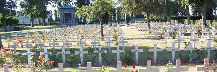
The cemetery on the Route de Solesmes

Located on the road to Solesmes, this cemetery not only evokes the fate of this town, occupied by the Germans from 26 August 1914 to 9 October 1918, but most importantly the first battle of Cambrai, from 20 November until 3 December 1917, the German offensive of March 1918 and this second battle of Cambrai, the last battle on the Hindenburg line, which was to finally liberate the city in October 1918, the town by then having endured terrible destruction.


Later the town was "adopted" by the County Town of Birkenhead. The cemetery had been created by the Germans during their occupation from March 1917. They had constructed a few monuments and a stone cross there. On 11 August 1918, the Bavarian commander of the town had handed over the maintenance of the cemetery to the town. Afterwards the German Military cemetery that was in Cambrai was transferred there to the Saint-Sépulcre cemetery. The graves have now been regrouped. The remains of 10,685 Germans, 192 Russians, 6 Romanians and 502 British are to be found there.

13 km to the north east of Bapaume on the road between Cambrai and Bapaume is the Louverval Memorial. It commemorates the 7,048 British and South African soldiers who died at the Battle of Cambrai in November and December 1917 and whose graves are unknown. The Battle of Cambrai, marked by a breakthrough on 20 November, a cessation on positions on 22 November and a German counter attack between 23 and 29 November, resulted in a limited gaining of ground but taught the Allies some valuable tactical and strategic lessons. For their part, the Germans had discovered that their line of defence was vulnerable. The Memorial, situated on a terrace at the far end of the military cemetery, was designed by H. Chalton Bradshaw and the sculptor C.S. Jagger, whose two bas-reliefs illustrating battle scenes are to be admired.


1917 had been a terrible year for all the fighting nations during the ongoing First World War. At the end of the year, the British, seeking to destroy the Hindenburg line (the defensive system for the territories occupied by the Germans), decided to launch an offensive to the south of Cambrai involving the large-scale use of tanks. The battle was merciless: the first battles were a great success for the British troops, except at Flesquières, but the Germans, at first thrown into confusion, very quickly started a powerful counter-offensive. For 15 days, attacks and counter-attacks were to follow in succession, with neither of the two armies chalking up decisive success. The human losses were enormous: 45,000 British and 55,000 Germans were killed, as whole villages were destroyed. During the First World War, a new weapon appeared on the battlefields: the tank. Tanks were designed to support the attacks of the infantry, driving them across enemy lines. During the battle in November 1917, the "Tank Corps" of the third British Army (a total of 476 tanks) was engaged to break through the Hindenburg line.


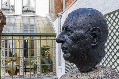
The objective of the battle was to take the strategic positions of the Flesquières ridge and the Bourlon woods before targeting the liberation of Cambrai. At Flesquières, the British attack came up against fierce resistance from German troops, who managed to destroy or immobilise several tanks. One of those destroyed was buried by the Germans in the spring of 1918. In November 1998, thanks to a handful of enthusiasts, it was unearthed. Today this war relic can be seen in Flesquières. At Cambrai, the memory of this battle lives on through the monument to the soldiers from the Cambrai regiments, opposite the gate to the citadel and through the French Remembrance monument listing all those from Cambrai who died in combat during the Great War. The Louverval cemetery is an important place of remembrance for them.


Characteristics: - 26.5 tonnes - 8.50 metres long - 3.20 metres wide - 52 cm wide tracks - 5 machine guns with 13,000 to 30,000 cartridges - Crew of 8 men.
It was on the Flesquières ridge that the most important episode of the Battle of Cambrai took place. Overlooking the valley, it is possible for us to imagine the starting point of the British attack on 20 November 1917, on a front of about 8 km stretching from Havrincourt to Bonavis. There used to be a mill there, but since it could be used as a reference point for the British artillery, it was destroyed by the Germans. Today there is a project to build an orientation table showing the Hindenburg line's defensive system and erect a monument to the glory of the soldiers who fell on the battlefield.


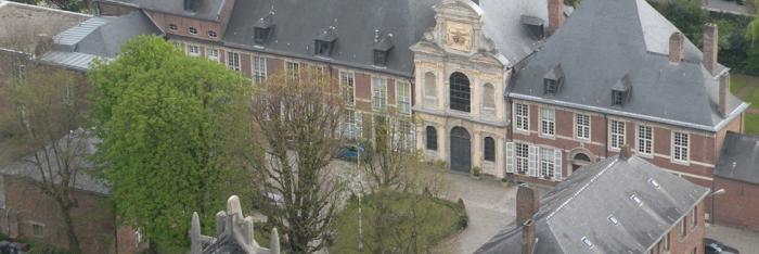
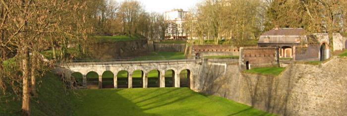
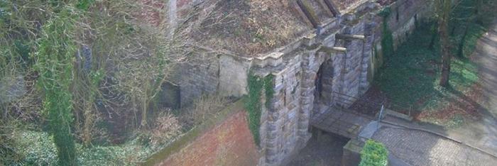
This raised German bunker is characterised by its shape and its use, as it served as an observation tower. In fact, its position allowed communication with Cambrai using visual signals. The observation post was attached to the château garden. The building is still very well preserved today.


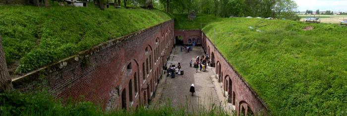
An exact replica trench was created for the filming of the documentary "he Trench" by the BBC. Tours of the site are possible on request to complement a tour of the tank.


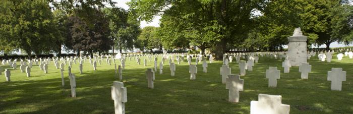
Flesquières Hill British Cemetery

In this cemetery, as in all those with more than 400 graves, the Commonwealth War Graves Commission has built a "Remembrance Stone" on which is engraved the inscription "Their Name Liveth For Evermore". In addition, the cemetery contains the graves of 589 known and 332 unknown soldiers. Next to the British are buried the soldiers from New Zealand and Australia who took part in the fighting at the end of the war.


Orival Wood British Cemetery

The remains of the famous English poet, Lieutenant Ewart Alan Mackintosh are buried here. In the same place there are also the graves of Canadian and German soldiers killed in the Flesquières sector.

> Return to results

Practical information

Address

Route de Solesmes 59400
Cambrai
Tél: 03.27.73.21.00Fax: 03.27.73.21.01

Weekly opening hours

Accessible toute l'année

Maison natale Charles de Gaulle

© MNCDG / CD59

Charles de Gaulle a vu le jour au 9, rue Princesse à Lille dans la demeure de ses grands-parents maternels, le 22 novembre 1890.  


Consulter l'offre pédagogique >>>  © MNCDG / CD59


Cette maison fut le lieu de retrouvailles familiales pendant toute son enfance et sa jeunesse. C’est dans une famille unie autour de valeurs communes (patriotisme, ferveur religieuse, sens de l’engagement…) et dans un contexte géopolitique en plein bouleversement, que s’est forgé le caractère du futur Président de la Ve République.

Monument historique, la Maison natale Charles de Gaulle a pour vocation de faire découvrir à un large public l’enfance et la genèse de celui qui deviendra le plus illustre des français.

La Maison natale Charles de Gaulle a fait l’objet d’une campagne de travaux de grande ampleur en 2020 qui a permis de conforter la structure de l’habitation mais aussi de la rénover complètement (décors restaurés, pièces de vie réhabilitées, jardin d’hiver restitué…). La maison recrée l’ambiance d’un intérieur caractéristique de la bourgeoisie industrielle du Nord à la fin du XIXe siècle telle que Charles l’a connue enfant.

Une visite 100 % immersive !


> Return to results

Practical information

Address

9 rue Princesse 59000
Lille
03 59 73 00 30

Prices

6 euros avec audioguide compris / Gratuité : Pour les moins de 26 ans, pour tous, chaque jour en « Happy hour » de 17h à 18h, le 1er dimanche du mois

Weekly opening hours

Tous les jours (sauf le mardi) de 10 h à 18 h

Fermetures annuelles

Fermé le 1er janvier, 1er mai, 25 décembre et le week-end de la braderie de Lille

Condé sur l'Escaut

Condé sur l'Escaut, the ramparts and the étang de Chabaud Latour. Source: http://lesjoyeuxgodillots.fr

The fortifications of Condé sur l'Escaut.


Only some 350 m of the medieval walls on either side of the Vautourneux Gate remain, comprising earthen ramparts doubled with a ring of towers and curtain walls that protected Condé until the middle of the 17th century. On one side, at the two ends of the earthen rampart wall, Archers Tower and Plovière Tower overlook the Nervien ditches. On the other side, the less impressive wall was defended by the Capucins Tower, rebuilt in 1623 and equipped with cannon firing ports strangely placed at ground level. Further on, the Touquet bartizan is set in an inside corner. We should also mention the so-called "Arsenal" fort and the Hotel de Bailleul, dating from the 15th century, with 4 turrets.


La fortification bastionnée remonte à l'époque des Pays-Bas, des conquêtes espagnoles et la décision prise en 1654 d'ériger la cite en place forte pour faire face à Louis XIV. Les Espagnols commencent à établir une fortification bastionnée au nord puis au sud et au sud-est. En 1674, les travaux étaient terminés, bastions, courtines, fossés et glacis, tout cela en terre, il est vrai mais en 1676 les quatre principaux bastions étaient muraillés.


Après la prise de Condé par Louis XIV en 1676, des améliorations sont apportées par Vauban : construction de contre gardes, renforcement de la redoute du Jard mais surtout il s'employa à murailler ce qui ne l'était pas encore. Le canal du Jard servait en partie de fossé de fortifications, en partie de canal d'inondation.

The bastioned fortification dates from the Netherlands period, the Spanish conquests and the decision taken in 1654 to make the city a stronghold against Louis XIV. The Spaniards began with a bastioned fortification to the north, and then to the south and southeast. The work was completed in 1674, with bastions, curtain walls, moats and glacis, all in earthenwork, but in 1676 the four main bastions were walled off.

Vauban made improvements after Condé was taken by Louis XIV in 1676, building counterguards, reinforcing the Jard redoubt, but he especially worked to build walls in areas that had not yet been walled off. The Jard Canal was partially used as a fortification moat and partially as a flood canal.

Today there remain eleven hectares (27.5 acres) of fortifications including the Jard, Solre, la Teste (or Royal) and Tournai bastions with ravelins and counterguards. Under the glacis of the Tournai ravelin there are countermines dug by the Austrians in 1794. The stronghold was decommissioned in 1901 and dismantled in 1913. Walking paths have been laid out to visit the ramparts and the Tourism Office organises guided tours. The city is a member of the association for fortified cities of the Nord-Pas-de-Calais region.


Valenciennois Tourism Office

"Le Beffroi" 26, place Pierre Delcourt 59163 Condé sur l'Escaut

Tél : 03 27 28 89 10

Fax : 03 27 28 89 11

Courriel : otduvalenciennois@wanadoo.fr


Quizz : Forts and citadels

> Return to results

Practical information

Address

59163
Condé-sur-l'Escaut
Tél : 03 27 28 89 10Fax : 03 27 28 89 11

Weekly opening hours

Accessible toute l'année

Assevent National Cemetery

Assevent military cemetery. Source: Ville d’Assevent


Click here to view the cemetery’s information panel vignette Assevent

Maubeuge, located at the intersection of railway lines that, coming from Brussels and Liège, converge towards Paris – was a major strategic goal for both the French and the Germans.

In accordance with the Schlieffen plan, German troops entered Belgium on 4 August 1914, and Maubeuge was on their way there. On 29 August, the Germans set off a powerful bombardment. After eight days of siege, Maubeuge was still resisting, but the situation turned highly critical from 6 September. On 7 September, General Fournier, the Governor of Maubeuge, had to capitulate. The Germans took 450,000 prisoners and 450 guns and 80,000 shells.

During the war, Maubeuge was controlled by the German military administration in occupied Belgium. It was only released on 9 November 1918 by British troops.

The Assevent National Cemetery, located 5km from Maubeuge, is home to the bodies of soldiers who died for France during the Siege of Maubeuge in August 1914.

Established in 1916 by the German army, the cemetery was redeveloped in 1923 to gather the bodies of other soldiers killed during the battle that were exhumed from temporary cemeteries in the Nord department or from Ypres in Belgium. The cemetery holds 1,819 bodies, including 364 in individual graves and 990 in four ossuaries, which is likely to include a large number of Moroccan infantrymen. There is a German military cemetery on the other side of the railway line. It was built in 1924 and comprises of 998 bodies of soldiers who fell in September 1914 around ​​Meaux (Seine-et-Marne).

The Assevent National Cemetery was established by the Germans during the war and seems to reconcile German, French, Russian and British soldiers in death.

> Return to results

Practical information

Address

59600
Assevent

Weekly opening hours

Open throughout the year

Maubeuge

The ramparts (fixed bridge). Source: http://www.maubeugelibre.fr

The ramparts of Maubeuge.


Clearly visible from Place des Centenaires, the ramparts of Maubeuge, which date to Vauban's time, are an ideal site to visit. Only one gateway remains, the Mons, but its drawbridge and pediment have many interesting features. Nearby is the guardroom, which is similar to those on some of Vauban's other ramparts and structures.


There is a fortification museum here.
The town suffered greatly in the Second World War. The architect Lurçat was in charge of reconstruction.
 
There are several slabs and plaques in commemoration of the two world wars. In the cemetery, there is a monument dedicated to soldiers from Maubeuge who fought in the war of 1870. There is a monument in memory of the French revolution on Place Vauban, site of the monument commemorating the battled of Wattignies, thanks to which the siege of Maubeuge was lifted. Jean-Baptiste Jourdan and Lazare Carnot are notably remembered. Close by, a 1917 Renault tank is on display.
 
 
Museum of fortifications
 
Visits on Sundays from 3 pm to 5 pm, from April to November, and by appointment.
 
Tourist Information Office: +33 3.27.62.11.93


Website of the regional tourist board for the Nord


Quizz : Forts and citadels

> Return to results

Practical information

Address

59600
Maubeuge
Ofice du tourisme : 03.27.62.11.93

Weekly opening hours

visite le dimanche de 15 h à 17 h, d'avril à novembre et sur rendez-vous.

The Citadel of Cambrai

Royal Gate at the Citadel of Cambrai. Source: http://www.aspecambrai.org

The Citadel of Cambrai, a unique example of the fortresses built by Emperor Charles V.

The city of Cambrai held the position of border city between the Kingdom of France and the Holy Roman Empire from the Carolingian period. Very early on it therefore had to build a ring of fortifications that were expanded and developed over the centuries with the evolutions in siegecraft. The decision to dismantle the fortifications was taken at the end of the19th century. Nonetheless, the city has kept some remarkable remnants of its fortified past. Of the medieval fortifications, several towers remain, along with the gates of the Front Sud, from the end of the 19th century: Arquets Tower, which is the water gate letting the Escaut flow into the city, Caudron Tower, equipped with a turret made of Bouchain sandstone since the 19th century, Saint Fiacre Tower located along the former curtain wall, and the Paris Gate, which has preserved some traces of the defence system.

In 1543, Emperor Charles V tore down a major abbey in Cambrai, Saint-Géry au Mont des Boeufs, to build a citadel using the new principles of bastioned military architecture. Although it was dismantled at the end of the 19th century, this citadel, a unique example of the fortresses built by Charles V, still has its countermine galleries for the surveillance of the ditches, the Royal Gate with rustic bossage decorated with a lion and an arsenal dating from the 16th century.
Among later installations, the officers’ lodgings from the 18th century have been preserved, explosive magazines and barracks that were able to withstand the bombs of the 19th century. Notre Dame Gate, built in 1632 at the north entrance to the city, is remarkable in its decoration.


Paris Gate, the former Saint Sépulcre Gate

A testimonial to the ramparts built at the end of the14th century, this was the only way to reach the south of the city until the fortifications were dismantled starting in 1892. This strategic position had to be invulnerable in case of a siege. The arrowslits on the towers, the drawbridge, the portcullis, the murder-holes in the vault and the large upstairs guard room ensured the Gate’s defence when attacked.

Cambrésis Tourism Office

Maison Espagnole

48, rue de Noyon

59400 CAMBRAI

Tél : 03.27.78.36.15 Fax : 03.27.74.82.82

E-mail : contact@tourisme-cambresis.fr


Quiz: Forts and citadels

> Return to results

Practical information

Address

Boulevard Paul Bezin Porte Royale de la Citadelle 59400
CAMBRAI
Tél : 03.27.73.21.00 Fax : 03.27.73.21.01

Weekly opening hours

Accessible toute l'année

Seclin

Fort de Seclin. Source : https://fortseclin.jux.com

Seclin fort, cavalry and artillery museum.

Apart from the architectural masterpieces of the old hospital and the collegiate church, the town of Seclin also boasts a Séré de Rivières Fort that was part of the fortifications designed to protect the City of Lille and the surrounding area. But it could not keep pace with the development of late 19th century artillery and could not withstand the effects of the new projectiles. Occupying a commanding position in the Mélantois area, overlooking the valleys of the Marque and the Deûle, to the West it could rely on support from the Englos Fort above the Deûle and to the East on the fort at Sainghin en Mélantois that overlooked the Marque; but the distance of almost 10km between each of these forts was less than ideal in putting this principal effectively into practice. However, intermediate fortifications were supposed to link these forts and form advance strongpoints outside the Lille area: Enchemont, Vendeville, Noyelle, Houplin, Haubourdin (Moulin Neuf). To complete the system, mobile and fortified batteries were to be installed above the intermediate batteries that were protected by earth fortifications. The final fortifications were built in 1894. None of the required modernisation and finishing touches were carried out. This led, on 4th August 1914 to Lille being declared an open city.

After 1918, Seclin Fort was used to store artillery ammunition. Bondues was used as a barracks, and Englos as a fuel depot. In 1939, an anti-aircraft battery was stationed at Englos. Throughout the Second World War, these forts were the scene of resistance operations against the occupying forces, the history of which are recorded on stele. Seclin Fort has now been gradually and skilfully restored by the private owners, who have built up a collection of artillery and gun carriages.


Fort Seclin F-59113 Seclin Tel: +33 3 20 97 14 18 e-mail: museum@fortseclin.com Open: Weekends except holidays 2-6pm Other times by appointment (min. 5 people) Prices: Children €4, adults €5 Seclin Tourist Office Tel: +33 3.20.90.12.12

> Return to results

Practical information

Address

Chemin du petit fort 59113
Seclin
Tel : 03 20 97 14 18 La Maison du Tourisme de SeclinTel :03.20.90.12.12

Prices

Tarifs : 4 €/enfant - 5 €/adulte

Weekly opening hours

Week-ends sauf jours fériés 14h/18h Autres moments sur RDV (min de 5 pers)