Newsletter

The Fort de la Croix de Bretagne

The Fort de la Croix de Bretagne. Source: ECPAD

The Fort de la Croix de Bretagne was built at the end of the 19th century to protect the borders of the French alpine valleys, under threat from Italy.

The Fort de la Croix de Bretagne is one of three independent forts planned by the Defence Committee when reorganising the defence of Briançon after the invention of rifled artillery. Constructed between 1876 and 1879, it is a perfect example of the necessary adaptation of military architecture to the most difficult rugged terrain. It was complemented by the Grande Maye, a position designed to prevent the breaching of the position of the Gondrans and protect the borders of the French alpine valleys under threat from Italy.

The fort is a long, narrow construction, protected by square towers. It occupies a steep crest that culminates at 2,016 metres, rising up the slope in several tiers connected by an internal twisting road. It provides an unobstructed view over the Fort des Têtes and Mont Prorel. The garrison of four hundred and ninety six men was billeted in a two storey casemated barracks and an officers' lodge. Building B, also casemated and open on two sides, was used as a stable for forty horses, an infirmary that could accommodate 10 patients and a bake-house.
Commissioned on the 25th July 1879, the armaments included seven 155 pieces, five 138's, four mortars distributed across the artillery platforms and twelve canons. The largest one, at the top of the fort, fired across the plateau of the Gondrans. Kept in service until 1940, the fort still belongs to the military sector.

> Return to results

Practical information

Address

5100
Briançon
04 92 21 05 27

The redoubt of les Salettes

Fort des Salettes vu de Briançon. Source : ©MOSSOT - License Creative Commons - Libre de droit

Designed by Vauban after his first visit in 1692, it is situated above the high town on the first of the twisting roads that lead to the Croix de Toulouse.

The town of Briançon, a stronghold on the Durance, did not escape Marshal de Vauban's wisdom. He endowed the town with a citadel and fortified it by installing defence positions on the hills, such as the redoubt of les Salettes which started a tradition of fortification that would see the installation of new defence structures at up to 2,500 m during the 19th and 20th centuries.

Vauban in Briançon: fortifying the town "in a modern way". Fortification project in 1692. The site appeared a difficult one for him to develop, as it was surrounded on all sides by high hills: "You can't imagine anywhere more uneven, with mountains reaching up to the skies and valleys descending into the abyss..." (Vauban in 1692). The town was already protected by a crude wall, built by resident engineer Hue de Langrune between 1689 and 1691. Closely resembling a medieval curtain wall, it had no external fortifications. In his eyes "as the town's new wall was built with a view to protecting it from the affronts of the Barbets and not to withstand a well-planned siege...", there was still everything to do. On the 21st November 1692, he drew up his project for the fortifications to be built in the town and at the château of Briançon. He requested the construction of two demi-lunes, as well as a false bray on the Embrun front. This structure, necessary because of the steep incline, is a kind of step set below the bastioned trace, which provides the potential for more effective grazing fire. He stipulated various developments: the deepening of the moats, the consolidation of the curtain walls, the installation of guard houses, the creation of port holes, traverses and posterns, the vaulting of the gate and the construction of powder stores. To spare the residents from having to provide accommodation for the soldiers, he planned the construction of barracks. Vauban was also concerned about the problem of providing water, as all the sources supplying the town came from outside. He requested the deepening of the well in the Place d'Armes. Vauban considered a significant project for the château, but then abandoned it. On the one hand he feared he would not obtain the necessary funding and on the other, Briançon, although far from the border, was already protected by other strongholds.
Controlling the progress of the work and adapting the projects. Memo of 1700. During his second trip to Briançon, Vauban inspected the work and released a new memo, dated the 24th August 1700, taking into account the loss of the stronghold at Pignerol: "The significance of this place has greatly increased since the destruction of Pignerol" (Vauban in 1700). He envisaged an enlargement of the town under the Embrun gateway, in order to house all the military buildings, as the small size of the town did not allow it to be built within the ramparts (a project that was not followed up). He recommended the erection of a bridge over the Durance, the creation of a road to Montgenèvre, the occupation of the Plateau des Têtes and the construction of a redoubt on the Montagne des Salettes. He drew up 99 articles about the château before finally concluding "that it would be far better to totally demolish this bad old dinosaur... and rebuild everything from scratch". The slow progress of the work led local engineers to take the liberty of making alterations, which enraged Vauban, in particular the project for a counterguard, about which he wrote in 1704: "I see a kind of false bray or covered walkway... which up to now has not been mentioned in the overall project... I note with surprise that Lord Guillyn has taken great delight in adding, removing and altering whatever he likes... if I was younger I would offer to go there from time to time and put it all right ."
Securing the hills Projects for the château Vauban gave this description of the château de Briançon during his first trip in 1692: "The château sits on a high, naturally steep rock above the town, ..., its old enclosure is only two and a half feet thick and is not even terraced... the four towers are quite good (...) in the château (...) there is only one old large square tower with three floors that are used as stores and an arsenal, (...) a guardhouse, a small water tank in poor condition, two or three old outbuildings about to fall into ruin, ten old and six modern barrack rooms, practically no well or latrines and a very poor gate that has neither tread boards nor a drawbridge..." Vauban thus strengthened the existing structure and ordered improvements: a second water tank, latrines and basements.
The redoubt of les Salettes In his first project, Vauban suggested the creation of a machicolated redoubt on the Montagne du Poët. The structure was designed to prevent the enemy from taking this town with its important commanding position over the town and the château. It is highly likely that Vauban took up a suggestion of the engineer Delabat dating from January 1692. In February 1704, he complained that work had not yet begun. It would not start until 1709, two years after Vauban's death, under the supervision of the engineer Tardif and would continue until 1712. The fort looks like a reduced tower, surrounded by a moat and a counterscarp with a reverse fire gallery. Its uniqueness is in the fact that access to the gallery is only possible via a basement leading from the reduit. The tower itself is a square building with graduated sides, on two levels, covered with a pyramid shaped roof. Access is via the first floor across a footbridge over the moat. The barrel-vaulted reverse fire gallery prevented the enemy from breaching the interior moat. Under the reign of Juillet, this redoubt would be converted into a fort by the addition of a bastioned outer defence line (envelope), six Haxo-type casemates and a powder store. The tower would be reinforced with a terraced roof and better equipped with artillery. Continuing Vauban's work: protecting the new border. The end of the reign of Louis XIV was marked by the war of the Spanish Succession from 1701 to 1714, when, once again, France was in conflict with part of Europe. The Briançon area became a place of confrontation between the French and the Savoyards. In 1713, the Treaty of Utrecht brought an end to some of the hostilities. Unfortunately, it turned out to be disastrous for the land of the Escartons. The border, which up until then had been well beyond the mountains, was moved to the watershed in the Montgenèvre pass. France lost Val Cluson, la Varaïta and part of the Val de Suse, receiving in exchange the Ubaye. The town thus became a border zone which required protection. The construction of a veritable barrier of forts began under the Regency in July 1721 and continued for thirteen summers under the reign of Louis XV. Claude François Bidal, Marquis Marshal of Asfeld, a follower and the successor of Vauban, would be in charge of the work as Director General of the fortifications of France. As reinforcements for the fortifications of the town and of the redoubt of les Salettes, seven "Vauban style" fortifications would be built around the town: the Trois-Têtes, Randouillet, Dauphin, and Anjou forts, the Point du Jour redoubt, Communication Y and the Asfeld Bridge.
The redoubt of les Salettes Route de l'Italie 05100 Briançon Tel.: + 33 (0) 4 92 21 08 50 Fax : + 33 (0) 4 92 20 56 45 Guided tours are provided by lecturers from the heritage department Town of Briançon - Heritage Department Porte de Pignerol 05100 Briançon Tel: + 33 (0) 4 92 20 29 49 Fax: + 33 (0) 4 92 20 39 84 E-mail: patrimoine@mairie-briancon.fr The Club du Vieux Manoir restores and hosts activities during the summer season in the Forts of les Salettes and the Château, which belong to the town. The ancient Abbey du Moncel 60700 Pontpoint Tel: + 33 (0) 3 44 72 33 98

> Return to results

Practical information

Address

5100
Briançon
04 92 21 08 50

Prices

Plein tarif: 6-7 € Tarif réduit: 4,50-5,50 € Gratuit : Enfant de moins de 12 ans

Weekly opening hours

Du 18 au 30 juin et du 1er au 18 septembre: le mercredi, jeudi et vendredi de 11h à 18h. Du 1°Juillet au 31 Août: tout les jours sauf le dimanche, de 11h à 18h

Fermetures annuelles

Fermé du 18 septembre au 18 juin

The Mont-Dauphin citadel

Mont-Dauphin, place fortifiée par Vauban. Source : GNU Free Documentation License

Entirely built by Vauban from1693 onwards, the citadel was intended to prevent access from the Valley of the Durance by the troops of the Duke of the Savoie.

Entirely built by Vauban from1693 onwards, the Mont-Dauphin citadel was thus named in honour of the son of Louis XIV. It was intended to prevent access from the Valley of the Durance by the troops of the Duke of the Savoie.

Opposite the Fort des Salettes, at the foot of the Col de l'Infernet, it is a fortification on several levels with two fortified sides, positioned on a rocky promontory (1400 m) offering imposing natural defences. Its peculiarity comes from an imposing wall (2.20 m wide by 9.30 m high), which crosses the fort lengthwise, backed onto by the only barracks building. This advance post, built on the edge of a forest, watched over the Vallon du Fontenil and protected the Fort des Têtes. With its outlook it allowed the Fort des Salettes to completely secure the route from Italy.
The Mont-Dauphin citadel 05100 Briançon Mont-Dauphin Tourist Information Office Tel.: +33 (0) 4.92.45.17.80

> Return to results

Practical information

Address

5100
Briançon
04 92 45 42 40

Prices

Plein tarif: 7,50 € Tarif réduit: 4,50 € Groupe (+ de 20 personnes) : 6 € Groupes scolaires(35 élèves maximum): 30 €

Weekly opening hours

Visite guidée En juin et septembre: 10h et 15h En juillet et août:10h, 15h et 16h De octobre à mai: 15h (sauf le lundi)

Fermetures annuelles

Fermé le 1er janvier, 1er mai, 1er et 11 novembre, 25 décembre.

Fort du Randouillet

Fort du Randouillet. Source : ©Thomas Grollier - License Creative Commons - Libre de droit

From its high position at an altitude of 1604 metres Fort du Randouillet's purpose was to protect the Fort des Têtes, whilst controlling access to the Cervières valley.

From its high position at an altitude of 1604 metres, Fort du Randouillet's purpose was to protect the Fort des Têtes from potential attackers, whilst controlling access to the Cervières valley.

The upper part of the fort consists of a dungeon, inside which are the major elements of defence. The fort's lower level housed the barracks buildings. From 1724 onwards, work began to strengthen this collection of fortifications under the supervision of the Marquis of Asfeld. A two hundred metre long covered gallery, the "y communication route " blocked the small Fontchristiane valley to link the Fort du Randouillet and the Fort des Têtes. The town was connected to these two forts by the Asfeld bridge, which spanned the two banks of the Durance at the bottom of a fifty metre deep gorge. The linking of these forts now formed a veritable barrier of fortifications.
However, advances in artillery and tensions with the neighbouring Italians led to the construction of new forts from 1882 onwards, in order to provide security for the most important passes.
Fort du Randouillet 05100 Briançon Briançon Tourist Information Office Tours are often organised for you to visit the fortified town, the high-altitude forts and the monuments in the Briançon area. Tel. + 33 (0) 4 92 21 08 50 Fax + 33 (0) 4 92 20 56 45 E-mail: office-tourisme-briancon@wanadoo.fr

> Return to results

Practical information

Address

5100
Briançon
04 92 21 08 50

Le fort des Têtes, Briançon

Fort des Têtes, Briançon, Hautes-Alpes, France. Vue depuis la Croix de Toulouse. Source : GNU Free Documentation License - Libre de droit


At the heart of the southern Alps, at an altitude of 1,300 m, Briançon overlooks Valley of the Durance, the Guisane, the Clarée, the Col de l'Izoard and Mont Genèvre...


Overlooking the valleys of the Fontenil and Fontchristiane, the Fort des Têtes is the cornerstone of the city’s fortified defences and the most important structure in the part of the network built in the 18th century.

The wrinkles and steps in the fort’s defences show the engineers’ stubbornness in resolutely defending Briançon, which was on the front lines after the transalpine Dauphiné was lost in the Treaty of Utrecht in 1713.


Back in 1700, Vauban had understood the importance of the Plateau des Trois Têtes, which overlooks the city beyond the Durance. In 1709, Marshal de Berwick set up an entrenched camp which was very useful in 1711 and 1712. From 1721 to 1733, the Marquis d'Asfeld, director general of fortifications, and the engineers Tardif and Nègre reorganised the structure into a permanent fort with bastioned fronts. Larger than the citadel of Briançon, the fort could house about a thousand men and materiel.


The use of the relief as an obstacle, the compartmentalisation of the defences brought about by the successive sieges, the firepower of the seventy-two embrasures combined with the neighbouring forts attest to the extraordinary mastery of mountain fortifications acquired by the King’s engineers. Access. Briançon is located at the intersection of the N91 and N94 highways, 87 km from Gap, 116 km from Grenoble and 125 km from Turin, Italy.


Office Briançonnais du Tourisme


Visits are often organised to show you the fortified city, the high-altitude forts and the monuments of Briançon.
Tél. 04.92.21.08.50 Fax 04.92.20.56.45
E-mail : office-tourisme-briancon@wanadoo.fr


Office Briançonnais du Tourisme website


Quiz: Fortifications


> Return to results

Practical information

Address

5100
Briançon
04 92 21 08 50

The Lion of Belfort

The lion of place Denfert-Rochereau, Paris XIV.

Accepted by the Parisians since its installation in 1880, the lion of place Denfert-Rochereau is a smaller reproduction of Bartholdi's original lion of Belfort.

The Lion of Belfort in Place Denfert-Rochereau (Paris XIVème Arrondissement) in the Parisian Exhibition Saloon of 1878, Bartholdi exhibited his final plaster model, which measures one third of his Lion of Belfort. A piece that, since a couple of years opposed him to the city of Belfort. But this controversy does not seem to affect the local council of Paris which is very attracted by the lion and which will acquire/buy it for a total amount of 20000frs. The sculpture is then entrusted to the Monduit centre - executor of the "statue of liberty" - , in order to be create a replica of hammered copper and installed in 1880 in Denfert-Rochereau.

A place that Bartholdi didn't really expect, as a correspondence written to a friend in 1879 testifies : "Je voulais vous voir ce matin pour vous annoncer la bonne nouvelle. Le conseil municipal de Paris a décidé l'acquisition du Lion de Belfort ; il sera très probablement érigé aux Buttes-Chaumont. Je crois que cela pourra offrir des horizons nouveaux et nous essaierons de faire quelque chose avec la vente de photographies (...). La décision du conseil municipal n'est pas simplement une acquisition d'oeuvre d'art intéressante ; c'est un hommage au patriotisme alsacien ; c'est indirectement un hommage au patriotisme de la population de Paris pendant le siège. C'est un souvenir du passé mis sous les yeux de la population, en vue de l'avenir... Il peut être bon d'entamer un peu l'olifant sur cette belle matière, pour moi sculpteur dans l'intérêt de l'oeuvre, pour nous Français pour y attacher le véritable sentiment patriotique que cela doit entretenir sous les yeux du public. A vous de souffler dans l'olifant là ou vous pouvez. La décision a été votée à l'unanimité du Conseil... Zing... Boum... peut-être fera-t-on un fête patriotique, et cela embêtera les bons Allemands et leurs amis les bonapartistes " (Quotation: Batholdi's letter to his friend).
The monument measuring 4 meters height and 7 meters length is very successful in the capital. The first celebration of the 14th of July takes place the same year of its installation and attracts a huge crowd of people to the Denfert square. The celebrations include parades, concerts and all kind of attractions. A success that was not contradicted in more than a century, as Agnès VARDA testifies in the following words (journal Libération on august 22nd 2003): Taking Boulevard Rapail, passing through the Cartier foundation you reach Denfert-Rochereau square. It' is the Place de l'Etoile of the XIV arrondissement, with it's green avenues. At the time of the town dues it was the barrier of hell. This Lion, installed in the centre of the square is a copy of the one sculptured by Bartholdi, paying tribute to colonel Denfert-Rochereau who defended the city (in 1870). But why this Franc-Comptois Lion in Paris? And why there? To the question "what should be done to embellish the city?" André Breton had answered this way : "give a big bone to gnaw to the Lion of Belfort and turn him towards the west." As far as turning the sculpture towards the west is concerned, it was done. For the bone, I saw it one morning when I filmed the Lion "le Lion volatil (2000 et 2003), 12 minutes" (Quotation: Movie title). A fortune-teller apprentice and a catacomb employee use place Denfert as the surrounding of their romance and the lion as a witness of their end (it is possible to visit the catacombs. You can enter from one of the town dues buildings, cerated by Ledoux). For sure my short film will be presented in the little cult cinema the Denfert. Les Guichard make a special and varied scheduling. And two years later since 2000, once a week they prolong the exclusiveness of my documentary . Hello neighbours! And hello demonstrators leaving from Denfert ! " I live in Paris XIV and not in Paris. By convenience or simply by laziness I hang around the neighbourhood near where I live. I will be buried in the same place where Jacques rests, just some steps from our house and our final residence".
In 2001 the lion, worn by time, pollution and the student's demonstrations, was the object of an important restoration. And if one day you decide to discover this piece of art, don't forget to take a visit in the cemetery of Montparnasse, where the sculptor Frédéric-Auguste BARTHOLDI rests.

> Return to results

Practical information

Address

place Denfert-Rochereau 75014
Paris

Weekly opening hours

Accessible toute l'année

Bartholdi Municipal Museum, Colmar

Entrée du musée. Source : Office de Tourisme de Colmar - ©Christian Kempf/STUDIO K

The Bartholdi Museum houses a considerable collection of sketches, models, sculptures and other items produced by the creator of the 'Liberté Eclairant le Monde' statue in New York, better known as the Statue of Liberty, and the Lion of Belfort.

Deeply affected by the Franco-Prussian war of 1870-1871 in which he was actively involved, notably alongside Garibaldi, and devastated by the loss of Alsace, the region in which he was born, Auguste BARTHOLDI (1834 - 1904) created many works related to this conflict. Here is a brief introduction to his creations and to the museum dedicated to one of the most important exponents of sculpture in the 19th century ... Located at 30 rue des marchands, in the sculptor's childhood home - a vast 17th century private hotel in the centre of Colmar - the Bartholdi Museum houses the largest collection of sketches, models, and sculptures but also drawings, photographs and paintings produced by the creator best known for his Statue of Liberty and Lion of Belfort.

The decision to create a museum devoted to the famous sculptor dates back to 25 June 1907, when Jeanne-Emilie Bartholdi, the artist's widow, decided to bequeath the ancestral home on rue des Marchands to the town of Colmar, on the condition that the town would make it into a museum to protect and exhibit all the "furniture, sculptures, architectural works, paintings, engravings, objects of art, the library, etc." found at the time of his death in his house at 82 rue d'Assas in Paris, the address of the sculptor's last flat and workshop.
Although Jeanne Bartholdi died on 12 October 1914, the public had to wait until 18 November 1922 for the inauguration of the new museum. Spread over three floors, it occupied the north and west wings of the building. A series of photographs that were fortunately saved bear witness to the very first layouts of the permanent exhibition halls that mainly aimed to recreate the very Parisian and opulent lifestyle led by the artist in his childhood home. Thanks to a very praiseworthy museum technique, the grand hall on the ground floor, known as the "hall of models", was allotted to the meticulous presentation of a vast collection of models of statues and monuments (in terracotta, grey clays and plaster) created by the sculptor. Unfortunately, the increasing and widespread disinterest in 19th century art shown by many intellectuals and most of the museum visitors during the 20th century in general led to the "hall of models" being allocated for temporary exhibitions of modern regional artists and Bartholdi's works being relegated to various storage areas, a decision that was not without damages and losses. The building was even temporarily closed before reopening again in 1979. Since then, the renovation and extension of the permanent exhibition halls, the restoration and acquisition of works and the organisation of themed exhibitions with associated catalogues have all contributed to the conservation of the collections and the renown of the name of Auguste Bartholdi.
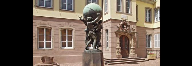
Visitors enter the museum courtyard via a covered passageway. At the centre of this courtyard lies Bartholdi's bronze group statue, 'Les Grand Soutiens du Monde' (The World's Great Bases) representing Justice, Labour and the Motherland, which was exhibited at the 'Salon de Paris' in 1902. The main entrance to the museum is located to the right of the courtyard. It is a Renaissance doorway, brought to Colmar and installed in the second half of the 19th century by Bartholdi during the refurbishment of the family home with three overhanging sculptures in moulded concrete, Bartholdi's work, representing two heraldic lions flanking a human-like ram. Inside, the museum occupies 3 stories and a total surface area of 700 m². On the ground floor, the Hall of Artworks from Alsace and Colmar unites Bartholdi's work linked to his native region - 'La Borne Frontière' (the border milestone), 'la Malédiction de l'Alsace' (the curse of Alsace) or 'la Suisse secourant les douleurs de Strasbourg' (Switzerland aiding the suffering of Alsace) - as well as models and certain original elements of monuments erected in Colmar (Monument Rapp, Le Petit Vigneron, Les Grands Soutiens du Monde, etc.).
In the left wing on the first floor are Bartholdi's living quarters, which include his office, a music room and notably the very elegant dining room with a coffered ceiling encrusted with China. It is also in this room that the visitor will find a series of portraits of Bartholdi's ancestors from between the 17th and 19th centuries. On the central table and the sideboards are china dishes and ceramics signed by Théodore Deck, the director of the Sèvres china factory and Bartholdi's friend. Finally, the Napoleon III room contains a large portrait of the sculptor's mother Charlotte Bartholdi, painted in 1855 by Ary Scheffer, as well as portraits of Auguste Bartholdi and his wife, painted by Jean Benner an artist from nearby Mulhouse.
The right wing of the house leads into the library, then on to the rooms containing Orientalist artworks allotted to the works produced by the artist during and after his first trip to the Orient (Egypt-Yemen, 1855-1856). On this floor, the visitor will also find the impressive hall of models containing models of most of the statues and public monuments created by Bartholdi for French towns, with the exception of Colmar: Vauban (Avallon, 1873), Gribeauval (Paris, courtyard of the Hôtel des Invalides, 1876), the Lion of Belfort (1880), Rouget de Lisle (Lons-le-Saunier, 1882), Diderot (Langres, 1884), Gambetta (Sèvres, 1892), Monumental Fountain (Lyon, place des Terreaux, 1892). It also contains numerous rough preparatory models in terracotta and a series of bronze models: The Lion of Belfort, the Statuette Equestre de Vercingétorix, Les Sept Souabes (1855), Le Génie Dans les Griffes de la Misère (1859), Statuette of Vauban (1870) and the Statuette du Fondeur Thiébaut (1899).
Finally, the second floor is totally devoted to American artworks. The visitor will discover original models, prints and old photographs related to the fountain in the Botanic Garden (New York), the low reliefs of Battle Street Church (Boston), the monument to La Fayette and Washington (New York and Paris), not forgetting, of course 'La Liberté Eclairant le Monde' (New York), better known as the Statue of Liberty. In stark contrast to certain bland museums built nowadays, the museum dedicated to Bartholdi has a soul. Through the works on display, it plunges the visitor into 19th century history, at the heart of the Third Republic born of the Franco-Prussian war of 1870-1871.
Guided visits for groups in French, German, English, Italian, and Japanese on appointment through the Tourist Office Museum opening hours: Daily except Tuesday from 10:00 to midday and from 14:00 to 18:00 Closed in January and February and on 1 May, 11 November and 25 December Admissions:(ticket desk closes 1 hour before museum closing time) Individuals Adults: €4.10 Students: €2.50 Groups (10 persons +) Adults: €2.60 Students: €1.50 Free for children under 12 years old Contacts: Musée Municipal Bartholdi 30, rue des Marchands 68000 Colmar, France Tel.: +33 (0)3 89 41 90 60 Fax: +33 (0)3 89 23 50 77 E-mail: musees@ville-colmar.com

> Return to results

Practical information

Address

30 rue des Marchands 68000
Colmar
tél. : 03 89 41 90 60Fax :03 89 23 50 77

Prices

Tarifs individuels Adultes : 4 € Étudiants : 2,50 € Tarifs groupes (à partir de 10 personnes) Adultes : 2,60 € Étudiants : 1,50 € Gratuité pour les enfants de moins de 12 ans

Weekly opening hours

Ouvert tous les jours, sauf le mardi de 10 à 12 heures et de 14 à 18 heures

Fermetures annuelles

Fermé en janvier et février ainsi que les 1 mai, 11 novembre et le 25 décembre

Fort Boyard

Vue générale du fort (façade Est). Source : ©Fabien1309 - License Creative Commons - Libre de droit

Halfway between the island of Oléron and the island of Aix to which it is attached, the impressive silhouette of Fort Boyard stands proudly like a "stone warship" perched on the fortified reefs.

Halfway between the island of Oléron and the island of Aix to which it is attached, the impressive silhouette of Fort Boyard stands proudly like a "stone warship" perched on the fortified reefs. Shortly after the construction of the naval shipyard at Rochefort, the location of the current fort was the subject of a study that concluded that it was impossible to build a defensive structure on the sand bank that ran alongside Boyard.

Sébastien Le Prestre de Vauban, who would later become the General Commissioner for the Kingdom's fortifications, wrote the following to King Louis XIV: "Sire, it would be easier to grasp the moon between your teeth than to undertake such work on this site". Failing to materialise for technical reasons, the idea of building a defensive fort was dropped. Fouras, la Rochelle and the islands of Aix and Oléron were strategic positions that controlled access to the Charente until the beginning of the 19th Century. However, the protection of Rochefort and its channel by all these sites proved ineffective, as they were too far away from the corridor taken by the ships leaving the naval shipyard.
Robbed of its strategic importance, it became a target for German troops carried out target practice against its walls during the Second World War. The start of its film career dates back to 1966, when its upper level was used as the setting for the final scene in Robert Enrico's film "les aventuriers" ("The Last Adventurer") with Lino Ventura and Alain Delon. In 1980, the fort was bought by an audiovisual production company and then donated to the Charente-Maritime General Council, resulting in it being used for the purpose for which it is now world famous. No longer open to the public due to its new television vocation, its surroundings can still be seen from one of the many pleasure boats offering tourists a close up view.
Its defensive purpose reduced to nothing because of advances in artillery, it was used as a detention centre from 1870 onwards: a military prison for Prussian and Austrian soldiers and then a place of detention for hundreds of communards, before being abandoned after 1913.
 

Mairie of the island of Aix

Rue Gourgaud 17123 Ile d'Aix

Tel. + 33 (0) 5 46 84 66 09

Fax + 33 (0) 5 46 84 65 79

E-mail: mairie@iledaix.fr


> Return to results

Practical information

Address

17123
Ile d 'Aix
05 46 84 66 09

Weekly opening hours

Ne se visite pas

The Fort de la Rade

Ile d'Aix - Fort de la Rade. Source : http://www.napoleoncities.eu

Le fort de la Rade owes its current appearance and name to work carried out in Napoleonic times.

Since the creation of the naval shipyard at Rochefort, the pointe Sainte-Catherine, opposite Fort Boyard on the southern part of the island, has been the home of the first fortifications on the Ile d'Aix. Drawing its inspiration from plans devised by Vauban, construction of the Fort de la Sommité began in 1699 and was completed in 1703. Accessed via a drawbridge and surrounded by moats, the fort is then flanked by five bastions, of which traces remain visible today at low spring tides. In September 1757, during the Seven Year War, the English fleet commanded by Admiral Hawke arrived in the harbour of the Ile d'Aix and completely destroyed this first fort. In 1779, Montalembert, along with his deputy Choderlos de Laclos, undertook the construction on the same site of a wooden fort, which proved temporary as it was destroyed in 1783 without ever seeing any action.

The Fort de la Rade owes its current appearance and name to work carried out in Napoleonic times. Equipped with an impressive central building designed to accommodate its artillery pieces, the fort has long ramparts that allow a full tour of the fort whilst providing an unobstructed view over the islands of Madame, Oléron and Ré, the two lighthouses on the Ile d'Aix and the famous Fort Boyard. Various refurbishment work was carried out during the second half of the 19th century, including the concrete shelters dating from 1890.
Since 1986 tourist facilities have been set up in the Fort de la Rade, which is open all year round and free to visit.
Le fort de la Rade Mairie de l'île d'Aix Rue Gourgaud 17123 Ile d'Aix Tel. + 33 (0)5 46 84 66 09 Fax + 33 (0)5 46 84 65 79 E-mail:mairie@iledaix.fr

> Return to results

Practical information

Address

17123
Ile d'Aix
05 46 84 66 09

Weekly opening hours

Accès libre

Fort Liédot

Fort Liédot. Panoramique façade sud-ouest. Source : © Llann Wé² - License Creative Commons - Libre de droit

Fort Liédot

In 1808, during an inspection of the site works at Fort Boyard, Napoleon decided to complete the defensive system of Rochefort harbour by having a fort built on the highest point at Aix, at the eastern end of the island. Square in shape, this bastioned fort measuring over 90 metres wide was built in stone and was fully casemated. Four galleries lead off in different directions from the interior courtyard, serving the casemates located beneath the bastions, with each curtain wall containing four vaulted casemates for accommodating the troops. Protected by a thick earth embankment and covered with a grass slope, the fort was surmounted by an impressive circular walkway.

Square in shape, this bastioned fort measuring over 90 metres wide was built in stone and was fully casemated. Four galleries lead off in different directions from the interior courtyard serving the casemates located beneath the bastions, with each curtain wall containing four vaulted casemates for accommodating the troops. Protected by a thick earth embankment and covered with a grass slope, the fort was surmounted by an impressive circular walkway. Between the 12th and 15th of July 1815, Napoleon spent his last days on French soil at Fort Liédot, before giving himself up to the British and leaving for Saint Helena. During the Crimean War led by Napoleon III, about a thousand defeated Russian soldiers were detained inside the fort, which was later abandoned, as the use of rifled artillery considerably reduced the resistance capacity of stone fortifications. That is why firing tests were carried out on Fort Liédot from 1863: although the casemates were able to withstand it, all the walls exposed to artillery volleys were destroyed. Despite this partial destruction, the fort's role as a prison was not weakened and several hundred communards were imprisoned within its walls from 1871 to 1872 as they awaited their departure for New Caledonia.
It was used as a detention centre for German prisoners during the First World War, before fulfilling a completely different role between the wars, when it was temporarily turned into a pleasant holiday resort for summer camps. Between 1959 and 1961, Fort Liédot held its last prisoners to date: the man who was to become President of Algeria, Ahmed Ben Bella, and several of his comrades of the FLN. In 1989, the Ministry of Defence donated Fort Liédot to the coastal conservatory, with the fort now being managed by the island of Aix local authority. There are guided tours in July and August and by appointment from September to June. The fort was restored at the end of the 19th Century, most notably for the installation of guns from the naval infantry on its terraces.
Fort Liédot Mairie of l'île d'Aix Rue Gourgaud 17123 Ile d'Aix Tel. +33 (0) 5 46 84 66 09 Fax + 33 (0) 5 46 84 65 79 E-mail:mairie@iledaix.fr

> Return to results

Practical information

Address

17123
Ile d'Aix
05 46 84 66 09

Weekly opening hours

Visites guidées tous les jours en juillet et août, et sur réservation de septembre à juin.