Newsletter

Balaguier Fort

Le fort Balaguier. Source : ©Julien MAUCERI. http://www.ctoulon.com/

This 17th century fort was built to protect the entrance to Toulon harbour.

In the 16th century, Toulon harbour was surrounded by a system of defences designed primarily to protect access to it by sea and then - as the range of artillery increased - by land. After 1524, the commercial port of Toulon was protected by the "Big Tower" or Royal Tower. In 1634, Richelieu convinced Louis XIII to build another tower on Balaguier Point, opposite the Royal Tower, thus enabling the harbour entrance to be effectively locked. The aim was still to protect Toulon harbour, but more particularly, a small arsenal founded under Henri IV and which Richelieu, First Minister of the Navy, believed would grow in size. In 1679, Vauban was appointed to the Board for Fortifications.

The arsenal left the galley base at Marseilles and moved to the heart of the new dock. As part of the new design for fortifications, the canon tower of Balaguier was equipped with the ramparts, walls, accommodation and powder stores which give the fort its current appearance. In late August 1793, when the English entered Toulon, Balaguier became the target for the observers. Initially a refuge for sailors refusing to accept the English occupation, Balaguier went on to be occupied by coalition troops. The young republican artillery commander, Napoleon Bonaparte, understood the strategic importance of the location of the second element of the harbour protection. After two months of inconclusive fighting, his plan was finally accepted and, leading his troops into the attack by land, he took Balaguier Fort on 17th December 1793. The republican canons were then turned on the English fleet, which withdrew. After the Fachoda crisis, Balaguier Fort was rearmed one last time. Then, no longer of use, it was rented privately between the wars. Occupied by the Germans in 1942, it was liberated in 1944. After restoration, it has been a museum of maritime and local history since 1970.
Since 17 March 1975 it has been on the inventory of additional historical monuments. Balaguier Tower, or the "Little Tower" as opposed to the Royal or "Big Tower" was designed according to Richelieu's plans. The structure originally included a 19.5 m diameter canon tower. The basement contained a water cistern and magazines for powder and provisions. Access to the outside was via a drawbridge. This level consists of a vaulted room providing quarters for around forty men. The upper section of the tower was equipped with a canon platform protecting the harbour entrance from eight embrasures and a covered walkway whose parapet was broken by firing positions for close defence. On either side of the tower itself, batteries were built to provide grazing fire from parapets equipped with embrasures.
This building has been entrusted to the Ministry of Defence. France's Defence and Culture ministries signed an agreement to restore it, on 17 September 2005.
Ministère de la défense(Ministry of Defence) Secrétariat Général pour l'Administration (General Bureau for Administration) Direction de la Mémoire, du Patrimoine et des Archives (Remembrance, Heritage and Archives Department) 14 rue Saint-Dominique 00450 Armées E-mail: dmpa-sdace-bacm@sga.defense.gouv.fr

> Return to results

Practical information

Address

Esplanade Jacques Lebon 83500
La Seyne-sur-Mer

Prices

Adultes : 3 euros. Tarif réduit, étudiants, chômeurs, Rmistes et groupe (plus de 8 personnes) : 2 euros. Gratuit pour les enfants de moins de 5 ans.

Weekly opening hours

Du 1er au 18 septembre et du 1er octobre au 30 juin, du mardi au dimanche de 9h à 12h et de 14h à 18h Du 1er juillet au 31 août, du mardi au dimanche de 10h à 12h et de 15h à 19h

Fermetures annuelles

Du 19 au 30 septembre

Chapel of Saint Joan of France in Bourges

Plaque. © C. Caudron - SGA/DMPA

The monastery’s churchyard was acquired by the city of Bourges in 1834 and was transferred to the State in 1857. It was then assigned to the army.


The Chapel of Saint Joan was part of the Convent of the Annunciation founded in 1503 by Joan of France, daughter of Louis XI.

The monastery’s churchyard was acquired by the city of Bourges in 1834 and was transferred to the State in 1857. It was then assigned to the army. The Chapel of Saint Joan was part of the Convent of the Annunciation founded in 1503 by Joan of France (1464-1505), daughter of Louis XI and Charlotte de Savoie, also known as Joan of Valois, who was canonised by Pope Pius XII in 1950.

The choirs

The inside was separated into two nearly equal parts by a dividing wall.
The first part, to the west and lit by small windows, had the nun’s choir on the first floor, forming a tribune. It could be reached by a winding stairway that still exists today and which also provided access to the convent buildings.
A second choir is on the ground floor for the Brothers, whom Saint Joan dreamt of having join the Sisters of the Annunciation for the convent’s religious services.

The second part of the chapel was made up of the area reserved to the faithful and the sanctuary whose shape follows that of a regular semi-hexagon.


The attic space

The wooden vault, currently hidden by a ceiling, followed the curve of the frame in the form of a pointed barrel vault.

The girder trusses were visible; the ends of their tie beams sculpted with phantasmagorical heads, some of which can still be seen, swallowing the beams. All of this, which can be admired in the chapel’s attic space, was painted in colours that have been fairly well preserved. The panelling is painted a greyish white and the joint covers in blue, red and white, the colours of the Sisters of the Annunciation’s habits.

The pinnacles

The main entrance door with its triangular arch is crowned with two pinnacles and an ogee arch with slopes decorated with thistle leaves. Around the central finial, the initials of the Virgin Mary’s ten virtues are sculpted in capital Gothic letters. In the 17th century, the tips of the two pinnacles were cut off to install fire-pot finials and the central finial of the ogee arch was eliminated to make a niche where a statue of the Virgin Mary was probably placed.


The monastery churchyard

In the 18th century, the Monastery of the Annunciation’s churchyard was cut off to build the current Avenue du 95ème-de-Ligne and the entrance to the convent was equipped with a large, round-arched portal. In 1793, the Sisters of the Annunciation were dispersed and their belongings sold. The monastery churchyard was acquired by the city of Bourges in 1834 and was transferred to the State in 1857. It was assigned to the army.


Refurbishment of the chapel

The refurbishment work on the chapel undertaken by the Engineering Department enabled it, in May 1961, to once again be used for religious services and for the military chaplain of Bourges. The departmental military delegate, the garrison office and the CIRAT (Army Information and Recruitment Centre) are located in the building.


Lignières Parish Priest

Rue Jeanne de France 18160 Lignières

Téléphone : 02 48 60 00 61

Télécopie : 02 48 60 18 92


Ministry of Defence

Secrétariat Général pour l'Administration Direction de la Mémoire, du Patrimoine et des Archives

14 rue Saint-Dominique 00450 Armées

E-mail : dmpa-sdace-bacm@sga.defense.gouv.fr


> Return to results

Practical information

Address

6 avenue du 95ème de Ligne 18000
Bourges
Fax : 05 46 87 53 27

Weekly opening hours

Dimanche: 14h-18h

Sénarmont indoor arena in Fontainebleau

Built in 1807 in the Carrousel Quarter, a Fontainebleau Chateau outbuilding, under Napoleon I.
This arena was built in 1807 in the Carrousel Quarter, a Fontainebleau Chateau outbuilding, under Napoleon I. Its extraordinary wooden framework is one of the features that have earned it historical-monument status. Quartier du Carrousel was a Fontainebleau Chateau outhouse that was handed over to the armed forces in 1871. The history Emperor Napoleon I had had this arena and its remarkable single-vault wooden frame built in 1807. It was listed (along with the area around it) as an historical monument in 1913 and 1930, and named after General Sénarmont. The stables surrounding the Cour du Carrousel or Cour Carrée were also built around about that time. The latter is much older because again, the National Archives, the trace of its construction by Louis XVI in 1784 and 1785. It was used for the Petite Ecurie du Roi. 1815 to 1870 These buildings housed military staff serving under French kings and Emperor Napoleon III until 1870. 1871 to 1940 The Quartier du Carrousel was then handed over to the Ecole d'Artillerie (Artillery School) where young officers such as Ferdinand Foch, who went on to become a Marshal of France and of the United Kingdom, trained in the art of horse riding. That was when the arena was built and named Manège Drouot, after the Emperor's aide-de-camp and Imperial Guard General Major. World War II to the present day The buildings were abandoned for a short spell during World War II, but were then refurbished to house the École Nationale d'Equitation (National Horse Riding School) that a group of former members of the disbanded Cadre Noir (an elite cavalry corps) founded. The prestigious Military Equestrian Instructor corps was established there in 1945. The Cadre Noir corps joined the École d'Application de l'Arme Blindée et de la Cavalerie (Armour and Cavalry School) in Saumur in 1946. The military equestrian games were established then too. The centre was in Quartier du Carrousel. This centre briefly came under the École Interarmées des Sports (Army Sports School) in Fontainebleau but became independent again and was renamed Centre Sportif d'Equitation Militaire on 1 April 1973. As an army cavalry corps, it came under the Commandement des Ecoles de l'Armée de Terre (Army School Command) on 1 September 1976. That authority became the Commandement des Organismes de Formation de l'Armée de Terre (Army Training Unit Command) in 1993. The disbanded 8th Régiment de Dragons flag - and that regiment's traditions - were entrusted to its care in 1977 -and its traditions. Today, the buildings house the Centre Sportif d'Equitation Militaire (Military Equestrian Sports Centre) which oversees military equestrian sports across France. The French ministries of Culture and Defence have signed an agreement to develop and promote this centre.
Architecture This historical monument's highlight is no doubt its amazing single-vault Philibert-Delorme wooden frame (named thus after the architect who designed the first such frame in 1551). The arena is 66 metres long and 20 metres wide. The chestnut-tree frame sits on a cornice holding the string pieces and hoop bases. A second string piece sits on the walls and holds the cornice brackets and the top chords. The top chords and hoops converge on a umber of pegs (as it were) at the top. These components are all similar. They each comprise two 25-mm thick and 30-cm wide fir boards, overlap, and wrought-iron nails hold them in place. The 0.05 x 0.15 stanchions converge on the cornice hoops, two iron bands clamp them to the wall, and ridge ribs hold them in place. Splines on either side secure them to the ridge ribs. They are assembled in an alternating pattern: the same peg fastens each set of face-to-face ridge ribs. A few figures will provide a clearer impression of this building's daunting size: each truss (there are about one hundred) holds 104 ridge ribs and 312 mortises. Meaning there are about 31,000 mortises on the 100 trusses.
This building has been entrusted to the Ministry of Defence. France's Defence and Culture ministries signed an agreement to restore it, on 17 September 2005. Click here to see the list of other buildings...
Fontainebleau Chateau 77300 Fontainebleau Tél. : 01 60 71 50 70 Fax : 01 60 71 50 71 Mail : resa.chateau-de-fontainebleau@culture.fr
> Return to results

Practical information

Address

boulevard magenta 77300
Fontainebleau
Tél. : 01 60 71 50 70 Fax : 01 60 71 50 71

Weekly opening hours

Se renseigner pour l'accessibilité au site

Troyon Fort

Le fort de Troyon. Source : http://tcqlmayotte.canalblog.com

This fort is part of the defence line between Nancy and Verdun that General Séré de Rivières devised...

Troyon fort was built between 1878 and 1879, as part of the defence line between Nancy and Verdun that General Séré de Rivières had devised. This "central massif" or "low battery" fort stands between Troyon and Lacroix sur Meuse, and had two advantages: it was neither armour-clad nor concrete. Dimensions: 320 m wide, 270 m long, spanning 5 ha Garrison: 800 men (450 in 1914) Weapons: Trench protection: six canons, twelve breeches Six Hotchkiss 40-mm revolver canons Shooting platforms: twelve 90-mm canons (three batteries x four canons) Four 120L canons Indirect fire: Two 15-cm bronze "Louis-Philippe" mortars This fort also had two 1907 "Saint Etienne" machine-gun sections and three periscope observation posts. It did not have an armoured dome (as Loncin had), but it had 18 open-air double (two-gun) platforms.

German forces tried to surround Verdun very early on in the Great War. They moved 20 km into French terrain, from Bois le Prêtre to Eparges through Saint Mihiel, in September 1914. They held that pocket - Saillant de Saint Mihiel - despite France's deadly yet persistent attempts to take it, until American troops freed it in September 1918. Troyon Fort played a pivotal role in the September 1914 fighting that led to the Saillant de Saint-Mihiel.
The bombing started on 8 September 1914, and the troops there were ordered to ward off assaults for at least 48 hours - lest German troops surround Verdun (Troyon is south of Verdun). Major Neuhoff, a 10th Division German Army Staff Officer, ordered the fort's troops to surrender on 9 September 1914. But 166th Infantry Regiment Captain Heym, the man in charge of the fort, dismissed him. German forces pounded the fort with shell fire shortly afterwards. The pummelling ceased on 10 September 1914. The fort had held on and its heroic resistance changed the course of the war. Had it fallen, German forces would have crossed the Meuse river and enveloped Verdun.
Association Ceux de Troyon Association "Ceux de Troyon" BP 32 55300 Saint-Mihiel Tél. : 06.83.07.32.12 Fax : 03.29.84.35.99 Open 1.30 pm to 6.00 pm Saturdays, Sundays and bank holidays. Getting there: you will find signs to Fort de Troyon leaving Troyon and Lacroix Group visits (for 10 or more people) poss. weekdays by appointment. Comité Départemental du Tourisme (Departmental Tourist Authority) Tel: +33 (0) 329 45 78 40 Conseil Général de la Meuse (Meuse Department General Council) Hôtel du Département Place Pierre-François Gossin 55012 Bar-le-Duc cedex Tel: +33 (0) 329 45 77 55

> Return to results

Practical information

Address

55300
Troyon

Weekly opening hours

Ouvert le samedi, le dimanche et les jours fériés, de 13h30 à 18h00

The Butte de Vauquois

Gros plan sur le monument de La Butte de Vauquois. Source : http://cdelmars.pagesperso-orange.fr/

Straddling the Meuse, the Marne and the Ardennes, Argonne was at the heart of the Great War's battles

The Argonne region was at the heart of the Great War's battles. Straddling the Meuse, the Marne and the Ardennes, this massif felt the echo of battles at Marne and Verdun, witnessed violent confrontations on its own soil, and served as a rearguard base for many soldiers. The Vaux-Marie, the Butte de Vauquois, the Haute-Chevauchée...several Argonne names are famous, for less than felicitious reasons... The General Staff felt that the butte de Vauquois, which dominates the entire eastern region of the Argonne, was an excellent observatory and a key strategic site. On 24 September 1914, the Germans took the butte and transformed it into a veritable fortress. On 4 March 1915, after several unsuccessful attempts, the French began to make a comeback. The fight for space had begun. The soldiers went underground to dig several kilometres of tunnels and combat gullies so that they could infiltrate the enemy camp, set off tonnes of explosives, and decimate enemy numbers as much as possible, The Butte de Vauquois became something akin to a termite colony, made up of multi-level underground construction (more than 17km of wells, tunnels and gullies). It served as a major site in the Mine War (519 reported explosions, of which 199 are German and 320 French), and was liberated by the Americans on 26 September 1918. As a still-intact Great War site, the Butte de Vauquois is a classified Historic Monument.

Association des Amis de Vauquois 1, rue d'Orléans - 55270 VAUQUOIS Tel.: 0033 (0)3 29 80 73 15 Answering machine. We will return your call as soon as possible. E-mail: amis.vauquois@wanadoo.fr Daily free, self-guided visits of the above-ground site (follow the arrows). Guided tours of the German and French underground installations by Association guides: [list]the first Sunday of the month at 9.30am [list]1 and 8 May (from 10am to 6pm) annually [list]September on national "journées du patrimoine" annually [list]on appointment for groups (minimum 10 people) A free map of all the 14-18 sites open to the public is available at all the sites and at Meuse tourist information offices.

> Return to results

Practical information

Address

55270
Vauquois
Tél. : 03 29 80 73 15

Weekly opening hours

Visites guidées des installations de surface et souterraines: le 1er dimanche de chaque mois de 9h30, les 1er et 8 mai de chaque année (de 10h à 18h), en septembre, chaque année lors des journées du patrimoine et sur rendez-vous pour les groupes (+ de 10

Saint-Mihiel Salient

Tranchée. ©Office de Tourisme de Saint-Mihiel

On 7th September, two German divisions gather near Saint-Mihiel and march on the town...

The battles of the Twentieth Century changed the shape of the world, but how many tears... ravaged countries... bereaved, mourning, defeated, sacrificed, seriously damaged nations.... Some of the Great War's Battles took place in la Meuse between 1914 and 1918. Our "sad souls" here are Verdun, the Argonne, Les Éparges, and the Saillant de St Mihiel... taking the time to discover them and understand them means that the memory of all the men that died here will live on.

As the years pass, the duty to remember becomes a duty to tell the story of what happened. The Germans had wanted to take the fortified town of Verdun from the very beginning of the war. So in September 1914 they advance more than 20km into French territory, moving from Bois-le-Prêtre to Les Eparges, via St Mihiel. This corner of France (the St Mihiel Salient) remains under German control until the Americans come in 1918, despite several bloody French effensives in the intermittent years. After September 1914, the main French goal will be to try to get back the terrain taken by the Germans, and reduce the surface area of the Salient. The Bois d'Ailly and the Tranchée de la Soif (Trench of Thirst) bear witness to the suffering of Commander André's men, forced to surrender to the Germans in May 1915 because they had neither food nor water. Marbotte Church became a makeshift hospital, providing shelter for so many injured and dying soldiers that its floor was stained red with blood. The Bois Brûlé (The Burned Forest) is one of the places that best represents battles above ground: it also reveals the proximity of the French and German troops. It is also here that Sergeant Péricard commanded, "Debout les morts!" ("Dead men, Rise!") on 8th April 1915. In the Bavarois and Roffignac trenches, you can follow the soldiers' footsteps, climb the firing banks, and look through the openings. This is no ordinary place: it's a battlefield, and deserves your respect.
Association Nationale Le Saillant de St Mihiel 71, rue du Dr Vuillaume 55300 St Mihiel Tél. : 03 29 90 90 07 Regional Tourist Board Tel: 00 33 (0)3 29 45 78 40 b]Conseil Général de la Meuse[/b] Hôtel du Département Place Pierre-François Gossin 55012 Bar-le-Duc cedex Tel: 00 33 (0)3 29 45 77 55 Contact Office de Tourisme de Saint-Mihiel Rue du Palais de Justice 55300 Saint-Mihiel Tel./Fax : 00 33 (0)3 29 89 06 47 Email: otsi.saint-mihiel@wanadoo.fr Information Four memorial platforms indicate remnants from the Great War. The boards and milestones located in car parks and in the forest (30 min. per platform, follow the arrows) also provide you with information. You can visit at any time, and entry is free. Guided Tours upon reservation. A free map of all the 14-18 sites open to the public is available at all the sites and at Meuse tourist information offices.

> Return to results

Practical information

Address

55300
Saint-Mihiel

Weekly opening hours

Accessible toute l'année

Froideterre Fortification

Ouvrage de Froideterre. Photo ECPAD

Forming part of the entrenched camp of Verdun, Froideterre cordons off the northern edge of the town between the Meuse valley and the hills on the right banks.

Froideterre Platform

Part of the entrenched camp of Verdun, Froideterre cordonned of the northern edge of the town between the Meuse valley and the hills on the right banks. It was designed as a centre for resistance, and is a great example of the variety of features and levels possible within a permanent fortification. The traces that remain also show how important these were during the crucial phases of the summer of 1916. Froideterre fortification , on the Meuse-Douaumont ridge, was key to the defence system. Surrounded by a stream, and boasting a concrete bunker and turrets or casemates for its artillery, it could flank the neighbouring fortifications at Charny and Thiaumont, support the units, and ensure its own defence. Its efficacy was enhanced by features that helped the infantry on guard, positioned at intervals along the wall. Concrete parapets (entrenchments X and Y) both sheltered marksmen as they stood and provided gun cover for the hill's exteriors flanks. Set slightly back from the military ridge, battle shelters hidden in the folds of the hillside were designed to protect the section's infantry soldiers from artillery fire. The concrete arches of these refuges contained arms, and played a vital role in battle. Elsewhere, logistical systems were hidden in the flanks of the ravines, containing food supplies. Like all places likely to come under shell attack, these shelters and storehouses became command posts or makeshift emergency rooms during battle, and served as precarious shelters for the units in charge of defending the ridge. The ventilation chimneys of the Quatre Cheminées cave shelter, which was planned to lodge reserve troops and supplies, were buried under 8m of rock. Buried in the same hillside, a little storeroom hid the masonry at its entranceway. It, along with the section's magazines, ensured that ammunition was supplied to the artillery batteries (like MF3) located far from the town. A network of stone pathways and narrow gauge railways linked this section, like all those on the belt, to the fortified town to allow artillery cannons to be moved, ammunition to be brought from the arsenal, and foodstuffs, supplies and accessories to be transported. The unprecedented bombing that accompanied the offensives at Verdun not only destroyed the fortifications' superstructure and access points, but also repeatedly killed communication with the outside world. The narrow liaison tunnels, filled with debris and dead bodies, had to be used instead of the path. Located opposite the Quatre Cheminées shelter, the ravin des Vignes, became a new artery for a front that kept gobbling up men and supplies. It was crisscrossed with these precarious alleys, which the artillery took for targets during the changing of the guard. To maintain the fragile link between the front lines and the shelters, they needed liaison officers, "runners" thrown into the fray of bombing and the barrage of gunfire - few of them managed to make it alive. In the end, they had to resort to flares to inform the artillery and ask them for help, hoping that in the midst of all the gunfire, their shot would spare their own men.

> Return to results

Practical information

Address

55100
Fleury-devant-Douaumont

Weekly opening hours

Accessible toute l'année

Fort Souville

Le fort de Souville. Source : http://ecolenotredameduguildo.blogspot.fr/

Captain Gustave de la Taille, who built this fort, named it Souville, a Loiret village.

Last Judgement at Verdun

After their major attacks on 21 February, 10 April and 25 May 1916, the Germans occupied the elevated côte du Poivre and the côte des Chambrettes on the right bank of the Meuse, as well as Fort Douaumont, a particularly important vantage point which was to become an essential part of the enemy's logistical plan. On 7 June, the enemy got as far as the defending ranks on the Fort Vaux, and those on the front lines reached the Eastern slopes of the high ridge punctuated by Thiaumont, the ruins of Fleury village and the Fort Souville. If the Germans managed ito take this ridge, their artillery would be able to fire straight at Verdun and the bridges over the Meuse from less than 5000m away, thus putting the French in grave danger. If, on the other hand, the ridge remained French, then not only would it be possible to defend the right bank, as Commander in Chief Joffre ordered, but it might also be possible to counter-attack and take back the forts at Vaux and Douaumont.

While the obdurate enemy charged to take the Thiaumont-Fleury-Souville ridge, the period from June to September constituted "the last judgement at Verdun," a horrible drama in which the epic, partially destroyed (1) Fort of Souville saved the day no fewer than three times. On 23 June, when the violent German offensive began, Souville dominated and flanked the entire combat zone. The French artillery used it as a look-out post from which to barrage the blocked enemy infantry with projectiles. On 11 July at dawn, the Germans charged at Souville. They did the same on the 12th, and got as far as the fort. Thanks to the artillery and the counter-attacks of the 7th Regiment and the 25th Batallion of Light Infantrymen, the few enemy soldiers that actually reached the fort were imprisoned. Souville escaped German clutches. The parallel ridges of Froideterre and Souville - Thiaumont and Froideterre on the one hand, the Forts of Vaux and Souville on the other - all played a major role in directing the enemy attack. Once Thiaumont was taken, the enemy effort ground to a halt on Froideterre. Fort Vaux fell to the Germans on 7 June, but on 11 and 12 July, Souville came to the rescue once again. Once Fleury was taken, the Germans rushed to take advantage of the ravines at la Poudrière, but because Froideterre and Souville were still in the hands of the French, it was impossible for them to capitalize on their success: they were threatened on all sides. This month-long battle for Souville-Fleury-Thiaumont revealed the vital role of permanent fortifications in the Battle of Verdun. And it was thanks to the combination of the extraordinary resilience of Verdun's "poilu" soldiers and the energy of the high command that this battle was won and Verdun saved. (1) From 21 June on, it was subject to daily attacks that gravely crippled its defences.


Souville's fortified massif A complete defence system

Captain Gustave de la Taille, the ingenious officer who built this fort, gave it the name of the Loiret village -- Souville -- in which his ancestor, Bertrand de la Taille, groom to the Lord of Souville, had been laid to rest in 1319. In 1916, this massif consisted of: Fort Souville: situated at 388m above sea level (at precisely the same altitude as the Fort Douaumont), and built between 1875 and 1879 from limestone covered with 3-5m of earth. The ditches that surrounded it featured built-in scarps and counterscarps, flanked by caponniers armed with revolver cannons and 12 tonne breechblock canons. In 1889, the whole thing was wrapped in barbed wire 30m thick. It was one of the Séré des Rivières belt's "first generation" forts, like those at Belleville, Saint Michel and Tavannes. In 1888, the gunpowder magazine was reinforced with 2.5m of concrete and a 1m thick layer of sand. Connecting passageways were built, as well as six 18m by 5m shelters, each protected by an 8m thick layer of blocks made from rock, marl, and loose stones. The fort housed the district's telephone exchange, consisting of two underground lead circuits that connected it to Fort Douaumont and the fortification at Thiaumont, plus two overhead cables linking other forts and the Verdun citadel exchange. Before conflict began, there were plans to establish a communication system for clear days, using lights, with the fortified town of Longwy, more than 35km away as the crow flies
An organic garrison: 2 infantry troops, 2 artillery sections, reinforcement gun crews for sixteen machine guns and various service personnel indispensable to the life of the fort. In peacetime, the fort was accessed via a gravel path -- named "le chemin de Souville," it is still in use today. It leads to the drawbridge of the wartime entrance, an underground shelter with room for 300 seated men. Serpentine back alleys lead from this introductory path, winding out of the path of gunfire. A Bussière system eclipse gun turret for two 155 mm canons, built in 1890-1891 150 metres west of the fort. Around 600 shells were fired from this turret between 24 February and 6 March 1916, but when one of its two tubes exploded on 10 April of the same year, it was decommissioned. It was March 1917 before it was back in action, now just a single tube powered by a twelve horsepower electric motor instead of the original steam one. From this time on, the turret was linked to the fort and the emergency exit via a 140m long bombproof alley. A De Bange 155 terraced fortress battery built in 1882, with built-in recessed niches for weaponry half a metre thick. The niches faced West, and were situated about 100m from the Bussière turret. Some remains of the battery can still be seen today and are indicated on the massif's discovery trail, which begins at the memorial.
Criss-crossing alleys form a communication network that can still be seen all over the fortification -- it ensures that relief soldiers can arrive, the injured can be taken to safety, food supplies, arms and equipment can arrive. The network begins both at the Marceau barracks (one of the entrances to the battlefield) towards Souville and at the village of Fleury, then heads for the river and the village of Vaux (the Carrières alley), the Vaux Régnier, Fumin woods and Fort Vaux. It means that even without underground passageways, there are internal connections at the heart of the massif between the fort, the 155mm gun turret and the fortress battery. In May and June 1916, it comes under attack from 380 mm (750 kg) and 420 mm (1 000 kg) shells, which destroy all the stone spaces, the caponniers, the barbed wire fence, the five 90mm carriage cannons and two 15mm mortars. Afterwards, the defenders and lookouts have to occupy the holes made by the shells, and are totally unprotected. After the Battle of Verdun is over, major work begins to restore the fortified massif at Souville: wells yielding 1 500 litres a day, underground shelters linked by tunnels, lined with 10 to 15 metres of protective compacted marl, a 140m tunnel linking the fort to the renovated 155mm gun turret, with a 12 horsepower electric motor replacing the previous slow and complicated steam system, an emergency exit for the 155mm gun turret with a Digoin concrete observation post. It is surrounded by a barbed wire fence between 20 and 30 m thick. In 1917, three Pamart casemates weighing 2.5 tonnes with 14cm shields are installed on the fort's slopes for its imminent defence. These fixed gun turrets cannot be withdrawn, and each one features two carriage-mounted machine guns. Because of their design, they have a 160 degree range, less than that of the 1900 model machine gun turret (360 degrees). However, their more modest dimensions and weight mean that they are easier to build and to install during a campaign on the particularly troubled terrain of Verdun. They are also more reliable than the eclipse gun turret, which often gets blocked by rubble when shells explode.


1917: Making the forts stronger


Developed during the war by Commander Pamart serving at Fort Génicourt, these machine gun casemates were also built and installed in the heat of the battle, from 1917 on, to enhance the firepower of several forts and ensure their defence. In 1917, three of these casemates were installed at Fort Souville for the imminent defence of the glacis. They weighed 2.5 tonnes apiece, providing a 14cm shield. Each of them featured two carriage-mounted machine guns with a small arm range of 160 degrees, less than that of the 1900 model machine gun turrets, two of which can be seen on the Froideterre fortification. The Pamart casemate could not be withdrawn; however, their more modest dimensions and weight meant that they were easier to build and to install during a campaign on the troubled terrain of Verdun. They were also more reliable than the eclipse gun turret, which often got blocked by rubble when shells exploded. The Pamart casemate had two small openings at or close to floor level which could be filled with metallic plugs. Inside, two superimposed Hotchkiss machine guns alternated firing. One fired through one of the two openings while the other waited below. Simply by rotating the guns, the sniper could charge one gun while firing the other. The machine gun cannon being fired projected 30cm out from the opening. A ventilator assured that the air was breathable inside the casemate, pushing combustion gases outside. Some casemates had two blockable holes in the roof for a periscope.
Practical Information:

> Return to results

Practical information

Address

55100
Fleury-devant-Douaumont

Weekly opening hours

Accessible toute l'année

Colonel Driant's Division

PC du Colonel Driant. Source : Site maginot60.com

The orders were to keep going until the end. Colonel Driant asks to join the front and is put in charge of two battalions of chasseurs north of Verdun.

21-22 February 1916

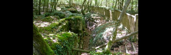
The orders were to keep going until the end. They had been obeyed. The deputy for Drancy, Colonel Driant, asked to join the front as appropriate to his rank and is put in charge of a half-brigade making up a corps of two battalions of chasseurs: the 56th and the 59th reservist battalions, north of Verdun. Driant, a politician as well as an officer, always spoke his mind, and wasted no time observing and commenting on the organization of the Verdun section. Not that his comments stopped the attempts to dismantle the fortifications of the town, even though intermediary positions had barely been considered. Commanding his chasseurs with an affected simplicity that was not without rigour, he could do nothing but organize his section and wait for a storm that, with cruel clarity, he had foreseen. From 20 January, Driant had been talking about this final test in his agenda to his half-brigade. Here is that text, with the lines that predict the unprecedented form that the battle to come will take underlined. Agenda - 20 January 1916 "The time has come for the two battalions to prepare themselves for action, and for every man to think about the role that has fallen to him. It is imperative at every level we have that in a battle as piecemeal as the one ahead, not one man uses the lack of orders as an excuse to do nothing". Communication was frequently interrupted, and soldiers often found themselves left to their own devices. Resisting and stopping the enemy by any means necessary had to be the predominant thought in the minds of each and every chausseur, especially when they were reminded that only the injured had been left in the hands of the enemy in any of the battles they'd been in over the past 17 months. The chausseurs did not surrender. On February 21, he got up early and looked up at a dazzling sun in a magnificent sky. He took off his wedding ring and gave it to his secretary. "If I'm killed, please bring this to Madame Driant." He mounted his horse at Bois des Caures, and was followed by his groom. It was 6.45am, and he went to the worksite where a reserve company under the leadership of Lieutenant Leroy and Lieutenant Simon were building a tunnel. He made them stop their work and sent them to the battlefield. While he was talking with a couple of officers, the first shell exploded: the tragedy had begun. The humid terrain of Bois des Caures (in local patois, caures means hazelnut tree) was not easily adapted to being hollowed out for such heavily trafficked trenches. The 56th and the 59th BCP had organized a system of redoubts, but their tragic weakness was gabionade. This was the state of play when he experienced the shock of February 21, 1916. The Bois des Caures and the bois d'Haumont to its left were right in the Germans' offensive axis. The bombing destroyed the fragile entrenched positions in the face of 150, 210 and 305. Driant himself had even written the night before, "they might attack tonight or they might wait another few days."

The Battle of Verdun Begins

By February 1916, Lieutenant-Colonel Driant's group of chausseurs had been occupying the Bois des Caures section since November. The group was made of the 56th reservist battalion (Captain Vincent) and the 59th reservist battalion (Commander Renouard). For several weeks, on the orders of Driant (who wanted an attack to be imminent), the two battalions had been alternating on the front, strengthening their positions and improving their defences. At 7am on 21 February 1916, the first shell was fired on the forest and Driant, knowing that the time for sacrifice had come, appeared amidst his chasseurs. He was never to leave them again. The bombing became so intense that the entire battlefield was covered in mines. From 10am, it was impossible, total chaos. At 5pm the bombing suddenly stopped, then firing began again, extended this time. It was rapid fire, often hand-to-hand combat. Despite extraordinary displays of heroism, several trenches were taken. By nightfall, the enemy had control of some of the front trenches. But chasseurs from Robin's company counter-attacked in the cold night, took back their trenches and sowed panic in the hearts of the Germans, who thought that the chausseurs had all been taken out of combat. Colonel Driant toured the section around midnight, going to the farthest trenches to encourage each and every one of his men.
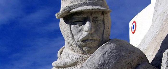
On morning of February 22, while the chasseurs were taking back the trenches they lost the previous night, they were also within grenade range of the enemy. At 7am, bombing began, as intense as it was the day before. At midday it stopped. The surviving chasseurs ran to their posts. Their Colonel was amongst them, he took a gun and fired the first shot. The Bois de Caures could no longer serve for cover. It was surrounded by the enemy. Three companies at the front were taken down by two regiments and died at their posts. Seguin's company worked wonders. They fought with grenades until they were all gone, then with stones, then with the butts of their revolvers. At 1pm, there was a fresh attack. Driant, still with a gun in his hand,was atop his command post with his liasion officers. He was on top form. A superior marksman, he announced the results of the combat and aiming errors. SIMON's company counter-attacked, even taking prisoners. At 4pm, only about 80 men remained around Colonel Driant, Commander Renouard and Captain Vincent. Suddenly, shells started coming from behind. So the Bois de Caures was taken. It was the end. In the hope that he could continue to fight elsewhere, rather than going to prison, Colonel Driant decided to retreat behind the wood. They left in three groups -- the Colonel's group contained the liaison officers and the telegraphers. Everyone forced himself to jump from shell hole to shell hole, while a German 77 fired the whole time. The Colonel walked calmly, taking the rear, with his cane in his hand. He had just put a temporary bandage on a wounded chasseur when he is hit by a shower of bullets. "Oh my! My God!" he shouts. The Minister for Nancy was brought down by the enemy on this patch of Lorraine soil. Of the 1200 chausseurs in Driant's charge who fought against the 18th German army corps, only about 100 remain. The Krönprinz was expecting the battle to last just a few hours. This unforeseen two day setback gave the reserves time to arrive. Verdun would not fall. This commemorative plaque was a gift from the "Lieutenant Colonel Driant" class from Saint-Cyr on the occasion of their 20th anniversary and the 70th anniversary of their patron's death.


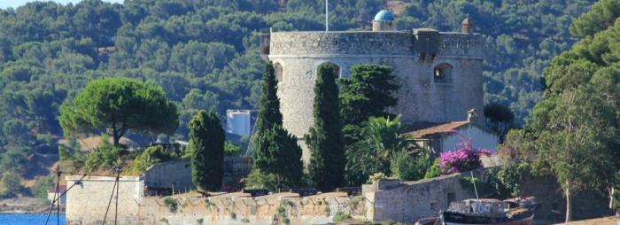
Battles of the Right Bank 1874-1914 - Verdun: border town

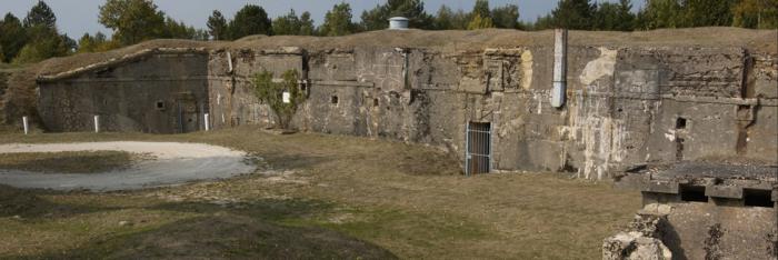
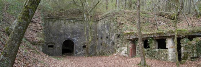
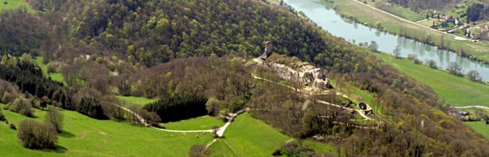
Verdun, transformed into border post when Alsace-Lorraine is annexed in 1871, quickly became the key piece in General Séré de Rivière's plan of defence for the eastern border. The elevated areas around the town and its strong but diminutive citadel were doubly fortified between 1874 and 1914 with concrete shells and armour-clad turrets. The main structure extended over a permitre of 45 km, consisting of forts and fortifications. Smaller elements punctuated the landscape (combat shelters, ammunition magazines, entrenchments, artillery positions) offered support. This impenetrable shield held around 66 000 men during wartime, boasted 185km of narrow military rail track, houses barracks, arsenals, training grounds, an airship park and an airforce camp. While pivotal to the French war effort in 1914, it was largely stripped of its defences the following year, when the Germans launched the "judgement" offensive -- a quick, brutal, and decisive blow.


1916 - Verdun, a ten-month battle

For 300 days and 300 nights, on the little pocket of fortified land known as the Hauts de Meuse, the largest battle history had ever known brought together humans and materials in numbers never before seen, and constituted a turning point in the Great War. It was here, in this hellish crucible constantly bombarded by 60 million shells, where 300 000 men died or disappeared and 450 000 were injured, that the soldier at Verdun lived and died. French and German, alone or in small groups, abandoned in shell holes filled with dead bodies, poorly nourished, faced with cold, thirst, and mud, with fear, with madness and dispair for company and orders simply to attack or defend. From 21 February on, the shower of "Trommelfeuer" shells hacked at the French positions. In the destroyed Bois des Caures, even a 36 hour long fight could not stop the assault. On 25 February, Fort Douaumont was taken. The situation became critical, and the likely fall of Verdun caused the last remaining civilians to make their escape. On the 26th, the newly appointed General Pétain decided to fight a defensive battle on site: he reorganised positions, rearmed the forts, and sent men and supplies to the front via the Voie Sacrée. The offensive was limited by the desperate sacrifices of soldiers, and ran out of steam. In March, Falkenhay, the German commander in chief, increased his attack on the left bank: there was an intense battle at Avocourt, on the slopes of Mort-Homme and Cote 304. On the other bank, on those sections of Vaux and Caillette whose bitterly fought ravines came to be known as "ravines of death," the front wavered but did not cede. Cote 304 and the lines of defence at Mort-Homme and Cumières were taken in May, but every metre lost or gained iwas done so at the cost of massive losses of life. Fort Vaux, which is attacked on 9 March and taken on 7 June, instigates a death cry that quickly reaches the Franco-British offensive on the Somme. On 23 June, 50 000 German soldiers marched on the final hills leading to Verdun, occupiemont Thiaumont and the destroyed town of Fleury but fail to take Froideterre. On the 11 and 12 July, at the same time as the offensive was launched on the Somme, a final German attack came to an end outside Fort Vaux, just 4km from Verdun. This confirms the impossibility of predicting the final outcome of this war. Once the German offensive had been stopped, the other side took the initiative. Fleury was retaken on 17 August, and throughout the autumn the attempts to reconquer meant that danger was redirected away from Verdun. Fort Douaumont was reclaimed on 24 October, Vaux on 2 November. By December, most of the lost terrain had been retaken. But it would take another two years, and the support of the Americans in 1918, to get the front back to the Bois des Caures.


From the Argonne to Saint-Mihiel, four years "under Verdun"

From the Argonne to Saint-Mihiel, four years "under Verdun" The war was developing in the Meuse as early as August 1914, circumnavigating then isolating the fortified town of Verdun. After the terrible affair at Vaubécourt-la-Vaux-Marie on 10 September, the front was positioned on the Argonne's barrier massif. The violent battles at Hauts de Meuse between the 20th and the 25th led to a Salient being built around Saint-Mihiel, cutting off the Meuse and its roads and rail 30km from Verdun. Resistance at Fort Troyon meant that it could not be totally surrounded. For four years, the "hills," ridges and mounds around Verdun were the site of horrific battles. Underground, in the earth at Eparges and Vauquois, enormous funnels bear witness to the mine war and the explosions that swallowed up men and trenches alike. Only in the autumn of 1918, when two American offensives and the sacrifice of 120 000 "Sammies" loosens the net, could the Saint-Mihiel Salient be retaken and the Meuse-Argonne region come back under French control.


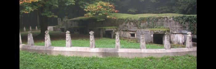
LeDriant's many graves

According to the 23 March 1916 report of chasseur Paul Coisne of the 56th reservist battalion, interned at Camp Cassel and witness to Lieutenant-Colonel Driant's final moments, his last words were "Oh ! là, là, mon Dieu !" ("Oh my! My God!")
Baronness Schrotter of Wiesbaden sent a condolence letter to Madame Driant via a Swiss intermediary on 16th March 1916. She wrote: "My son, an Artillery Lieutenant who fought next to your husband, asked me to write to you and to tell you that Monsieur Driant has been buried with every respect and every care, and that his enemy comrades dug him a handsome grave, and decorated it (...). They are going to look after the grave, so that you will be able to visit it when peace comes (...)". Maurice Barrès, quoting this letter dated 9th March 1916, wrote the following in the Echo de Paris: "Here is the German letter that ends the life of a great French man." Lieutenant-Colonel Driant is remembered with pride in the Tomb of the Brave at the musée des Chasseurs, which is housed at the service historique de l'armée de terre at Vincennes. The story of Driant's many graves is a complicated one. After his death, the Germans buried him on the battlefield. It wasn't until 9th August 1919 that he was exhumed, identified and then buried again at the same location. He was exhumed again on 9th October 1922, with the aim of transporting his body to the Bois des Caures monument. This happened on 21st October, the day before the monument was inaugurated.

> Return to results

Practical information

Address

55100
Haumont-près-Samogneux

Weekly opening hours

Accessible toute l'année

The destroyed village of Montfaucon

Vue générale. ©Mairie de Montfaucon

The hillock of Montfaucon overlooked the surrounding countryside and provided an excellent observation post that the Germans occupied from the first days of September 1914 ...

Montfaucon in the words of E. Pognon, Montfaucon historian, 1885 The ancient collegiate church overlooks the whole village in the form of a magnificent crown... Close by rises the impressive form of the Hospice... The houses are arranged around these two monuments on the slope of the hill. The entire collection of buildings is drowned in an ocean of greenery and fruit trees.

The monument This monument was erected by the American Battle Monuments Commission, a US Government agency, which is also responsible for its maintenance. The Montfaucon monument commemorates the Meuse-Argonne offensive. During 47 days of fighting, from 26th September to 11th November 1918, the American First Army forced a general retreat along this front. The top of this hill was taken on the second day of the attack. It is the site of the former village of Montfaucon which, after its destruction during the First World War, was later rebuilt a few hundred metres to the west. The ruins of the church of Montfaucon can still be found just behind the monument, though very little remains of the old village. The highest point between the Meuse to the east and the Argonne Forest to the west, this hill has been the scene of many bloody battles throughout history.
The monument, which reaches a total height of 60 metres, is crowned by a statue symbolising freedom; it faces the front line of the American First Army on the morning of 26th September 1918 when the attack began. Visitors can go up to the observation platform (opening times are displayed outside) from where they can enjoy a magnificent view of virtually all the terrain captured during this offensive which, at the time, was the biggest battle in American history. The construction and maintenance of this monument are the responsibility of the American Battle Monuments Commission, a US Government agency. The land was given freely, in perpetuity, by the French people. Further information is available at the visitor reception office near the car park, or from the Supervisor of the Meuse-Argonne American Cemetery at Romagne-sous-Montfaucon, approximately 9 km north of this monument.

> Return to results

Practical information

Address

55270
Montfaucon-d'Argonne

Weekly opening hours

Accessible toute l'année