From the coast to the city centres

From the Normandy beaches to the bombed, occupied, liberated cities, internment camps to ‘martyr’ villages, the landscapes inherited from the Second World War have been taken over once again by civil society and the authorities, to be made into sites that bear witness to events dating back more than 70 years.
When looking for the traces left behind by the Second World War in France - and here we will restrict ourselves to metropolitan France - we must begin by casting our eyes to its edges, its external limits, its 3 427 km of coastline. Unlike the First World War, which was played out along its terrestrial borders - from the Vosges to Lille, captured and lost only to be recaptured time and again, in a frontal movement of rival armies - from 1940 the focus shifted towards the outside. Thus the first landscape that comes to mind is the now open mesh of bunkers along the beaches, stretching from Zuydcoote, north of Dunkirk, down to the southwest, and from Perpignan across to Ventimiglia. Sometimes only a few hundred metres apart, these immense concrete observation points, known as blockhouses, were intended to prevent an enemy invasion that could only come - at least, on the western side of Europe - from the sea. Like the Maginot Line, scorned by Wehrmacht divisions at the beginning of the war, the Atlantic Wall did not hold back the Normandy landings of 6 June 1944.
THE COASTLINE, A PLACE OF PILGRIMAGE
The coastal wall now has - at least at the sites of the most crucial or heroic events - monuments firmly anchored to the ground, sentinels of memory that nothing can shift, unlike the bunkers themselves which, subject to the movement of the sands, will ultimately be wiped out. Indeed, one frequently notices how these at once modern and archaic strongholds are moving, slowly but surely, towards the sea, to bury there, a little guiltily, not only their impregnable appearance, but also their complete futility. They are reduced to climbing objects or occasional targets for compulsive taggers. With one surprising detail: the ease with which such unnatural masses - some have walls several metres thick - blend into their surroundings, just as nature, in return, absorbs them into its landscape.
But perhaps they are what makes the French coastal landscape unique, in much the same way as the ice-cream and doughnut carts, or the fishermen’s huts on stilts. Might the German bunkers paradoxically belong to the ranks of these second natures that give the French beaches their originality? And we have yet to mention the life that animates these shores. Alongside sunbathing holidaymakers, fine weather brings waves of tourists to the coast, cameras in hand, to take pictures of these historic sites, walk around the vast cemeteries and read the information boards at one spot before moving on to the next, until exhaustion (or sunstroke) gets the better of them. The landscape of war, pacified by memory, has thus become a place of pilgrimage on this side of France - as had already occurred along the terrestrial fronts of the First World War. If war fashions nature by devastating it, as in the First World War, or reshaping it, as in the Second, the landscape does not allow itself to be disarmed and secures a victory by attrition on which nature, without its aid, could not have counted. In short, war is destined to be subsumed by the landscape, where it had strategically taken up position.
PALIMPSESTIC CITIES
Extensive as it is, the coastline is just the beginning. One has only to go a little way inland to discover a completely different side - this time in photographic negative - of the mark left on the country by the war. Le Havre, Caen and Royan, to name but three among dozens, are palimpsestic cities which no longer show any sign of the devastation they suffered. They were among the targets of the Allied bombings launched in June 1944, yet today, long parallel and perpendicular façades, in the style of the 1950s, rise up in their thousands on the craters that riddle the ground. Unlike Berlin, none bears any scars, not even the relic of a half-crumbled belltower, like that of the Kaiser Wilhelm Memorial Church, in the centre of the German capital.
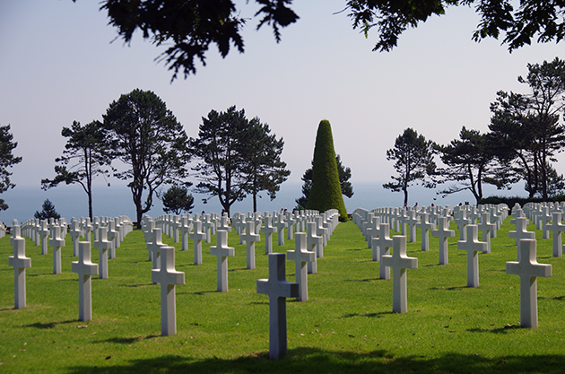
Normandy American Cemetery, Colleville-sur-Mer. © J-L. Faurie / Roquecave
The urban landscape left behind by the Second World War presents a surplus of ‘newness’. Buildings reduced to rubble have been replaced by Haussmann-style neighbourhoods, once densely built-up areas have been opened up; everywhere, more uniform, rational architecture, often required by the urgency of reconstruction, has substituted the organic disorder of the urban fabric, altering the natural metabolism of the cities: the pace of ageing and growth, the balance between ancient and modern. Besides marking the physical landscape of cities, architectural anachronisms have affected their scale, light and human circulation. They have reshaped not only the itineraries on the ground, but also the sky. The devastating passage of the war altered the layout of cities so radically that its presence is no longer discernible; their vanishing lines have been changed and, with them, lines of movement and vision. Old city centres lost their prestige with the disappearance of their surroundings, despite efforts here and there to recreate a ‘natural’ setting around churches and other buildings that were spared. Standing in open spaces or among anonymous constructions, these appear to murmur of their isolation, their uprootedness even, and sometimes to shout it out in a language which is not understood by the new generations of buildings. Thus, passers-by become unwitting translators of these multiple languages, through which this war landscape is conveyed, in the familiar, unnoticed, commonplace setting of day-to-day practices.
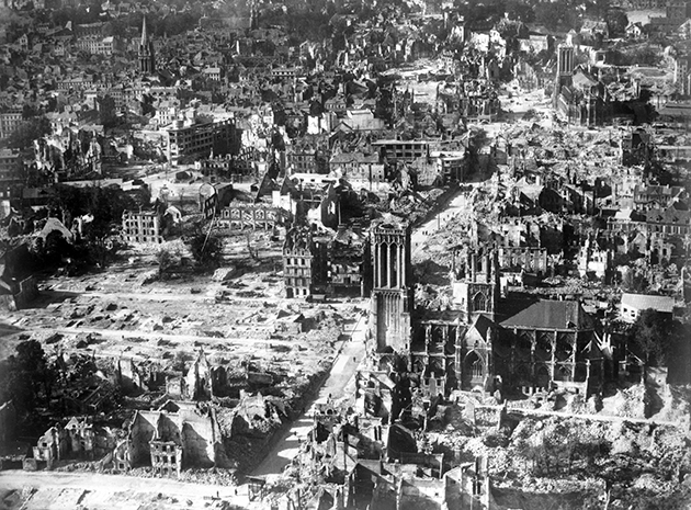
Aerial view of Caen (Calvados) after the bombings and the Battle of Normandy, 1944. © Roger-Viollet
These landscapes trace temporal boundaries that separate us definitively from the images left behind by the literature and paintings of the past: for instance Proust’s Normandy, or Caen’s ‘saved’ churches (pastiches and mixtures) which, since the Allied bombings, have skin grafts and artificial limbs - Saint-Étienne-le-Vieux with its ruined nave, Saint-Pierre which lost its tower, rebuilt in 1957. Here and there, manifested in new constructions, one finds an ‘archaeological’ concern to highlight a ghost landscape behind a new building, such as the Synagogue du Quai Kléber in Strasbourg, which was replaced by the Synagogue of Peace on another site, but whose original location is shown by a mark on the ground and the name of the tram station. Paradoxically, with the destruction of that synagogue, built in 1898, came the disappearance not only of an important stratum of Jewish life, but also of one of the traces of the German presence established here after the Franco-Prussian War (1870-71). There are many other examples of how erasing the past can obliterate the multicultural heritage of some places, sometimes due to older conflicts, so that that heritage now has to be gleaned from sparse, concealed signs. Generally speaking, the fragments of war landscapes subsist today only in superimposed, constructed marks, whose interpretation depends on the attention of the passer-by.
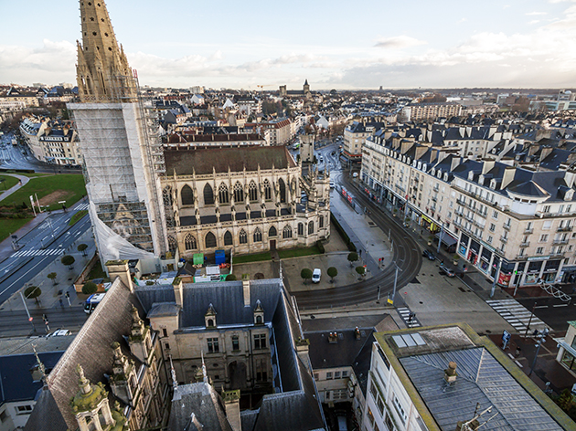
Aerial view of Caen (Calvados) today. © A. Poirier / Ville de Caen
CAMPS IN PARIS
Often, the war landscape blends into the urban palimpsest, where there is nothing to break up the continuity and the scars of violence have disappeared, so that no visible trace remains to reveal the past to the unsuspecting observer. Catching the train at the Gare d’Austerlitz (where a plaque was installed in 2010 by the Association of Sons and Daughters of French Jewish Deportees to remember the deportations of 1941 and 1942), or having a drink on the terrace of the Hotel Lutetia, does not necessarily conjure up in people’s minds the mental landscape of the Second World War. The purpose to which some of these places were put during the war is well known (even if the Lutetia is better known as a repatriation centre for deportees than as the headquarters of the Abwehr during the Occupation) or else signalled by plaques. One example is the Maison des Sciences de l’Homme, which was built on the site of the former Cherche-Midi prison, where Resistance fighters were incarcerated and tortured and where Dreyfus was sentenced in 1894. Another is 21, rue de la Boétie, which housed the Institute for the Study of the Jewish Question. Others are ‘impassive’ sites, like the many town houses of the 16th arrondissement that were home to the French Gestapo (52, boulevard Lannes, 180, rue de la Pompe, 101-105, avenue Henri-Martin, 93, rue Lauriston), the naval headquarters (2-10, boulevard Suchet), the headquarters of the reserve detachment of the Waffen-SS (24, avenue du Recteur-Poincaré), Reich Security, or SiPo-SD (31, 58-60 and 72, avenue Foch). In recent decades, some have taken on a new mnemonic quality, where a plaque invites the passer-by to take a detour from a familiar route. Often, it is individuals - writers, artists, researchers - who have woken them from their lethargic slumbers, for example Anne Sinclair with her 21 rue de la Boétie, Sarah Gensburger and Jean-Marc Dreyfus with Des camps dans Paris, not to mention Patrick Modiano’s Dora Bruder: two decades after the book was published, a Parisian street was named after its heroine, of which no trace remained after the opening ceremony.
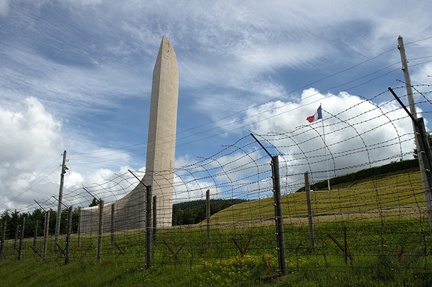
Deportation Memorial, site of the Natzweiler-Struthof Concentration Camp, August 2009. © T. Ruffer / Ullstein Bild / Roger-Viollet
Any war, especially one involving occupation, brings terror beyond the battlefields, where it can be supplanted by glory. It affects a powerless population, sometimes left to fend for itself, and in this case split along racial lines: native-born French, foreign Jews, French Jews, gypsies, Spanish, German, Italian refugees, etc. Thus, away from the cities, in the bucolic serenity of the French countryside - “green holes where a river sings” - a few red marks remain as they were, planted in the national scenery. Some were quickly given heritage status and came to serve as models; for others, it took several decades for this to happen.
PLACES OF DEATH
When the war was over, it was decided that the ‘martyr’ village of Oradour-sur-Glane would preserve as they were the ruins of the massacre perpetrated by the SS, in which 642 villagers were killed. As in villages across Italy and Greece, such acts of violence were committed by troops in retreat or on their way to other fronts, on the pretext of terrorising a population suspected of aiding the rural resistance. Visitors walk among ruined houses and the rusty remains of everyday objects (the wreck of a car being the best-known), among heaps of rubble where, before 10 June 1944, the villagers would congregate, and commemorative plaques on the spot where groups of victims of all ages were gunned down or burnt. A feeling of anachronism emanates from this place, where marks left untouched coexist with old-looking signs that are in fact very recent. The same is true of the plaques of corten steel (highly resistant, industrially oxidised steel used in construction) of the new memorial. Their at once hyper-modern and rusty appearance announces, by a curious contiguity effect, the now rusted scrap metal found around the preserved village.
The permanent exhibition in the documentation centre adjoining the memorial draws a brief analogy between the terror wreaked by the Einsatzgruppen on the Eastern Front and such crimes committed in France (in particular at Tulle, a few days before Oradour), but a line can also be drawn between what happened in the heart of Limousin and across the Rhône at Vassieux-en-Vercors and Izieu.

The former Rivesaltes camp. © K. Dolmaire
Vassieux was the scene of fighting between the resistance and attacking German paratroopers, which left the village devastated; at Izieux, 44 Jewish children were rounded up on the orders of Klaus Barbie, none of whom survived deportation to Auschwitz. In a sad irony, that line crosses the green volcanic hills of the Auvergne, at the foot of which lies the booming town of Vichy. Untouched since the late 19th century, Vichy nevertheless mourns eight of its nine hotels - only the Aletti survives - which were home to senior civil servants of the Pétain government, diplomats and grey or black-uniformed Nazi officers.
MAPPING COLLABORATIONIST REPRESSION
Meanwhile, it was necessary for time to pass and postwar political tensions to abate before the French camps were incorporated in the national landscape. Besides, the repressive purpose of a number of them continued after the war was over, in particular for the internment of gypsies, while the first camps were opened just before war broke out, to contain the wave of Spanish refugees fleeing Franco’s forces, whom the Decree-Law Daladier (May and November 1938) classed as “undesirables”. We know that this structure was then reproduced throughout the country, to hold foreign Jews to begin with, then French Jews, while they awaited deportation and death in the Nazi camps. Their names alone, etched in the national memory, serve as reference points for mapping French collaborationist repression: Drancy, which, aside from its monuments, only gained a memorial and documentation centre in 2012; Compiègne; the camps of Loiret (Pithiviers, Jargeau, Beaune-la-Rolande), Gurs, Rivesaltes; Montreuil-Bellay, where gypsies were interned up until January 1945; Natzweiler-Struthof, in Alsace, classed as a ‘Major National Remembrance Site’ since 2014; and dozens of others across the country.
Just as their period of operation exceeded the start and end of the war, so these camps take us to border areas not restricted to Alsace or Spain. They trace a broad outline which extends the war landscape across the whole of Europe, transforming it, through the filter of tourism, into a landscape of remembrance.
Personalities
Related articles
- 1930 - 1940 La ligne Maginot
- Le mur de l'Atlantique
- Histoire de la fortification bretonne
- After the Liberation, rebuild a country in ruins ...
- Oradour-sur-Glane, 10 juin 1944
- The attack on Tulle, 7 and 8 June 1944
- Les pendaisons de Tulle
- Vassieux-en-Vercors, village martyr
- L'internement : La France des camps (1938-1946)
- Les camps d'internement dans les Hautes-Pyrénées (65)
- L'internement des tsiganes en France 1940-1946
- Camp d'Internement pour les Tsiganes, Montreuil-Bellay (49)
- Les camps dans les Pyrénées-Atlantiques (64)
- Les camps dans le Gers (32)
- Les autres lieux d'internement en Ariège (09)
- Les autres camps dans le Tarn-et-Garonne (82)
- Camps dans les Pyrénées-orientales (66)
- Fusillés et déportés du Nord-Pas-de-Calais