Geological view of the Chemin des Dames

A favourite walk of Louis XV’s two daughters, the unique topography of the Chemin des Dames meant that it became a strategic sector in the fighting in the Aisne in 1914. This sector revealed how geology as a science could play a major role in shaping the events of the First World War.
The Chemin des Dames is situated on a ridge line of strategic importance. The scene of a battle under Napoleon in 1814, the site was fortified after the Franco-Prussian War (1870-71) to defend Paris. It stands on a hill, whose limestone summit several dozen metres thick has large numbers of underground quarries known as creutes dug into it, forming so many shelters. During the four years of the war, this ridge played an important part in establishing the front line.
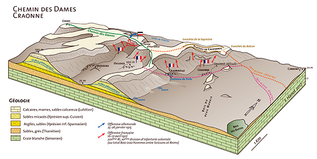
Block diagram of the Chemin des Dames. This roughly east-west oriented escarpment is one of a number of isolated outliers of Tertiary land topped by a limestone plateau from the Lutetian stage. The mound of Laon and the Forêt de Saint Gobain massif
further north have the same geological origin. The Chemin des Dames plateau is bordered to the north by the Ailette Valley
and to the south by the Aisne Valley. On maps and aerial views, it is shaped like an oak leaf, a morphology resulting from erosion. © F. Hanot, 2017
1914-18: HOLDING THE CHEMIN DES DAMES
In the summer of 1914, the Germans crossed the sector, then retreated there during the course of the First Battle of the Marne. Between 13 and 15 September, the British and French tried to dislodge them, but without success. The sector became quiet. The Germans built their fortifications on the ridge line, while the French occupied the flanks.
The French offensive on the Chemin des Dames got underway on 16 April 1917. The losses were considerable due to the layout of the terrain. From 20 May to the end of June, mutinies broke out. The Germans heard about them, and took advantage to launch a counter-attack. Between July and November 1917, French and Germans cohabited sometimes at very close quarters, particularly in the Caverne du Dragon (‘Dragon’s Cave’). In October 1917, over 500 Germans were entrenched in the galleries of the Montparnasse quarry, a key position dominating the plateau and the Laon-Soissons road. The French held the Chemin des Dames, but in May 1918 a fresh German offensive retook the sector. It was not recaptured until July 1918.
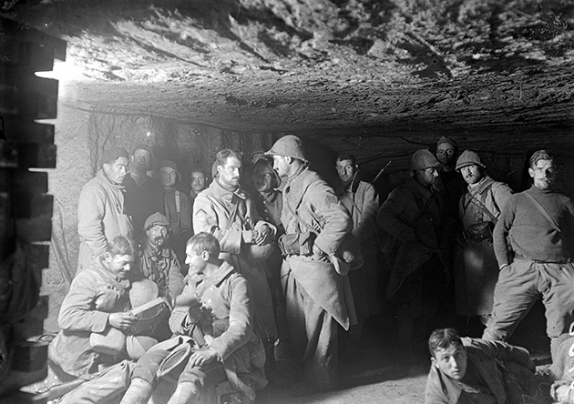
Chasseurs stationed in the Montparnasse quarry, La Malmaison (Aisne). © E. Mas / ECPAD / Défense
A UNIQUE TERRAIN
Located to the north of the River Aisne, this region’s unique topography divides it into two distinct parts. To the north, the Soissonnais corresponds to a vast plateau, deeply gashed by water courses. The Chemin des Dames is an isolated subsection of that plateau, intensely dissected by the Aisne and the Ailette. It represents a natural fortress. Erosion here has been so great that there remain in places only narrow strips (Coucy) or isthmuses (Hurtebise). This complex topography is also marked by indentations known locally as cuves. Meanwhile, to the north, the Laonnois is comprised of isolated outliers including the Forêt de Saint Gobain massif and the mound of Laon.
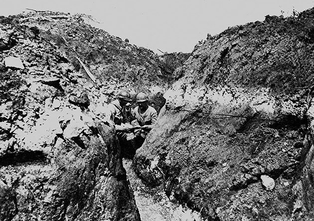
A French trench on the Chemin des Dames, 1917. © Roger-Viollet
The part of the plateau occupied by the Chemin des Dames lies at an average altitude of 190 metres. The chalk outcrops to the east, at the foot of the hill, at a height of around 60 metres at Ville-aux-Bois-lès-Pontavert. The terrain of the Chemin des Dames is thus comprised of a pile approximately 130 metres thick of land from the Tertiary period. These layers accumulated over 50 million years and were originally continuous. Mostly they formed in a marine environment, in a sea which lay at first to the north, then to the west.
Approximately two million years ago, the upthrust of the north of the Paris Basin increased, causing a major upheaval. This resulted in the layers inclining in a gentle slope towards the south. Erosion by water courses ate into the softer ground (sand and clay) and preserved in the form of relief the harder ground (limestone).
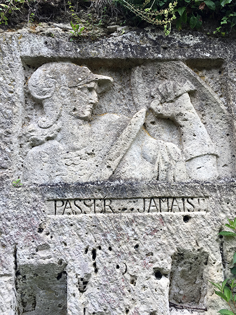
Example of a sculpture in the Montigny quarry at Machemont (Oise), made by a legionnaire named Bucher
(5th Company of the Foreign Infantry Regiment). © F. Hanot
Aside from the ground, the presence of water also made the sector unique. Water which penetrated into the ground would have been stopped first of all by the clay of Laon, forming a series of small sources. Deep in the ground, diffuse yet perennial water sources were at the origin of most of the villages on the southern slopes of the Chemin des Dames.
Every village, every farm, every chateau had its own quarry in the sandy Lutetian limestone. It was from this stone that the region’s rich architecture was born. Worked for centuries, these quarries form a sprawling maze with many branches. The quarries of La Malmaison farm, Bohéry and Château de la Motte are perfect examples. The ravines are similarly all dotted with old stone quarries, which provided impregnable refuges.
GEOLOGY AT THE SERVICE OF MILITARY STRATEGY
Topography has always been of strategic importance. Holding the high ground is crucial. That is what the Germans did following their retreat during the First Battle of the Marne, in September 1914. Their position was even firmer because the edge of the plateau overlooking the Aisne Valley, to the south, was covered in creutes, which made ideal positions for machine guns. These underground quarries had sufficiently thick roofs to stand up to bombardments.
Between the vast Montparnasse quarry (known to the Germans as Barbarossa Höhle) in the west and the Dragon’s Cave (Drachenhöhle), the escarpments of the Chemin des Dames comprise more than a hundred creutes, which the German troops used as shelters. They served different purposes depending on their position in relation to the front line.
Those on the front and in the sector of the Californie plateau, above Craonne, were impregnable positions looking down on the arduous slopes of the plateau.
Those to the rear were favoured as barracks and aid posts, because they offered protection and mild temperatures. Long periods of waiting gave the artistically inclined the opportunity to express their talents, leaving behind genuine works of art or poignant testimonies.
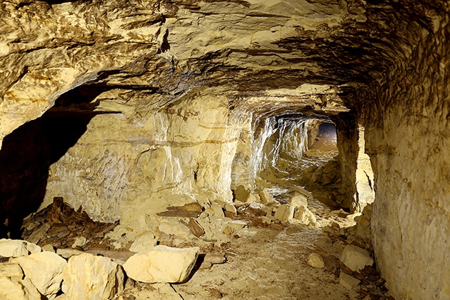
German tunnel beneath the Chemin des Dames. © J-P. Batteux
THE GERMAN TUNNELS
The Germans took advantage of the geology, in particular the presence of unconsolidated sandstone (sables du Cuisen) beneath the Lutetian limestone. These galleries, dug out of the sandstone and with simple wooden struts, were supported by a resistant limestone ceiling, allowing the soldiers to link up with other tunnels over several hundred metres.
The tunnels did not all have the same purpose. Some linked old quarries with the rear, such as the Froidmont creute (Tauentzien Höhle) and Vaumaires ravine, at Braye-en-Laonnois, or the Dragon’s Cave and the northern slope of the plateau. Others were not aligned with creutes. These served as passages to the first-line or support trenches, being out of sight of the French troops.
In the preparations for the terrible offensive of April 1917, the French artillery had practically no impact on these underground structures. Besides the difficulties the French infantry had in advancing up the muddy slopes, they faced a deluge of fire. The Germans were thus greatly advantaged by the presence of these tunnels. These often unknown underground workings therefore played a dominant role in the outcome of operations. Situated in the German sector, they were rarely included in the master plans and only brief references were made to them in some diaries and operations logs.
Geology played a decisive part in the outcome of the fighting on the Chemin des Dames, but it also had a key role in many other sectors of the front. As well as the digging of galleries and the supply of water, geologists’ expertise went into many other unusual and lesser known aspects. For instance, trafficability maps were drawn up for tanks, and expertise in aviation compass materials and quartz crystals was used to develop the first sonars for detecting submarines.
Geologists were also in demand for the applied part of their field, i.e. to find raw materials for the war effort: copper, aluminium, antimony, mercury, tin, tungsten, etc.
Franck Hanot - Chair of CDP Consulting / Frédéric Simien - Manager, Éditions du BRGM