Newsletter

Fort Rapp-Moltke

Fort Rapp-Moltke. Source : http://julienviel.hautetfort.com/culture/

Inaugurated on 26 September 1874, Fort Rapp-Moltke was part of the fortified ring around Strasbourg.

The speed at which Strasbourg fell, on 28 September 1870, after 46 days of siege, prompted the German High Command, under the authority of General Von Moltke and Von Kameke, to formulate a defence plan for the Empire’s western borders that planned to turn the towns of Cologne, Metez, Thionville and Strasburg into fortified camps, protecting their perimeters by a ring of armed forts.

The defensive ring around Strasbourg

Strasbourg was thus protected by a ring of detached, half-buried, heavily fortified and armed structures, even before the construction of the new urban line of fortifications that would be started in 1876 after the commissioning of the first forts. The works began in 1872, under the direction of the engineering officers Hauptmann Stephan (Fort Rapp) and Volkmann (on the Rhine side in the northeast to pass over to Kehl on the right bank via the southeast).


Fort Reichstett (Moltke) was inaugurated on 26 September 1874. Eleven structures were built in Alsace covering a perimeter of nearly 35 kilometres and three structures around Kehl (in Germany) covering a perimeter of 18 kilometres. The line included forts with dry and wet ditches. The masonry, in dressed standstone from Vosges and bricks manufactured in Rust (Germany) and Achenheim (Alsace), puts these monuments in the Neo-Prussian style. Two to three thousand workers were employed, including Italian bricklayers.


Fort Rapp-Moltke

The outpost covered 4.5 hectares and was made up of some 220 rooms and facilities. The fort comprised: an entrance with a place of arms, guard house, large powder store and guard quarters during peace time; a dry ditch surrounding the fort fitted with a covered way supplemented by a barbed-wire fence; barracks on two levels housed the troops quarters and services (HQ, kitchen, bakery, infirmary, sleeping quarters, washing facilities, etc.) and were equipped with a defence system of the ditch by flanking; an entrance into the fort composed of a gate, draw bridge and reinforced door; a central corridor leading to the casemates; casemates composed of alarm rooms, powder stores, munitions assembly rooms, goods hoist for moving munitions into artillery positions at the top of the fort; front and side parapets surmounting the fort, reserved for artillery pieces.


The outposts were protected by: sheltered corridors, a reinforced observation turret made it easier to keep watch of the front; a double caponier above the front ditch, converted in 1885 to a front battery was built in the counyterscarp with a system of countermines and sewers completing the frontal defence system; adjoining batteries to the left and right. Each fort was defended by 18 cannons (90 to 150 and even 220 mm) in firing position; 18 reserve pieces of artillery in the interior courtyards (cannons and mortars). The short-range defence was assured by 90-120 mm cannons which were later replaced by Hotchkiss 37-mm revolver cannons and 53-mm rapidfire machine guns. The fort could hold 800 men (infantrymen, pioneers, artillerymen and guards) under the command of 15 officers.


An evolving system

In 1885, the discovery of picric acid and the manufacture of torpedo shells triggered a huge crisis in military constructions. High Command decided to take the artillery outside the fort to form the adjoining batteries, reinforce the top sections of the forts with “special concrete” and granite blocks, convert windows in the barracks into fire stands, turn the double caponier into a front-facing battery offering greater protection and equipped with revolver cannons, fit out the walls with counterscarps of metal gates and build the entrance via the ditch, install blast-proof doors at certain access points, and reinforce the fort’s defences with two marine artillery pieces, 150 mm on rails.

From 1890, intermediate structures were built between the forts to block up any gaps; these included infantry, artillery and munitions buildings to complete the defence system. In this year, the fort in Strasbourg lost its strategic importance due to the stronghold erected in Mutzig (1893-1914) that had the capacity for up to 6,500 men with artillery in turrets and armoured shields.

Between 1914 and 1918, the fort was used as a munitions and equipment store then a camp for Russian and Italian prisoners. Alsace-Lorraine was returned to France following the Treaty of Versailles and the site was integrated into the Maginot Line as a rear base for the 226th Infantry Regiment of Strasbourg and a rest centre for the fortress troops based in the fortifications along the Maginot Line along the Rhine. Marine artillery pieces were placed on top of the fort around 1937.


The Ney-Rapp intermediate structure occupied by the 155th Fortress Artillery Regiment, was damaged by an explosion in June 1940. From 1940 to 1944, the German army used the stronghold as a warehouse. It was occupied by the FFI and the first French and American troops during the Liberation. Between 1946 and 1968, the fort was used as a munitions store.

After being decommissioned, the site was allocated to the civil protection department of the French Ministry of the Interior. In 1993, the Friends of Fort Rapp Association was tasked with rescuing, preserving and restoring this military structure. After three years of work, the fort was opened to the public.


Fort Rapp-Moltke

Rue de Lorraine 67116 Reichstett

Contact: mjg.schuler@evc.net


Tourisme 67


> Return to results

Practical information

Address

Rue de Lorraine 67116
Reichstett

Weekly opening hours

Visites guidées d'avril à septembre. Tous les jeudis à 15h ainsi que les 2e et 4e dimanches du mois à 14h,15h et 16h30

Neuf-Brisach

Vue aérienne de Neuf-Brisach. Source : ©Denis DONTENVILLE. http://www.fotocommunity.de

Created in 1697 after the loss of Vieux-Brisach across the Rhine, Neuf-Brisach is the only, yet magnificent, example of Vauban's third system.

In 1697, in accordance with the Ryswick treaties, France had to give back all those towns situated on the right bank of the Rhine, including Brisach. She was thus to lose her foothold in Germany and leave the centre of the Alsace undefended. In 1698 Vauban was despatched to the town and started to build three projects, of which the third one, the most complete, was retained by Louis XIV on 6 September 1698. The highly experienced Vauban, closely following the layout already achieved in Landau, designed a town with a double defensive main front part to increase its resistance to attack and make it less vulnerable to ricochet fire, which he himself had invented.

The town, a perfect octagon, comprises an internal fortified "secure" part, whose fortified defensive walls are flanked by fortified towers and an outer "fighting" area. This is made up of two defensive levels. The first consists of counter-guards serving as an artillery platform, which conceal the fortified towers and tenailles to protect the defensive walls. The second level is made up of half-moons in front of the tenailles, of which only those above the doors have a reduit, and of a covered walkway that encircles the whole town. Within the walls, Neuf-Brisach is arranged into 48 areas around the Place d'Armes. This ias how Neuf-Brisach came to be built from scratch on the left bank of the Rhine a short distance from the old town of Brisach. Construction work, which began in 1700, was carried out quickly so that by March 1702, the town could be used as a defence.
However, the return of Brisach to French rule in 1703 was to be the death knell for Neuf-Brisach. This is why, due to lack of funds, the crowning work that featured in Vauban's plans was abandoned and the first stone of the church of Saint-Louis was not laid until 1731, while the construction of the governor's hall would not be started until 1772. Only a small amount of modernisation work was carried out in the middle of the 19th century to compensate for some defects, in particular the lack of casemates. It was also a question of adapting its defences after the construction of the canal between the Rhone and the Rhine that runs along the slope to the east, by adding a lunette covering a floodgate. After a few alarms in 1814 and 1815, it wasn't until 1870 that Neuf-Brisach was to witness its first siege: besieged from 6th October 1870, it was subjected to violent artillery fire between the 2nd and 10th November before capitulating on the 11th November.
However Neuf-Brisach's military purpose was never to be fulfilled. The Germans would significantly alter the ramparts, as well as the urban layout of the ancient fortified town, turning it into a key constituent of the Neuf-Brisach bridgehead, intended to protect an important crossing point on the Rhine using several very modern fortifications. In June 1940, the breaching of the Rhine by the Germans in the Neuf-Brisach area was to be marked by intense fighting, before the town temporarily became the largest prisoner of war camp in France. Neuf-Brisach was to be severely bombarded once more, this time by American troops at the end of the Second World War.
Tourist Office Point I Neuf-Brisach 6, place d'Armes 68600 Neuf-Brisach Tel. 03 89 72 56 66 Fax: 03 89 72 91 73 E-mail: info@tourisme-rhin.com

> Return to results

Practical information

Address

68600
Neuf-Brisach
Tél. 03 89 72 56 66Fax : 03 89 72 91 73

Weekly opening hours

Accessible toute l'année

The Royal Tower of Toulon

La Tour Royale à Toulon. Source : http://www.photos-de-villes.com

Constructed in 1513 on the orders of King Louis XII, the Royal Tower was built to defend the entrance to the port of Toulon.

From the beginning of the 16th century, the inhabitants of Toulon were heavily preoccupied with sheltering their town from an attack by sea. And although, with its fortified wall dating from the 14th century, Toulon could consider itself sheltered from a sudden attack from the land, its harbour remained entirely open to enemy fleets. Listening to the pleas of the province and alerted by the town council, in 1513 KIng Louis XII ordered the construction of a fortification in the form of a tower in the entrance to the port to defend its access. Originally called the Royal Tower, this fortification was immediately called the Great Tower or the Big Tower by the people, who were amazed at its size. In a municipal debate held on the 16th July 1513, the town council decided that this tower would be built on the cape known as la Manègue, in the entrance to the port, as the king had wanted. The execution of the work was under the supervision of an Italian engineer of great renown, Jean-Antoine de la Porta, who arrived at the port in early May 1514. The work was started on the 14th May, the date of the first excavations, to public rejoicing and would continue, often halted due to financial difficulties, for ten years. The Great Tower was completely finished and armed in May 1524. Command of it was entrusted to the unsavoury individual Captain Jehan du Mottet, famous for the cowardice with which he surrendered it to the Imperials, without a struggle, for 500 gold Ecus, when the latter invaded Provence in 1524. The enemy found 3 canons and 9 other artillery pieces there, which they drove to their camp outside Marseille, opening up the first route through the Ollioules gorges, in order to avoid the harsh climb up the Corps de Garde pass. Amongst the canons taken were the famous culverin, called Lézarde, which was later to cause so much harm to the French on the day of the Battle of Pavia (24th February 1525) and which was partly responsible for the victory. In 1529, the Great Tower was rearmed and as a result was able to resist in July and August 1536, when the fleet of Andréa Doria entered Toulon. It could not, however, prevent it from occupying the harbour during the new invasion of Provence by Charles Quint. During the persecutions suffered by the protestants in the province as a result of the Saint-Barthélémy massacre, about twenty Reformist families found asylum in the Great Tower.

It played no active role during the siege of 1707, but as it was powerfully armed, the ships of Admiral Showel's English fleet did not dare to break through the harbour. Towards the end of the 17th century, this fortress, which had for a long time provided the only defence of Toulon from the sea, was already no longer capable of providing a useful service. However, in 1746, it was still equipped with fifteen 24 canons, ten 18's, four 12's and two 6's, making a total of thirty one canons. From 1770 onwards, which was when Fort Lamalgue was finished, the Great Tower no longer played a major role in the defence of the harbour. The Revolution was to turn it into a jail; many victims were imprisoned and perished there. It had the same use during the counter-revolution of 1793. On the 19th May 1798, Josephine came to the Tower to say goodbye to Bonaparte as he set off on his expedition to Egypt. Although it was a pleasant prison in 1809 for the crew of the English frigate the Proserpine, captured off Sicié on the 27th February, for the duration of the First Empire it would accommodate in a more rudimentary fashion the many draft dodgers awaiting trial or their departure to the companies of pioneers. In 1825, the chapel was demolished and the small cemetery deconsecrated. The Tower had twenty-one canons in 1844. During the Franco-German war of 1870-1871, its basements were used to store the gold of the Bank of France. A project to install a battery of two 370mm canons there was abandoned in 1900. Since then, the Great Tower has been used as a store for naval construction, and to service torpedoes etc. In the 1914-1918 war German prisoners of war were interned there. During the 1939-1945 war it was occupied by the Germans and armed with various weapons, most notably anti-aircraft canons. It was hit several times and was badly damaged during the allied bombardments of 1943-1944. Between 1947 and 1948 it was cleared of rubble and a few minor repairs were carried out. Since the 11th April 1947 it has been listed as a historic monument.
A canon tower, almost circular in shape, 60 metres in diameter, with walls varying in thickness from 5 m to 3 m, it consists of a central nucleus, a low casemated battery with eight embrasures, a platform at access level with a drawbridge and an upper terrace protected by a solid wall forming a parados. It is surrounded by a wide moat. Several modifications have been carried out to the fort over the years: the addition of two low batteries at the end of the 17th century, whose embrasures are now blocked up; the establishment of a barracks on the platform and then a guard house; the development of the upper terraces to accommodate anti-aircraft artillery.
The central nucleus contains a collection of premises laid out on three levels, one above the other and linked by spiral staircases. In addition to two water tanks, there are vaulted halls used as storerooms and dungeons. It was all originally lit by natural light. The nine casemated cells are accessed by a circular gallery. A canon ramp links the stores with the upper terraces, allowing the transportation of artillery and ammunition.
This historic monument, managed by the Ministry of Defence, is covered by a Culture and Defence protocol, signed on the 17th September 2005. Click here to see the list of other buildings ...
Toulon Tourist Information Office Place Raimu 83000 Toulon Tel.: + 33 (0) 4 94 18 53 00

> Return to results

Practical information

Address

Avenue de la Tour Royale 83000
Toulon
Tél. : 04 94 18 53 00

Weekly opening hours

Accessibilité toute l'année

Defence system and fortifications around Langres

Vue panoramique de la citadelle. Source : Office de Tourisme du Pays de Langres

The Langres defence system is one of the only such systems never to have been subjected to enemy fire.


This, as well as its four lakes, means that the Pays de Langres defence system is one of the best preserved in comparison to its original state.


Context

After the 1870 war, Alsace and Moselle were annexed by the German Empire, depriving France of the natural defences provided by the Rhine and the majority of the Vosges mountain range. The country's entire defence system had to be modified. This task was completed by the General of the Engineers, Raymond Séré de Rivières.


Having noted the disadvantaged new borders and the fact that it would be impossible to stop the enemy on them, he decided to construct "defensive curtains" designed to help concentrate and move troops. With strongly fortified towns at each end (Verdun, Toul, Epinal and Belfort), these curtains formed a string of separate forts, preventing any passage. Two large breaches were left (at Charmes and Stenay) for troop manoeuvres.

This system, designed to offer support and openings for a French attack or channel German troops if they broke through, was complemented behind the front line by a second line of immense fortified camps (Besançon, Dijon and Langres). Their role was to support the curtains by coordinating an offensive or strategic retreat.

This colossal project, started in 1874, was practically complete within a decade.


Defensive structure

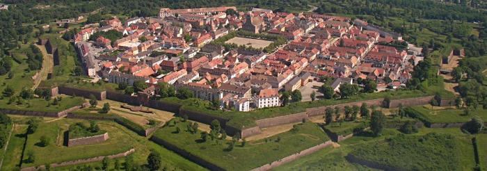
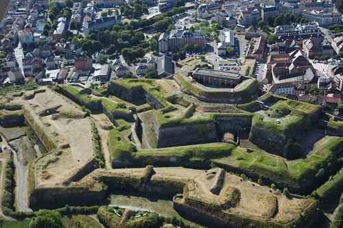
Modernisation of the structure, inherited directly from the mid-17th century, began in the mid-19th century: construction of the citadel (1842-1860), reconstruction of the enclosed town (1844-1856) and the start of work on Bonnelle and Peigney forts (1869). The project was rudely interrupted by the war of 1870. The lessons learned during the conflict confirmed the credibility of detached fortifications, and justified moving these away from the site itself due to rapid progress in artillery. From 1874, the aims of the system at Langres were to: support a reserve army amassed around Langres, provide backing for an army forced to abandon the Vosges or Franche-Comté, shelter the town and supply routes to the citadel from bombing and control the railway lines and prevent the enemy from using them.

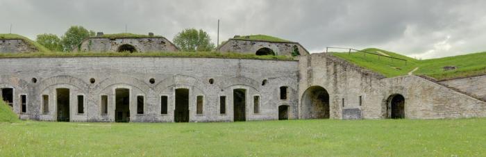
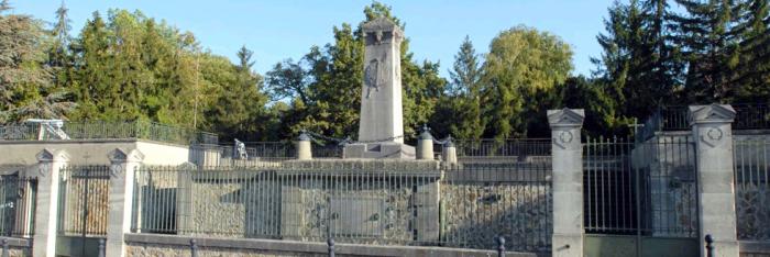
The fortified camp was transformed up until 1893. After a half-century of intensive work it was made up of over forty structures (citadel, 8 detached forts, 20 batteries and infantry structures, 9 underground magazines and 4 strategic wells), linked by 60km of strategic roads.


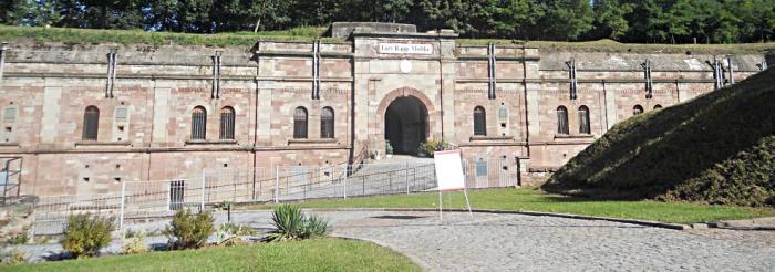
Montlandon Fort (or Mortier Fort) was built between 1883 and 1885, 10km east of Langres. It covered an area of 8.5 hectares and could house 7 officers and 350 men. Today, it has been converted into a farm with accommodation. Visitors can enjoy meals and snacks, buy local produce and visit the fort and farm. Open for visits. Status: private property.


Le Cognelot or Vercingétorix Fort was built between 1874 and 1877 to control the Culmont-Chalindrey railway node, protect an army retreating towards the plateau and play a pivotal role in allowing an army to garrison the east and south-east ridges of the plateau, preventing the enemy from besieging them.

Le Congelot Fort covers an area of 29 hectares and is located 8 kilometres south-east of Langres. It could house 13 officers and 623 men (and up to 1,083 in wartime). As it needed to be autonomous, supplies were designed to last 3 months: in addition to 100,000 individual rations, 585 cubic metres of water (6 litres per man per day) were required. Guided visits are available to individuals every Sunday in July and August except when events are being held. Groups: all year round by appointment.


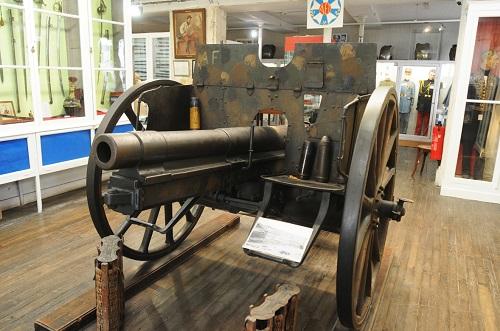
Peigney or Constance Chlore Fort was built between 1869 and 1875, 2.5km east of Langres. It is a trapezoidal point defence fort which covers an area of 18 hectares. It was designed to house 8 officers, 18 non-commissioned officers and more than 336 men. Its weaponry was made up of 49 pieces of artillery (plus 22 in reserve). Status: property of the civilian emergency service.


Pointe de Diamant or Defrance Fort is the smallest fort in the defence system. Its role, in combination with La Bonnelle Fort, was to control the plateau west of the site. It is situated 3.2km from Langres and was built between 1874 and 1877. It covers an area of almost 12.76 hectares and was capable of housing 8 officers, 18 non-commissioned officers, 334 troops and 29 pieces of artillery. Status: the fort, which belongs to a private company, has been abandoned and is therefore not open for visits.


Saint-Menge or Ligniville Fort. Saint-Menge Fort (also known as Ligniville fort after the first Prefect of Haute-Marne) formed an integral part of the 19th-century Langres defensive system. It is located 8km north of Langres. This trapezoidal stop fort covering an area of 22 hectares is equipped with two batteries and a fortified camp. Its construction, on the site of a promontory fort at the point where the Marne valley opens out, began in 1874. Once completed in 1881 it was capable of housing 19 officers, 37 non-commissioned officers, 754 troops and 68 pieces of artillery. Status: private property. Not open for visits.


La Bonnelle or Décres Fort This fort, construction of which had hardly begun at the time of the 1870 war, is the only structure to have come under enemy fire when the Prussians circumvented the fortifications in January 1871. The building of the fort commenced in 1869 and was finally completed in 1885, after two phases of works (1869-1875 and 1881-1885). It is a trapezoidal point defence fort covering an area of 18 hectares. It was capable of housing 13 officers, 50 non-commissioned officers, 610 troops, 4 horses and 45 pieces of artillery. Status: property of Saint-Geosmes village. Open for visits for groups only, by appointment. Contact: Pays de Langres tourist office.


Dampierre or Magalotti Fort is the most distant, but also the largest, of the eight forts of the Langres curtain. It was built between 1874 and 1879 between the Coudre and Traire valleys, and is France's largest fort (52 hectares). It is surrounded by 4 kilometres of ditches and was designed to house 43 officers, 146 non-commissioned officers and 1,350 troops. Its immense size is matched only by its weaponry capability - up to 142 pieces of artillery. Status: property of the Ministry of Defence. Not open for visits.


Plesnoy or Medavy Fort was built between 1877 and 1881, 11.8km north-east of Langres. It is a 38-hectare stop fort designed to house 25 officers, 48 non-commissioned officers, 768 men (and 300 artillerymen) and 47 pieces of artillery. Around it stand four batteries, one of which is built against the fort, and a detached powder magazine at Bois Salicaut. Status: private property. Closed to the public.


Information


Pays de Langres Tourist Office

BP16 - 52201 Langres cedex

Tel: +33 (0)3 25 87 67 67

Fax: +33 (0)3 25 87 73 33


Langres Citadel

52200 LANGRES

Tel: +33 (0)3 25 87 67 67

Fax: +33 (0)3 25 87 73 33

E-mail: info@tourisme-langres.com
 

Pays de Langres

> Return to results

Practical information

Address

52200
Langres
03 25 87 67 67

Weekly opening hours

Visite du Fort de Bonnelle uniquement sur RDV

Fort des Basses-Perches

Le fort des Basses Perches. Source : © Dr Balliet J.M. - http://www.fortifications.fr

Fort des Basses Perches was built between 1874 and 1877 on the site of a terraced road built during the siege of Belfort in 1870.

On the southern edge of Belfort, Fort des Basses Perches was built between 1874 and 1877 from a dry masonry fort completed by Colonel Denfert-Rochereau in 1870.
 
The first known fortification on Perches hill (excavation work) dates back to 1815. It is a "cavalier"-type fort with open positions for long-range artillery positioned above the barracks, close-defence artillery and on-site infantry located on the lower ramparts crowning the ditch.
 
The particularity of Fort des Basses Perches is to have been built with counterscarp coffers instead of caponiers (covered passage) which were normally used at this time; the use of counterscarp coffers (less vulnerable as they are located on the other side of the ditch) did not become widespread until after 1885.
 
 
In times of war, a garrison of around 180 men was installed at Basses-Perches, 230 men at Hautes-Perches, with each fort armed with some 20 cannons. Neither of these two forts was modernised after construction.
Tourist Information Office
2 rue Clemenceau
90000 Belfort
 
Tel: +33 (0)3 84 55 90 90
 
Fax: +33 (0)3 84 55 90 70
 
E-mail: tourisme90@ot-belfort.fr
> Return to results

Practical information

Address

90400
Danjoutin
Tel.: 03 84 55 90 90Fax : 03 84 55 90 70

Prices

4€ / personne ; pour un autocar 35 personnes maxi : 90€

Weekly opening hours

Se renseigner pour l'accessibilité au site

Belfort

La citadelle de Belfort. Source : http://www.dushow.com

Belfort was not only the stronghold sealing the Belfort Gap, between the Jura and the Vosges it was also a garrison town and crossroads leading to Paris, Colmar, Basel and Montbéliard

 - Compléments d’infos sur la Citadelle - Infos pratiques (accès, horaires) de la Citadelle  -

- Tarifs - Contact infos pratiques -


Belfort is located at the centre of a broad depression between the Vosges and Jura, known as the Belfort gap. This gap links Alsace, Germany and Switzerland with the Franche-Comté region and Rhone Valley. This means that it has not only been a major route for trade, but also for invasions, which explains the fortifications here.

Walled town and Castle In the Middle Ages, a stone wall with several towers protected a small town huddled at the foot of this rock, upon which sits a feudal castle whose existence can be traced back to 1226. Rendered obsolete by the invention of the metal bullet in the 15th century, these fortifications, which had been laid siege to seven times, were in a poor state when they underwent their first modernisation. Between 1637 and 1648, the Comte de la Suze added a fortified facade to the castle. Then, at the request of King Louis XIV, the famous engineer Vauban took his turn in modernising the fortress, adding hornworks and a barracks. However, the transformation was most spectacular in the town itself: between 1687 and 1703, the old city walls were flattened and replaced by a fortified pentagonal wall that doubled the area of the town, where magazines and barracks were built. Large sections of this new wall, which was part of Vauban's "second system", remain today, including three fortified towers and the Brisach gate with its complete fortified facade. Testament to the value of these fortifications came especially with the siege of 1815, which left the fortress untaken.
The first ring of forts In the late 18th and early 19th century, as the accuracy and mobility of artillery increased, towns could find themselves threatened by canons placed by the enemy on nearby hills. To prevent the occupation of this high ground, fortifications had to be built: this signalled the appearance of the first rings of forts around towns. With the exception of a few campaign fortifications carried out at the time of the Revolution and in 1815, the first modernisations of the stronghold since Vauban began in 1817, under the orders of General Haxo. The castle was completely revised and transformed into a modern fortress and the city walls altered, whilst to the northeast of the town, the Le Vallon entrenched camp was built, including the La Miotte and La Justice forts. Then, in 1857, a wall around the outskirts was foreseen, with the building of front 3 4 to the West of the town. The increase in the range of canons resulting from the appearance of rifled artillery the following year made new works to the South and East of the town essential. The Barres fort was built between 1865 and 1870. Lastly, in 1870, the first extension to the town's defences was completed, with the terraced redoubts of Les Perches and Bellevue (on the site of the current cemetery of the same name). Belfort underwent the memorable siege of 1870-1871, from which it emerged undefeated, with a ring of advanced forts located at a distance of around 1,200 - 1,500 metres from the original fortified city walls. After the war, as part of the "Séré de Rivières" programme, the Les Perches forts were rebuilt and a wall was built around the outskirts.
The castle The Belfort citadel has three concentric walls. Starting from outside the fortress, the first is the exterior wall, which contains Vauban's old hornworks, then there is the intermediate enclosure that contains a group of artillery casemates.
These two enclosures (built between 1820 and 1840) are the work of General Haxo. After the intermediate enclosure, the impressive structure of the Comte de la Suze's crownworks (1637-1648) comes into view. Overlooking this, a cavalaryman (a terreplein built on top of another work, doubling its firepower) houses the artillery casemates (1819-1826), behind which are the main courtyard and pink sandstone barracks dating from 1826. All that remains today of the mediaeval fortress is the well, the ditch (covered over and converted into a barracks in 1749) and the 13th-century Bourgeois tower. The castle was equipped with around a hundred open air or casemate-located canons and could provide safe shelter for over 1,000 men. It played a key role in the 1870-1871 siege and housed the stronghold command post until 1940.
Started in 1831, in roughly triangular shape, this is a bastioned fort with a cavalryman, designed to house around ten open-air canons.
On the western bastion is a tower that serves as a lookout. Hit by shell-fire in 1870-1871 and 1940, it was rebuilt each time, though more for sentimental than military reasons. Indeed, before the fort was built, this place was the site of a very old stone tower of uncertain origin and purpose, which became highly symbolic to the people of Belfort.
Strongly fortified in a roughly triangular shape, with two cavalrymen and a barracks for around 300 men, construction of La Justice fort began in 1826 to house around twenty open air artillery pieces.
On 18th June 1940, the fort's small garrison held out against the enemy for 9 hours, at the cost of heavy casualties. Vallon Facade Started in 1831 and finished in 1842, the Vallon Facade is a rampart, with a gate through it, connecting the La Miotte and La Justice forts and blocking the road to Alsace. With the natural rampart created by the hills of La Miotte and La Justice, this forms a protected quadrilateral: the entrenched encampment of Le Vallon, designed to act as an assembly area for a field army in times of war (and a refuge where necessary).
Les Barres was one of the last bastioned works to be built in France. Although some features are evidence of a reaction to advances in artillery, especially rifled artillery, Les Barres fort is largely traditional.
This large crownwork (one bastion and two half-bastions) was constructed between 1865 and 1870 to occupy the high ground of Les Barres in order to avoid enemy activity against the town's outskirts and Vauban's enclosure. The rampart is equipped for 25 open-air artillery pieces plus one in a casemate. The gorge is blocked by a single crenulated wall. Two impressive cross-members overhang the huge internal esplanade, each housing a powder magazine. A third powder magazine and a casemated barracks are contained under the ramparts. Over the frontage, a crenellated gallery runs the length of the scarp; this enabled the ditch to be fired upon. The powder magazine of the major central cross member was reinforced with a concrete shield in 1889. In 1893, large barracks were built on the internal esplanade to accommodate the stronghold's foot artillery regiment. After the demolition of these barracks when returned to civilian use, the fort regained its original appearance, apart from on one flank, where a road has been built through it.
Tourist Office 2 rue Clemenceau 90000 Belfort Tel.: +33 (0) 384 55 90 90 Fax: +33 (0) 384 55 90 70 E-mail: tourisme90@ot-belfort.fr Fortifications and Belfort Castle Free Parking Unaccompanied visits Guided tours No handicapped access Guided tours for groups by appointment

> Return to results

Practical information

Address

Allée du souvenir français 90000
Belfort
Tel.: 03 84 55 90 90Fax : 03 84 55 90 70

Weekly opening hours

Accessibilité toute l'année

Châteaugiron Mansion

Le château de Châteaugiron. Source : © Thomas Béline - License Creative Commons - Libre de droit.

Built around 1610, successive owners converted the main buildings several times over the centuries...

Around 1610, the Lord of Boisgeffroi, André Barrin, built a double corps de logis. This structure, which was renovated, converted and redesigned by its various owners, would go on to become the current Command Post of the North West region.


Until its sale in December 1702 by André Barrin's daughter, the mansion remained in the possession of this rich family.


The new owner was René Le Prestre, seigneur of Lézonnet, and the mansion was renamed de Lézonnet in 1731, before becoming the Hôtel de Châteaugiron in 1733, since René Le Prestre had acquired the domain of Châteaugiron among others. He converted the original structure, giving it its current appearance.


In 1797, the mansion was sold when the de Lézonnet family left Rennes. Throughout the first half of the 19th century, the mansion was owned by the Comtesse de Martel and her son-in-law Alexandre Roznyvinen de Piré, who lived in half of the building, with tenants occupying the rest.


In 1860, Princess Napoléone Élisa Bacciochi, Napoleon's niece, bought the hotel and restored it to a single residence in its original splendour. It is her we have to thank for the sumptuous inlaid floors and the chandeliers as well as the staircase and pedimented canopy on the facade. Before her death in 1869, she bequeathed the mansion on the rue de Corbin to the imperial prince.

A military property


Under Napoléon III, the War Department bought the Hôtel de Châteaugiron on the 31st July 1869.


At the fall of the Second Empire, the mansion became the headquarters of the 16th infantry division and later of the 10th Army Corps and the 10th Regional Division.


From 1871 up to the modern day, the mansion has continuously been the headquarters and residence of successive generals, except for the period where the property was occupied by the German authorities (20th June 1940 - 4th August 1944).


After the Liberation, the mansion was the headquarters of the 3rd Regional Division and then of the Defence of Rennes Military Authorities.


In 2000, it became the command post of the North West Region.
 

This historical monument, administered by the Ministry of Defence, is part of a Defence Culture Protocol, signed on 17th September 2005.


Ministère de la défense

Secrétariat Général pour l'Administration

Direction de la Mémoire, du Patrimoine et des Archives

14 rue Saint-Dominique 00450 Armées

E-mail: dmpa-sdace-bacm@sga.defense.gouv.fr

> Return to results

Practical information

Address

Quartier Foch 35000
Rennes

Montmorency Fort

Fort de Montmorency. Source : http://commando-air.fr

Montmorency Fort, built in the 19th century, is noteworthy for having housed the first station of Hertzian cables.

Montmorency Fort's high elevation made it a choice site for transmissions. The 19th-century fort is noteworthy for having housed the first station of Hertzian cables.

 
In the 19th century, Paris was an entrenched camp at the bottom of a bowl. Each time the Prussians invaded, the fortifications were moved further out from the city. Each successive wall was intended to ensure that the heights, from which the enemy had bombarded the city during the previous war, would be out of the invaders' reach
 
The first fortified system
 
In 1814 and 1815, the Prussians of the coalition occupied the first circle of heights, i.E. in the North, the heights of Montmartre.
 
The first fortified system, which Thiers had built in 1840, enclosed Montmartre and, outside, included a line of forts located 2 to 5 kilometres from one another.
 
Three forts were built in Saint-Denis to the north: Fort de la Briche, Fort de la Double Couronne and Fort de l'Est.
 
 
The second wall
 
In 1870, the Prussians, who had installed themselves on the second circle of heights and, in particular, the Montmorency Plateau, blockaded Paris and seriously jeopardised the Saint-Denis defensive system.  As a result, after the war, it was decided to build a second wall.
 
At the National Assembly on 14th February 1874, Thiers again rose to the speaker's stand to defend the project, which he asked General Séré de Rivière to carry out.
 
The Fort of Domont was built on the north-eastern spur, Montmorency on the south-eastern spur, and Montlignon to the west, two to three kilometres away from one another. 
 
The Fort of Montmorency could defend Saint-Denis and its surroundings, deemed the weakest link in the chain of defence around Paris.
 
A choice site for transmissions.
 
In 1947, an air force detachment occupied the Fort of Montmorency, whose elevation made it an ideal site for transmissions.
 
In 1952, the first terrestrial cable station, owned by the Compagnie d'exploitation et d'installation des transmissions d'Etampes, moved into the fort.
 
On 16th September 1956, the headquarters of the network of terrestrial cables of the national air defence and the squadron operating the terrestrial cables moved in.
 
In May 1959, the terrestrial network of the 2nd air region was entrusted to the Escadron régional de câbles hertziens (Regional Terrestrial Cables Squadron), which afterwards took its present name, the Escadron de câbles hertziens (Terrestrial Cable Squadron).  
 
After air base 285 was disbanded in June 1968, the Fort of Montmorency was attached to air base 104 at Le Bourget and, later, in April 1981, to air base 921 at Taverny.  
 
The Escadron de câbles hertziens joined air base 217 at Bretigny in June 1987.
 
 
The commando fighting techniques initiation centre 
 
Since 1992, the Fort of Montmorency has housed the Commando Fighting Techniques Initiation Centre, which depends on air base 921 in Taverny.
 
The highly successful site offers all the opportunities for this kind of training. Most of the soldiers are fusiliers commandos of the air protection unit, but also military units of rank and reservists from other units from the base.
 
This listed historical monument, occupied by the Ministry of Defence, is part of a Defence Culture protocol, signed on 17th September 2005.


Fort de Montmorency

Quartier des Champeaux Rue du Fort

95160 Montmorency

Tel: +33 (0)1 30 40 64 75

E-mail : op@ba921.air.defense.gouv.fr


Ministry of Defence

Secrétariat Général pour l'Administration Direction de la Mémoire, du Patrimoine et des Archives

14 rue Saint-Dominique 00450 Armées

E-mail : dmpa-sdace-bacm@sga.defense.gouv.fr


Ville de Montmorency


Quizz : Forts et citadelles


> Return to results

Practical information

Address

Rue du Fort Quartier des Champeaux 95160
Montmorency
Tel : 01 30 40 64 75

Weekly opening hours

Se renseigner pour l'accessibilité au site

Champigny Memorial

Ossuaire - Monument 1870. © Didier Rullier

People often called Champigny sur Marne Champigny la Bataille between 1870 et 1918, as it had seen the fiercest battle of the siege of Paris.

Click here to tour Champigny Crypt online. Champigny-sur-Marne was often called Champigny-la-Bataille between 1870-1871 and 1914-1918, in reference to the fiercest battle of the Siege of Paris, which unfurled from 30 November to 2 December 1870.

The victims were given a decent and final funeral in community cemeteries around Champigny once peace was restored. Seine departmental authorities also decided to build a memorial to the memory of the unknown French and German soldiers that had died during that battle, and the French Government built a crypt around it. The several thousand soldiers that had fought each other outside, in other words, rest side by side within. Alfred Rivière, an architect, designed this memorial and supervised the building work.
This strikingly stark monument stands on a 925.75 sq m plot of land. A Lorraine-stone stele with a square base stands 5.75 metres high. A low pyramid stands on four heads, with leaves on the corner encircling the base with a crown. There is a shield protecting a palm leaf on the side facing the street. Bas-relief wreaths adorn the sides and back. There is one stark and concise inscription: Monument élevé par l'Etat à la mémoire des soldats morts pendant le siège de Paris bataille de Champigny (This monument was erected by the State to the memory of the soldiers that lay down their lives during the Siege of Paris, Battle of Champigny). The crypt is a vast rectangular gallery (2.60 metres wide) around the monument. The base at the back runs alongside the street and measures 30.5 metres. The widthways galleries that intersect it are 19.5 metres long each. These underground corridors nestle 31 vaults. Through a wrought-iron gate in the middle, you can see the stone altar of a small oratory. Belgian-granite plaque bear the names and numbers of the corps that took part.
Outside, a heavy iron fence embedded in stone pillars skirts the road and encloses the memorial. Two doors open into the galleries. Le talus of the platform covering the crypt is coated in stone along the galleries. It features two granite staircases which originally led to the garden, which has since become a terrace over the building and around the stele.
The ossuary's front wall has a stone plaque bearing the following inscription in French and German: Des combattants français et allemands inconnus tombés au cours de la bataille de Champigny-sur-Marne pendant le siège de Paris 1870-1871 reposent en cet ossuaire (French and German soldiers fallen during the battle of Champigny during the 1870-1871 siege of Paris rest in this ossuary).
Four period cannons stand on the four corners of the terrace. There are two similar cannons on either side of the front courtyard. There are three deep sloped and shouldered trenches around the building, adjoining the fences. The upper left-hand side has been turned into a grass garden terrace with trees, and there is a retaining wall by the road.
This building dates back to 1873. The crypt was built at a later stage and inaugurated on 2 December 1878. The governments of France and the Federal Republic of Germany agreed to fund necessary restoration work in 1968-1969 to keep alive the memory of their dead.
Champigny Crypt Memorial (Monument commémoratif de la crypte de Champigny) 32 Rue du Monument 94500 Champigny sur Marne

> Return to results

Practical information

Address

32 rue du monument 94500
Champigny-sur-Marne

Weekly opening hours

Accessibilité toute l'année

Musée Militaire du Périgord

©Musé Militaire du Perigord-JR-Courbin-2002

Musée centenaire fondé par les vétérans de 1870, présentant l’histoire militaire locale au sein de la grande région Aquitaine grâce à des collections exceptionnelles (plus de 13 000 objets exposés).

Ouvert depuis 1911, il est dédié à la mémoire des Périgourdins et de leurs familles qui y ont déposé, depuis cette époque, armes, uniformes et souvenirs de toutes sortes, en complément de dons de l’État et de dépôts d’autres musées. Les collections évoquent la mémoire des combattants de la région, à toutes les époques, dans leur vie quotidienne, leurs engagements, qu’ils aient été soldats de métier ou simplement appelés sous les drapeaux, en la situant dans le cadre global de l’histoire militaire de la France.

Du Moyen Age à l’époque actuelle, les objets et documents présentés sont le plus souvent rares, remarquables, émouvants ou simplement pittoresques et proviennent autant de personnages célèbres (Daumesnil, Bugeaud …) que de simples soldats. Vous trouverez au Musée Militaire du Périgord, plus de 15 000 objets militaires.
Les conflits de 1914/1918, 1939/1945, Indochine, Algérie ont apporté leur lot de souvenirs, parfois remis par l’Etat comme les canons et mitrailleuses, prises de guerre sur l‘ennemi d’alors, mais aussi et toujours par les combattants eux-mêmes ou leur famille.

Et le flot ne tarit pas puisque ces dernières années, des souvenirs d’ex Yougoslavie ou de la guerre Du Golfe ont été inscrits à l’inventaire du musée. La présentation permanente des collections au public, s’accompagne d’expositions annuelles consacrées à un thème historique, tout en accordant également une assistance à l’organisation de manifestations locales organisées par diverses collectivités par le biais d’un service de conseil et de prêts d’objets.

Un effort particulier est exercé dans le domaine de l’éducation par un accueil des classes gratuit et accompagné sur des thèmes choisis par les enseignants. L’établissement est, depuis sa création, toujours géré par les membres bénévoles de l’Association du Musée Militaire des Gloires et Souvenirs du Périgord qui ont en charge la présentation et l’entretien des collections, organisent les expositions et assurent les visites guidées.


> Return to results

Practical information

Address

32 rue des Farges - 24000
Périgueux
05 53 53 47 36

Prices

Plein tarif : 5€ / Réduit : 3€ (groupe + 10 personnes, personnel du Ministère de l'Intérieur ou des Armées, adhérents Université du Temps Libre de Périgueux) / Gratuit pour les enfants de moins de 18 ans et les groupes scolaires

Weekly opening hours

Du lundi au samedi de 14h à 18h

Fermetures annuelles

Dimanches et jours fériés, sauf demande particulière pour les groupes