Newsletter

Libéria Fort

Libéria Fort. Source : http://regionfrance.com/villefranche-de-conflent/

Libéria Fort was built in 1681 and offers a splendid view of the Têt Valley.

A fortified town at the bottom of a valley Guillem-Ramon, the Count de Cerdagne, built the small fortified town of Villefranche-de-Conflent at the confluence of the Têt and Corneilla Rivers on the road to the Pyrenees in the late 11th century.

In the 12th century, eight corner towers reinforced the town's fortifications, which received a new defensive system in the 14th century during the war between the kingdom of Majorca and Aragon. The 1659 Treaty of the Pyrenees definitively attached Villefranche-de-Conflent and Roussillon to the kingdom of France. The town on the valley floor has preserved its distinguished past in the Conflent capital, an outstanding monumental complex built of pink marble. A superb medieval town lies tucked away behind Villefranche-de-Conflent's ramparts, offering visitors a vaulted sentry walk, 11th-century Romanesque church and approximately 20 house façades listed as historic monuments. The town ramparts are still standing: neo-Classical gates and the bastions that Vauban built around 1680 have joined the medieval curtain walls and towers. In the late 18th century Villefranche-de-Conflent lost its importance, in particular after the provost was moved to Prades in 1773.
A fort built on a mountainside As part of his mission to strengthen the defences of Roussillon, which now formed the kingdom of France's southern borders, Vauban, Louis XIV's chief military architect, stayed in Villefranche-de-Conflent to build a fort intended to protect the area from assaults from Vallespir and Cerdagne. To prevent the bombardment of Villefranche-de-Conflent from Belloch Mountain, in 1681 Vauban had Libéria Fort built atop a 160-meter high spur overlooking the town, offering a splendid view of the Têt Valley. The oblong mountainside fort is made up of three successive walls on three levels in order to hug to the steep slopes. A keep stands in the upper part of the fort, preceded by a moat defended by a reverse fire counterscarp gallery communicating with the main body by two caponiers. The fort has a sentry walk, arrow slits, bartizans (projecting watch turrets), a drawbridge and a main courtyard with a chapel opening out on to it. Under Louis XIV, two accomplices of La Voisin, the poisoner of the court of Versailles, were jailed in the fort's dungeon, called the "ladies' prison". Libéria Fort underwent the trials of war in the late 18th century, surrendering on 3 August 1793 to Spanish troops after the capitulation of Villefranche-de-Conflent. Between 1850 and 1856 Napoleon III decided to strengthen the fort and had the underground passageway built known as the "thousand steps", which connects it to Villefranche-de-Conflent. Visitors can still take this stone-vaulted tunnel with pink marble stairs, but it actually only has 754 steps!
In the surrounding area Three prehistoric caves are open to the public near the village of Villefranche-de-Conflent: Grandes Canalettes, the old Canalettes and the Cova Bastera (prehistoric cave), which Vauban fortified in 1707. The famous little yellow train leaves from Villefranche-de-Conflent railway station and winds its way up through the Pyrenees all the way to the border town of La-Tour-de-Carol.
How to get there Perpignan is 50km away on the N 116. Villefranche-de-Conflent Tourist Office Place de l'Église 66500 Villefranche-de-Conflent Tel. +33 (0)4.68.96.22.96 Fax +33 (0)4.68.96.23.23 & 04.68.96.23.93 E-mail: villefranchedeconflent@voila.fr

> Return to results

Practical information

Address

66500
Villefranche-de-Conflent
Tél. 04.68.96.22.96Fax 04.68.96.23.23 & 04.68.96.23.93

Prices

Plein tarif adultes : 6.00 €, enfants (5 à 11 ans) : 3.50 € Tarifs réduits adultes : 5.00 €, enfants (5 à 11 ans) : 3.00 € Tarifs groupes à partir de 10 personnes : adultes 5.00 €, enfants classe primaire : 3.00 €, enfants classe secondaire : 3.50 €

Weekly opening hours

De juillet à août : 9h à 20h De mai à juin : 10h à 19h Autres périodes : 10h à 18h non-stop

Place Villefranche-de-Conflent

Vue panoramique du village fortifié de Villefranche-de-Conflent. Source : GNU Free Documentation License

An 11th century medieval city, fortified by Vauban in the 17th century, Place Villefranche-de-Conflent is located at the foot of the Canigou in the heart of the Pyrénées Orientales.

Villefranche-de-Conflent is a town founded in 1090 by Count Guillaume Raymond of Cerdagne. It is the capital of the viscounty of Conflent and is situated along a route in the high country of the Pyrenees. In 1117, Conflent and Cerdagne were inherited by the Kings of Aragon.

The town occupied all the available space between the right bank of the River Têt and the foot of the steep slopes stretching down from the Canigou, forming a long plain between two parallel routes. The defensive perimeter was built from the early 13th century. The semi-circular watchtowers date from the 14th century, a testament to the battle between the Majorcan and Aragonese kings over control of Roussillon.

The town was handed over to French control in 1654 during the Franco-Spanish War. The population, hostile to the French, revolted leading to the Miquelet Movement and the Villefranche Conspiracy, in 1674, which revived the war and led Vauban to establish a fortification programme in the region from 1679. He reinforced the former wall along the mountain front. Elsewhere, it was replaced by a curtain wall with four bastions at the corners. This was supplemented by two flat bastions: one towards the Tech river protected the bridge and the other towards the mountain. Unable to build a glacis around the stronghold, Vauban reinforced the bastions. They were fortified and flanked by embrasures for heavy artillery fire. In order to shield sight of the covered way, it was covered with a slate roof. On the right bank, natural caves were converted into casemates.


The fortified town was temporarily reconquered in 1793 during the French Counter-Revolution.


Tourist Information Office

Place de l'Eglise 66500 Villefranche-de-Conflent

Tel: +33 (0)4 68 96 22 96

Fax: +33 (0)4 68 96 07 66

E-mail: otsi-villefranchedeconflent@voila.fr


> Return to results

Practical information

Address

N116 66500
Villefranche-de-Conflent
Tél. 04.68.96.22.96Fax : 04.68.96.07.66

Weekly opening hours

Accessible toute l'année

Fortified town of Collioure

Royal Château of Collioure. Source : http://www.chateaux-francais.fr

Collioure’s château is built on top of ancient Roman buildings, transformed during the Visigothic period.

In 1808, while inspecting the construction of Fort Boyard, Napoleon decided he wanted to complete the defence system protecting Rochefort harbour by erecting a fort on the highest point on Aix, at the furthest tip of the island. Square shaped, this fortified structure measuring over 90 metres on each side is made of brick and entirely fortified. Four galleries run from each corner of the interior courtyard to connect the casemates placed beneath the bastions, each curtain wall holding four casemates whose purpose was to provide shelter for the troops. Protected by a thick embankment covered in a grass glacis, the fort was surmounted by an impressive covered way. 

Due to the immense scale of the site, the restoration work was concentrated on the best-preserved sections but also and above all on the footprint of the “third" fort that would be precisely built in the “exploded” fashion that would spearhead an innovative approach to the organisation of fortified structures. The footprint covers an area of 20 hectares. The structures undergoing restoration house many original objects and items of technical equipment that are being restored one by one, returned to their proper context and explained.


Collioure’s château is built on top of ancient Roman buildings, transformed during the Visigothic period.

Collioure, located on a narrow coastal plain, held a strategic position for the defence of Roussillon and the border transport routes and its port that opens out into the Mediterranean. The Kings of Majorca, who used the fort as their summer residence, created its current layout between 1242 and 1280.


By the late Middle Ages, the château formed an irregular quadrilateral composed of four fronts.


Quizz : Forts et citadelles

> Return to results

Practical information

Address

Place du 8 mai 1945 66190
Collioure
Tel: 04 68 82 15 47Fax: 04 68 82 46 29

Weekly opening hours

Du 1er juin au 30 septembre : 10h00 à 17h15 Du 1er octobre au 31 mai : 09h00 à 16h15

The fortified town of Port-Vendres

Vue panoramique du Port-Vendres. Source : http://nicolasgiraudphoto.eklablog.com/l


An important port due to its position and the depth of its natural harbour.

The site of Port-Vendres has been occupied since the 8th century B.C. Its name comes from a temple dedicated to Venus - Portus Veneris - that in ancient times overlooked the inlet. The first urban settlements were established by the first king of Majorca, James I, in the 13th. The wars against the Aragon kings destroyed the buildings, to the extent that when Roussillon came under Spanish sovereignty in the 15th century, the city had to be completely rebuilt.

After the Treaty of the Pyrenees, the province became part of the kingdom of France once more. King Louis XIV and Vauban, recognising the potential of this port whose deep waters close to Spain made it unique along the Roussillon coast, classified Port-Vendres as a military port.

Budget limits forced French Secretary of State Marquis de Louvois to commission Vauban to carry out a more modest project: the port was slightly modified to allow part of the fleet from the Levant to stay on the Catalan coasts without too much risk. The province’s governor, Maréchal de Mailly, had the old sheltered dock dug out and constructed the Collioure road. De Wailly, the king’s architect, designed the plans. The redoubts built by de Mailly (above Oasis beach, modified during the Second World War to make place for the Lahitolle 1888 9-mm cannons, damaged in 1944 and listed as a historic monument in 1991), by Béar (completed in 1880) and by Fanal (initial construction by Vauban in 1673-1700) protected the access to the new site of Port-Vendres, whose works undertaken by Maréchal de Mailly, governor of the province of Louis XIV, lasted until 1780 and whose monuments were classified as historic monuments in 1933.

In 1838, France first set its sights on North Africa. Plans to extend and improve the infrastructure at Port-Vendres were put into action to make it an important Mediterranean commercial port: a jetty, Place Castellane, Fort Béar and a rail link were built in 1867, and a sea link consisting of liners was set up between the port and Africa in 1885.


The German navy used the French installations in November 1942, then constructed new ones from 1943. The occupation army set up an entrenched camp there enabling it to cope with amphibious operations as well as a land attack from the interior.

The Port-Vendres Stützpunktgruppe was therefore a major component of Germany's control system along the Pyrénées-Orientales coastal front next to Sète and Agde. The town of Port-Vendres was placed under the authority of a port commander led by Korvettenkapitän Kurt Stratmann, then later Fregattenkapitän Walter Denys. The battery in Ullastrel is one of the remnants from this period. On 19 August 1944, the German army retreated. The munitions and arms stores were destroyed, the docks blown up with dynamite to frustrate the Allies progression.


Fort Béar, a military base, erected on the hill between Collioure and Port-Vendres overlooks the town. Originally designed by Vauban, it was modified by Séré-de-Rivières in the 19th century. Converted into a radio compass in 1949, it became a radome in 1960.


Practical information:


Mairie 8 rue Jules Pams 66660 Port-Vendres

Tel.: 04 68 82 01 03

Fax: 04 68 82 19 62

> Return to results

Practical information

Address

66660
Port-Vendres
Tél : 04 68 82 01 03Fax : 04 68 82 19 62

Weekly opening hours

Accessible toute l'année

Fort-les-Bains

Fort-les-Bains. Source : http://lesdanjean.blogspot.fr

This fort was built in 1670 to protect the town of Amélie les Bains.


Fort des Bains is situated at the confluence of the Tech and the Montdony, on the Prats-de-Mollo road. It was built in 1670 by order of the Count of Chamilly to protect the town of Amélie les Bains (formerly Les Bains d'Arles). The plans were drafted by the engineer Saint Hilaire (or Saint Hillaire). Upon his second inspection in Roussillon, Vauban made a few improvements, but did not make the place a strategic element in his system of defense on the Spanish border.

The principles of bastioned fortification on a nearly square plan (one bastion at each corner) were adopted to the land and to the existing structure.


During the revolutionary war between France and Spain, the fort's garrison, which consisted of 440 men under field marshal Michel-Jean-Paul Daudiès (1763-1839), resisted Catalonian troops until their supplies ran out.


In 1888, the fort was the subject of a proposal to defend the Pyrenees, but the project was never followed up.


The building has been a listed historical monument since 18th December 1909.


Town Hall

5, Rue des Thermes 66110 Amélie-les-Bains

Tel.: +33 (0)4 68 39 00 24

Fax: +33 (0)4 68 39 06 46

Courriel : mairie.amelie.les.bains@wanadoo.fr


Tourist Information Office

22 Avenue du Vallespir - BP13 66110 Amélie-les-Bains

Tel.: +33 (0)4 68 39 01 98


Quizz : Forts et citadelles

> Return to results

Practical information

Address

Route de Montalba 66110
Amélie-les-Bains
Tél : 04 68 39 00 24Fax : 04 68 39 06 46 Office du tourisme22 Avenue du Vallespir - BP1366110 Amélie les bainsTél : 04 68 39 01 98

Weekly opening hours

Se renseigner pour l'accessibilité au site

Fort Bellegarde

Le Fort de Bellegarde. Source : ©Doronenko - License Creative Commons - Libre de droit

This fort controlled passage through the Col de Pethus, an easy route through the mountains between France and Spain.

Built in the Pyrénées-orientales, Bellegarde controlled the Col du Perthus passage - formerly known as Portus Pompei (Pompei Passage), which provided an easy route between France and Spain. Owned by the Kings of Majorca, the site was fortified in 1285 to withstand the threat of the neighbouring Kingdom of Aragon. Initially, it consisted of a 20-metre-high watchtower above the Perthus passage, equipped as an autonomous defence unit. The Kings of Aragon reclaimed the region in the 14th century. The tower was then used as a toll by the local lords.

The Treaty of the Pyrenees, in 1659, incorporated the Col de Perthus and the surrounding area into the Kingdom of France, putting the French-Spanish border close to the site. The tour thus acquired strategic importance.

In 1667, the French troops struggled to push back a Spanish attack. The powers that be thus decided to reinforce the border defence system, a decision further backed up in 1674 when, with the works already underway, the Spanish troops captured the fort where they remained until being forced out by the French in 1675. Vauban, during his second inspection trip in April-May 1679, then decided to build a fully-fledged fortress on the site of the tower, for which he approved the plans drawn by his engineer for the fortifications in Rousillon, Rousselot.


The old fort was extended as far as it could be, the old keep was razed, the interior land was flattened, the bastions were protected by small towers that served as redoubts and the star-shaped layout was adopted for the covered way. On completion, the fort had a pentagonal layout.
The main wall was protected by a glacis one kilometre in length and five bastions all linked together. It enclosed a second line of ramparts and the protective walls surrounding the fortress. The fortress, designed to be autonomous, also contained shelter with space for up to 600 men, a chapel, a hospital, a bakery and mill and a big well, six metres wide and 62 metres deep, dug out in 1698. The only access to the fortress was the "Porte de France" gateway, protected by a small halfmoon fort. To build it, Vauban razed the former tower to the ground and lowered the hill by thirty metres. The fortress, which took 30 years to build, covered 14 hectares including 8,000 metres of buildings.

During the French Revolution, the region was the location of fierce battles during the Pyrenees Campaign. In 1793, the Spanish launched an offensive against Roussillon. General Ricardos passed through Vallespir and took Prats-de-Mollo and Fort Lagarde was occupied, which it remained until September 1794 when it was taken back by the troops under General Dugommier after a four-day siege.


Left dormant for over one hundred years, the site was employed by the public authorities after 1939 during the Retirada, when the Spanish Republicans fled Spain to escape Franco's advancing troops. The refugees, whose political opinions were badly perceived, were interned by Daladier’s government. The first camps were set up in Prats-de-Mollo and on the beaches of Argèles, then at the military camp in Joffre and lastly at Fort Bellegarde between January and February 1939.


Town Hall

15 avenue de France 66480 Le Perthus France

Tel: +33 (0)4 68 83 60 15


The fort is open from 3 June to 30 September from 10.30 am to 6.30 pm.

> Return to results

Practical information

Address

66480
Le Perthus
Tel : 04 68 83 60 15

Weekly opening hours

De mai à septembre, ouvert de 10h30 à 18h30 Visites guidées tous les jours à 11h30 , 14h30, et 16h. Hors saison sur rendez-vous.

Salses Castle

Le château de Salses. Source : http://www.leguide66.com/

Château de Salses sits between two natural obstacles, the foothills of the Corbières Mountains and the seaside ponds.

In the Pyrénées Orientales département, the gateway to Catalonia, Château de Salses sits between two natural obstacles: the foothills of the Corbières Mountains and the seaside ponds.

By order of Ferdinand the Catholic, King of Aragon, the fortress was built between 1497 and 1504 by Commander Ramiro Lopez, the King’s Grand Artilleryman, to block France’s access to Roussillon. Given its strategic location on a natural border, it was destined to see combat and came under siege in 1503, before it was even finished. Taken and retaken during the Franco-Spanish campaigns, Château de Salses, along with Roussillon, definitively became part of the Kingdom of France with the Treaty of the Pyrenees in 1659.

As it then lay far from the border, it had less strategic interest and the only reason it was not destroyed was that it would have cost too much. The fortress was later used as an army barracks for transiting troops, then as a storehouse for food and ammunition. Classified as a historical monument in 1886, it was handed over to the Ministry of Culture in 1930, which restored it and opened it to the public.


Château de Salses has many of the attributes of a medieval castle. It has kept the round stone towers at the ends of the long, continuous curtain walls, and has a keep to hold the fortress’s vital reserves: the arsenal and food stocks. And yet, notably after the adjustments made after the first siege in 1503, it should be considered as a transitional building, the forerunner of the bastion.

At the end of the 15th century, the development of metal cannonballs required changes to the military fortification. Indeed, the medieval castle, which could resist fragile stone cannonballs, became vulnerable with the appearance of cast iron cannonballs.

Château de Salses illustrates the architectural solutions developed to deal with the devastating effects of metal cannonballs. To avoid enemy fire as much as possible, the fortification’s defences are deeply embedded in the ground, sheltered deep in the ditch. To the southwest and northwest of the fortress, two promontories set in front of the circular constructions seek to keep the enemy at a distance by eliminating blind spots: they were the precursors to the geometrical shapes of modern bastions. Attacks on the fortress itself are delayed by the external works; the curtain walls are no longer crenellated and now have cannon embrasures. Characterised by its thick walls, wide moats, imposing external works, artillery installations on wide platforms, Château de Salses illustrates the necessary adaptation of military architecture to developments in the art of warfare.


Salses Fortress

66600 SALSES-LE-CHÂTEAU.

tel.: +33 (0)4 68 38 60 13.

fax: +33 (0)4 68 38 69 85.
 

Open: from 1 June to 30 September, from 9 am to 7 pm. From 1 October to 31 May, from 10 am to 12.15 pm and from 2 pm to 5 pm.


Closed on 1 January, 1 May, 1 November, 11 November and 25 December.

Permanent exhibition. Free visits of the exterior. Guided tours of the fortress.

Access from Béziers: on the A9 motorway toward Perpignan, take exit No. 40, then the D 627 and N 9 roads toward Perpignan. From Perpignan: take the N 9 toward Narbonne.
 

Partially accessible to disabled visitors.
 

> Return to results

Practical information

Address

66600
Salses-le-Château
tél. 04 68 38 60 13.Fax. 04 68 38 69 85.

Weekly opening hours

Du 1er juin au 30 septembre de 9h à 19 h. Du 1er octobre au 31 mai de 10h à 12h15 et de 14h à 17h. Visites libres des extérieurs. Visites commentées de la forteresse.

Fermetures annuelles

Fermé les 1er janvier, 1er mai, 1er novembre, 11 novembre et 25 décembre.

Citadel of Mont-Louis

Aerial view of Mont-Louis Citadel. ©Office du Tourisme de Mont-Louis

Built by Vauban from 1679 to 1681, the citadel of Mont-Louis would go on to play an important role in the Treaty of the Pyrenees and up to the French Revolution

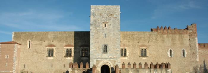
Since it was founded in 1679, Mont-Louis has experienced an extraordinary military past. In addition to the political decisions made by King Louis XIV, the enlightened plans drawn up by the well-known French architect Vauban and the very active and rigorous surveillance of the Secretary of State for War Louvois, the place has been the home and domain of soldiers!

Following the signing of the Treaty of the Pyrenees in 1659 and on the behest of King Louis XIV who wished to secure this region only recently reclaimed by Spain, Vauban, General Commissioner of Fortifications, designed this stronghold from the ground up in 1679. The special strategic location, at the crossroads of the comarques of Conflent, Capcir and Cerdanya, determined the final choice of the site. Moreover, this position gave easy access to materials, pastures, mills, wood and fields.

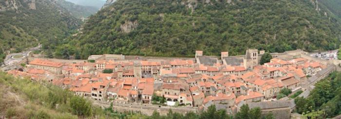
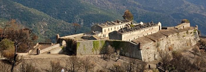
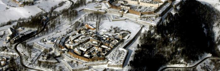
Mont-Louis was planned over two terraces: the citadel and the town.

The original plans included a lower town for the sutlers, stables and feedstores as well as a redoubt but they were never built for lack of funds.

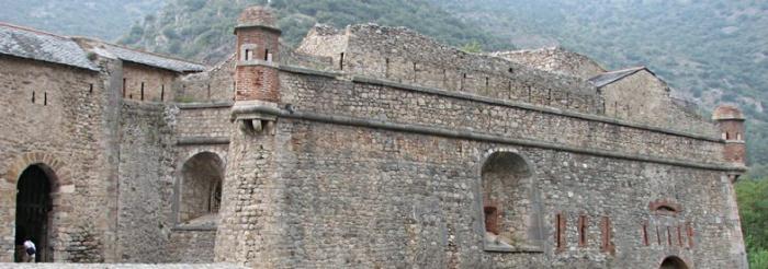
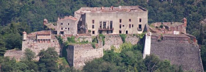
As concerns the military citadel, the view from which stretched from the Canigou to the Serra del Cadi, the defences were based on typical Vauban features: bastions, battered curtain walls and demi-lunes. While the chapel, the arsenal and two powder stores were completed, the governor's house, chaplain’s quarters and the hall to provide shelter for the soldiers never got off the ground.

Adhering to simple principles, Vauban then set about organising the interior layout of the new town to house a small middle class of craftsmen with infantry barracks either side of the sole entryway into the citadel. It met military requirements and was also a practical place to live and work with a simple and well-ordered layout where the command, combat and civilian activities were harmoniously integrated.


During this period of temporary peace, the soldiers provided most of the labour, in particular the Vierzet-Famechon, Stoppa Brendelé, Furstemberg and Castries regiments. There were many soldiers living around Mont-Louis - 3,700 were present when Louvois visited the site in 1680, all paid a poor daily wage for such harsh labour in tough conditions, not least the severe climate in Mont-Louis. They were supervised by specialised craftsmen (masons, stonecutters, carpenters, joiners, blacksmiths, well-diggers and the like) and overseen by quartermasters and engineers working for the King. Any prestige from wearing the uniform was sacrificed to the meanliness of their task.


In 1681, some 29 months after Vauban’s visit, most of the work was completed and the fortress was considered to be in a state of defence. On 26 October, the first governor, François de Fortia, Marquess of Durban, took possession of the place during a sumptuous celebration amid “loud cries of 'Long live the King!’ by the people of Cerdagne who came in droves and were delighted to witness such a ceremony”. Henceforth, Mont-Louis marked the final military southern border and was well positioned to keep close watch over the stronghold of Puigcerdà in Spanish Cerdagne. The excellent choice of location has persisted through the centuries to today.


In 1793, the fortress was central to the military events taking place in Cerdagne. Mont-Louis was renamed Mont-Libre. Taking advantage of the chaotic situation in France, the King of Spain used the French regicide as an excuse to send in his troops to invade the entire region of the Pyrénées-Orientales. In Cerdagne, General Dagobert pushed back the Spanish army twice. In July 1793, the Spanish troops occupying the Col de la Perche passage were routed out and in September those camped above Canaveilles were resoundingly defeated. General Dagobert continued his efforts and invaded Spanish Cerdagne and Puigcerdà, where he died in 1794 (Monuent Dagobert stands on Place de l’Eglise).

Peace returned on 1 August 1795 and Mont-Libre was essentially used as a storehouse by the army stationed in Cerdagne. Monte-Libre reverted back to its name of Mont-Louis on 24 October 1803. In 1808, Mont-Louis became a huge transit camp and a hospital for the Spanish army. With the Restoration, Mont-Louis’s defensive importance was more related to its topography than to the fortress itself. The work resumed with intensity in 1887 to improve the Mont-Louis’ defences in particular its immediate surroundings.


The World Wars saw floods of emigrants crammed within the fortress, during the Spanish Civil War in 1936 before the German Occupation and the liberation of the site by the Free French Forces. In 1946 the fortress reclaimed its original function as a military stronghold when the 11th BPC parachute regiment were stationed there and then in 1964 the site became the National Commando Training Centre.

This centre dedicated to French expertise in commando training instructed military personnel (officers, NCOs and other ranks) from the land and air forces, the national gendarmerie and foreign armies, but was also a training centre with special programmes for war correspondents, STAPS students (physical education) and personnel from the justice and interior ministries.


But the fortress did retain one unique architectural feature: the Puits des Forçats (Convicts’ Well), with its enormous wheel that supplied water to the site (open all year round to visitors). The town walls also harbour the first solar furnace with double reflection built in 1949 (also open to visitors through the year). Its church, dedicated to St Louis, was started in 1733 based on the model of the chapel in the citadel. Inside there is a series of Roussillon baroque altarpieces dating from the 17th and 18th centuries with a very fine statue of Christ made of polychrome wood (17th century) in the Rhenish style.


Mont-Louis Tourist Information Office

3 rue Lieutenant Pruneta 66210 Mont-Louis, France

Tel/fax: +33 (0)4 68 04 21 97

E-mail: otmontlouis@wanadoo.fr


Guided tours: Fortress/Puits des Forçats well: during winter, every day except Sunday from 11 am to 2 pm. Village: in winter every day except Sunday at 3.30 pm. Solar furnace: Low season: every day at 10 am, 11 am, 2 pm, 3 pm and 4 pm. Summer: every day from 10 am to 6 pm, tours every 30 minutes.

> Return to results

Practical information

Address

66210
Mont-Louis
Tél. ou fax : 04.68.04.21.97

Prices

Visits to the Citadel/Village Full price: €5 Reduced price: €4 Children (7 to 10 years): €2 Young people (11 to 18 years): €2.50 Free for children under 7

Weekly opening hours

du 1/09 au 30/06 : rom 1/09 to 30/06: open from 9.00 am to 12.30pm/2.00 pm to 5.00 pm July/August: open from 9.00 am to 12.h30pm/2.00 pm to 6.00 pm every day

Fermetures annuelles

During the Christmas holidays. 1 January, 1 May, 11 November, 25 December. Sundays and week-ends in November, December and January.

RIVESALTES CAMP MEMORIAL

© Maxppp - Belloumi

A witness to the dark years of the 20th century (the Spanish Civil War, Second World War and Algerian War), the Rivesaltes camp occupies a unique and prominent place in the history of France.

Dates for your diary > See the Memorial's full programme of arts, science and cultural events
Visit the website

View the educational offering >>>  Rivesaltes


Originally conceived as a military camp, Rivesaltes was, successively, southern France’s principal internment camp for Spanish Republicans, foreign Jews and gypsies, in 1941-42; a “guarded residence centre” for collaborators and depot for Axis POWs between 1944 and 1948; and a holding camp for harkis and their families between 1962 and 1964.

To tell its story, a memorial was built on the site of Block F of the camp, amid the ruins of the huts that were home to more than 60 000 people. Designed by architect Rudy Ricciotti, the building, with an area of 4 000 m2, is both a reference centre for the history of the forced displacement and detention of people, and a key remembrance site.


Sources : ©MEMORIAL DU CAMP DE RIVESALTES
© Maxppp - Belloumi


> Return to results

Practical information

Address

avenue christian bourquin 66600
Rivesaltes
0468083970

Prices

- Plein tarif 8€- Jeunes gratuit jusqu’à 18 ans - Groupes de 10 à 25 personnes 150€ (visite guidée) De 25 à 50 personnes 250 € (visite guidée)- Gratuité : scolairesPass/tarifs groupés éventuels A partir de 10 personnes 5€ (visite libre)

Weekly opening hours

10h à 18h Du mardi au dimanche du 01/11 au 31/03Tous les jours du 01/04 au 31/10

Fermetures annuelles

1° janvier, 1° mai, 1 novembre, 25 décembreOffice de tourisme de référence - 8 avenue Ledru Rollin - 66600 RIVESALTES - Tel +33 4 68 64 04 04

The fortified town of Perpignan

Palace of the Kings of Majorca Source: ©Renalias Josep - License Creative Commons - Public domain

It was the scene of invasions, battles during the war of the Spanish succession, Napoleonic wars and fights against Nazism.

Perpignan is a border town in the Pyrénées-Orientales département of France and a place of passage.


Situated on Via Domitia – ancestor of today's No. 9 motorway –, it was the scene of invasions, rivalry between France and Catalonia, battles during the war of Spanish succession and then the Napoleonic wars, and fights against Nazism.


Owned by the Kingdom of Majorca, James II, known as "the Conqueror", settled in Perpignan in 1276 and raised the town to the status of a capital. He had his palace built there, which is the oldest royal residence in France. His son, James III, was driven out by Peter IV of Aragon. The Palace of the Kings of Majorca then became a temporary residence for the kings of Aragon. Pope Benedict XIII stayed there in 1408.


The building is a fortified palace in the Gothic style, organised around three courtyards. The entrance is protected by a moat and a crenelated barbican. Its architects were Ramon Pau and Pons Descoll. As a result of the 16th-century wars between France and Spain, Perpignan changed from being a border town to being a citadel, the border stronghold: in 1540, Charles Quint added a remote line of fortification to the citadel; Philip II of Spain had the red brick ramparts built in 1587 in a hexagonal shape.

After becoming part of the Kingdom of France by the Treaty of the Pyrenees in 1659, Perpignan became a proper garrison town.

Vauban reinforced the defence system by adding fortified structures inside and outside the wall built by Philip II: six half-moons were added. He suggested building living quarters inside the citadel and, to solve the issue of expulsions caused by extending the place of arms, he suggested building a "new town" to the north, which he included in his plan of the exterior wall. The military architect incorporated it into a clever defence mechanism on the Catalonia border. He closed the lines of communication via the Collioure - Port-Vendres - Fort de Bellegarde fortifications.
 

To prevent an invasion via secondary cols (in the Tech and Cerdagne valleys), he designed Prats-de-Mollo, Fort des Bains, Mont-Louis and Villefranche-de-Conflent. The rear of the system was reinforced by Perpignan.
The Revolution and the Empire developed the military character of the city and even claimed a number of public monuments and religious rights-of-way for the troop.


Perpignan Tourist Office

Palais des Congrès - Place Armand Lanoux BP 215 66002 Perpignan Cedex

Tel: +33 (0)4.68.66.30.30

Fax: +33 (0)4.68.66.30.26

E-mail: contact-office@perpignan.fr


Palace of the Kings of Majorca

4 rue des Archers 66000 Perpignan

Tel.: +33 (0)4 68 34 48 29


Summer opening times: closes at 6pm. Winter opening times: 9am to 5pm


Closed on 01/01, 05/01, 01/11 and 25/12


Quiz: Forts and citadels

> Return to results

Practical information

Address

Place Jean Moulin 66000
Perpignan
Tel : 04.68.66.30.30Télécopie : 04.68.66.30.26 Palais des Rois de Majorque4 rue des Archers66000 PerpignanTél : 04 68 34 48 29

Weekly opening hours

Ouvert 7/7 toute l'année. Du 1er septembre au 31 mai : de 9h à 17h Du 1er juin au 30 septembre : de 10h à 18h

Fermetures annuelles

Fermé les 1er janvier, 1er mai, 1er novembre et 25 décembre.